Tegucigalpa elevation
Tegucigalpa (Francisco Morazán), Honduras elevation is 944 meters and Tegucigalpa elevation in feet is 3097 ft above sea level [src 1]. Tegucigalpa is a capital of a political entity (feature code) with elevation that is 401 meters (1316 ft) bigger than average city elevation in Honduras.
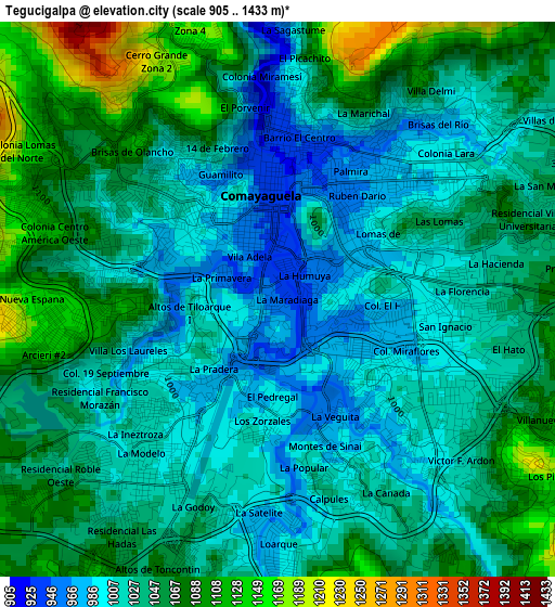
Below is the Elevation map of Tegucigalpa, which displays elevation range with different colors. Scale of the first map is from 905 to 1433 m (2969 to 4701 ft) with average elevation of 1040.4 meters (=3413 ft) [note 1]
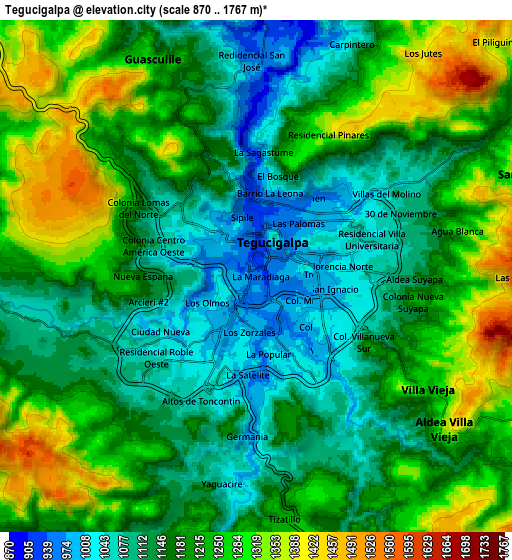
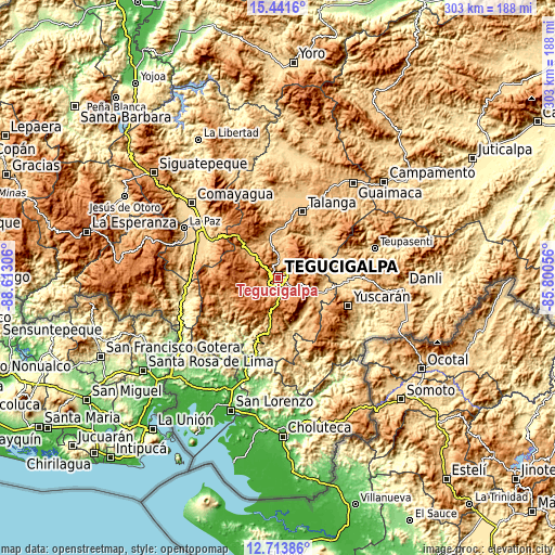
These maps also provides idea of topography and contour of this city, they are displayed at different zoom levels. More info about maps, scale and edge coordinates you can find below images.
| \ | Map #1 | Map #2 | Topo.Map |
| Scale [m] | 905..1433 m | 870..1767 m | × |
| Scale [ft] | 2969..4701 ft | 2854..5797 ft | × |
| Average | 1040.4 m = 3413 ft | 1193.7 m = 3916 ft | × |
| Width | 9.48 km = 5.9 mi | 18.96 km = 11.8 mi | 303.3 km = 188.5 mi |
| Height | 9.48 km = 5.9 mi | 18.96 km = 11.8 mi | 303.3 km = 188.5 mi |
| ↑Max Latitude | 14.124421° | 14.167034° | 15.4416° |
| Latitude at center | 14.0818° | 14.0818° | 14.0818° |
| ↓Min Latitude | 14.039171° | 13.996535° | 12.71386° |
| ← Min Longitude | -87.250755° | -87.294701° | -88.61306° |
| Longitude center | -87.20681° | -87.20681° | -87.20681° |
| →Max Longitude | -87.162865° | -87.118919° | -85.80056° |
Nearby cities:
Cities around Tegucigalpa sort by population:
• Támara elevation 1304 m
15.6 km,  299°
299°
• Villa Nueva 1358 m
9.6 km,  124°
124°
• Santa Lucía 1550 m
9.9 km,  78°
78°
• Río Abajo 1027 m
9.5 km,  353°
353°
• Yaguacire 1030 m
7.3 km,  188°
188°
• El Lolo 1551 m
7.5 km, 300°
• Cofradía 1131 m
15.2 km,  9°
9°
• El Chimbo 1213 m
11.3 km,  59°
59°
• El Tablón 1040 m
6.9 km,  141°
141°
• El Terrero 1168 m
15.2 km,  96°
96°
• Santa Ana 1455 m
18.1 km,  202°
202°
• Mateo 1127 m
11.8 km,  270°
270°
Multilingual:
 En español:
Tegucigalpa elevación 944 m.
 En France:
Tegucigalpa élévation 944 m.
 Auf Deutsch:
Tegucigalpa höhe über dem Meeresspiegel ist 944 m.

Sources and notes:
- [note 1] Map square and city borders are not equal. Map elevation data is calculated only from area inside that square.
- [src 1] Elevation data from geonames database provided with same terms of usage.
- [src 2] The elevation map of Tegucigalpa is generated using elevation data from NASA's 3 arcsec (90m) resolution SRTM data.
- [src 3] Base (background) map © OpenStreetMap contributors tiles are generated by Geofabrik and OpenTopoMap.
Copyright & License:
This Tegucigalpa Elevation Map is licensed under CC BY-SA. You may reuse any part from this page, if you give a proper credit by linking to this URL:
 More info on terms of use page.