Morocelí elevation
Morocelí (El Paraíso), Honduras elevation is 625 meters and Morocelí elevation in feet is 2051 ft above sea level [src 1]. Morocelí is a populated place (feature code) with elevation that is 82 meters (269 ft) bigger than average city elevation in Honduras.
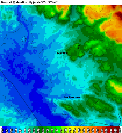
Below is the Elevation map of Morocelí, which displays elevation range with different colors. Scale of the first map is from 563 to 939 m (1847 to 3081 ft) with average elevation of 646.6 meters (=2121 ft) [note 1]
These maps also provides idea of topography and contour of this city, they are displayed at different zoom levels. More info about maps, scale and edge coordinates you can find below images.
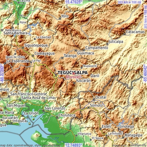
| \ | Map #1 | Topo.Map |
| Scale [m] | 563..939 m | × |
| Scale [ft] | 1847..3081 ft | × |
| Average | 646.6 m = 2121 ft | × |
| Width | 9.48 km = 5.9 mi | 303.2 km = 188.4 mi |
| Height | 9.48 km = 5.9 mi | 303.3 km = 188.5 mi |
| ↑Max Latitude | 14.159284° | 15.47625° |
| Latitude at center | 14.11667° | 14.11667° |
| ↓Min Latitude | 14.074048° | 12.74893° |
| ← Min Longitude | -86.910615° | -88.27292° |
| Longitude center | -86.86667° | -86.86667° |
| →Max Longitude | -86.822725° | -85.46042° |
Nearby cities:
Cities around Morocelí sort by population:
• Villa de San Francisco elevation 777 m
12.1 km,  297°
297°
• Valle de Ángeles 1278 m
18.3 km,  281°
281°
• Teupasenti 773 m
21.1 km,  58°
58°
• San Juan de Flores 742 m
24.5 km,  312°
312°
• Güinope 1310 m
26.9 km,  195°
195°
• Jacaleapa 826 m
24.3 km,  117°
117°
• Yuscarán 958 m
19.3 km,  175°
175°
• Villa Nueva 1358 m
30.2 km,  252°
252°
• Santa Lucía 1550 m
27 km,  266°
266°
• San Matías 801 m
29.2 km, 120°
• El Chimbo 1213 m
27 km, 273°
• El Terrero 1168 m
22.3 km,  255°
255°
Multilingual:
 En español:
Morocelí elevación 625 m.
 En France:
Morocelí élévation 625 m.
 Auf Deutsch:
Morocelí höhe über dem Meeresspiegel ist 625 m.

Sources and notes:
- [note 1] Map square and city borders are not equal. Map elevation data is calculated only from area inside that square.
- [src 1] Elevation data from geonames database provided with same terms of usage.
- [src 2] The elevation map of Morocelí is generated using elevation data from NASA's 3 arcsec (90m) resolution SRTM data.
- [src 3] Base (background) map © OpenStreetMap contributors tiles are generated by Geofabrik and OpenTopoMap.
Copyright & License:
This Morocelí Elevation Map is licensed under CC BY-SA. You may reuse any part from this page, if you give a proper credit by linking to this URL:
 More info on terms of use page.