Teupasenti elevation
Teupasenti (El Paraíso), Honduras elevation is 773 meters and Teupasenti elevation in feet is 2536 ft above sea level [src 1]. Teupasenti is a populated place (feature code) with elevation that is 230 meters (755 ft) bigger than average city elevation in Honduras.
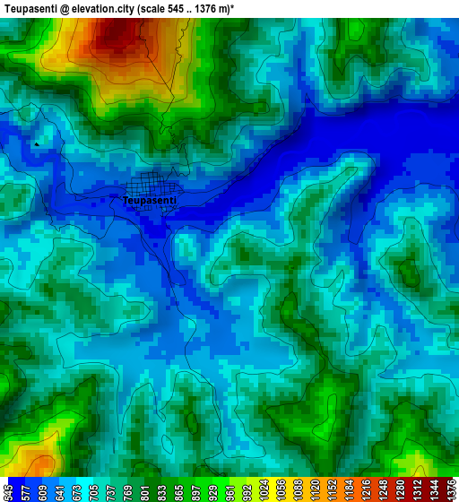
Below is the Elevation map of Teupasenti, which displays elevation range with different colors. Scale of the first map is from 545 to 1376 m (1788 to 4514 ft) with average elevation of 735.8 meters (=2414 ft) [note 1]
These maps also provides idea of topography and contour of this city, they are displayed at different zoom levels. More info about maps, scale and edge coordinates you can find below images.
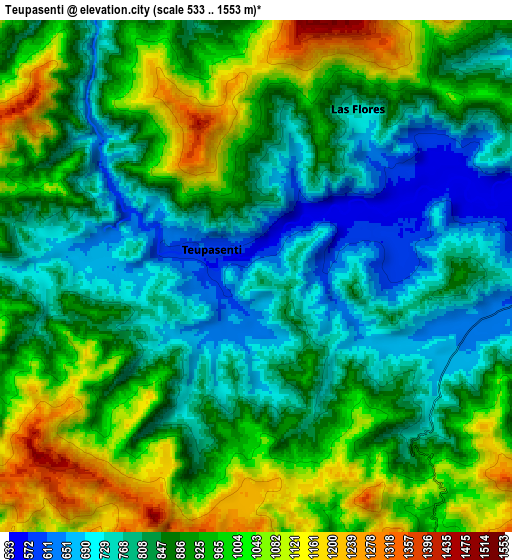
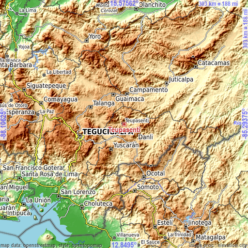
| \ | Map #1 | Map #2 | Topo.Map |
| Scale [m] | 545..1376 m | 533..1553 m | × |
| Scale [ft] | 1788..4514 ft | 1749..5095 ft | × |
| Average | 735.8 m = 2414 ft | 890.8 m = 2923 ft | × |
| Width | 9.47 km = 5.9 mi | 18.95 km = 11.8 mi | 303.1 km = 188.3 mi |
| Height | 9.47 km = 5.9 mi | 18.95 km = 11.8 mi | 303.1 km = 188.3 mi |
| ↑Max Latitude | 14.259265° | 14.301853° | 15.57562° |
| Latitude at center | 14.21667° | 14.21667° | 14.21667° |
| ↓Min Latitude | 14.174067° | 14.131455° | 12.8495° |
| ← Min Longitude | -86.743945° | -86.787891° | -88.10625° |
| Longitude center | -86.7° | -86.7° | -86.7° |
| →Max Longitude | -86.656055° | -86.612109° | -85.29375° |
Nearby cities:
Cities around Teupasenti sort by population:
• Danlí elevation 763 m
24 km,  148°
148°
• Villa de San Francisco 777 m
29.3 km,  259°
259°
• Valle de Ángeles 1278 m
36.7 km, 258°
• San Juan de Flores 742 m
36.4 km,  278°
278°
• Morocelí 625 m
21.1 km,  238°
238°
• Jacaleapa 826 m
22.5 km,  170°
170°
• Yuscarán 958 m
34.5 km,  208°
208°
• San Diego 585 m
31.2 km,  126°
126°
• San Matías 801 m
26.9 km,  164°
164°
• Araulí 749 m
33.8 km, 151°
• Las Ánimas 545 m
14.8 km,  75°
75°
• El Benque 563 m
32.4 km, 129°
Multilingual:
 En español:
Teupasenti elevación 773 m.
 En France:
Teupasenti élévation 773 m.
 Auf Deutsch:
Teupasenti höhe über dem Meeresspiegel ist 773 m.

Sources and notes:
- [note 1] Map square and city borders are not equal. Map elevation data is calculated only from area inside that square.
- [src 1] Elevation data from geonames database provided with same terms of usage.
- [src 2] The elevation map of Teupasenti is generated using elevation data from NASA's 3 arcsec (90m) resolution SRTM data.
- [src 3] Base (background) map © OpenStreetMap contributors tiles are generated by Geofabrik and OpenTopoMap.
Copyright & License:
This Teupasenti Elevation Map is licensed under CC BY-SA. You may reuse any part from this page, if you give a proper credit by linking to this URL:
 More info on terms of use page.