Danlí elevation
Danlí (El Paraíso), Honduras elevation is 763 meters and Danlí elevation in feet is 2503 ft above sea level [src 1]. Danlí is a populated place (feature code) with elevation that is 220 meters (722 ft) bigger than average city elevation in Honduras.
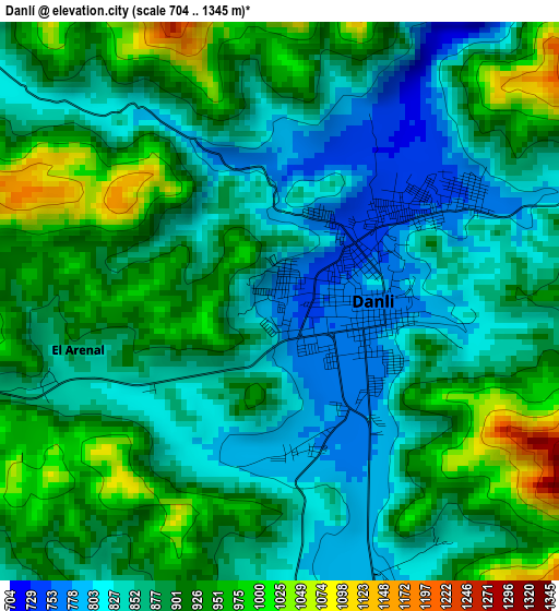
Below is the Elevation map of Danlí, which displays elevation range with different colors. Scale of the first map is from 704 to 1345 m (2310 to 4413 ft) with average elevation of 887 meters (=2910 ft) [note 1]
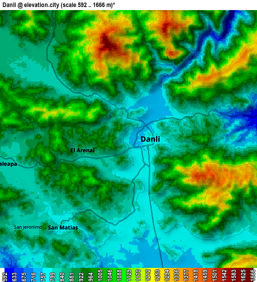
These maps also provides idea of topography and contour of this city, they are displayed at different zoom levels. More info about maps, scale and edge coordinates you can find below images.
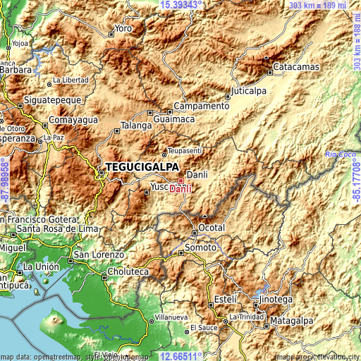
| \ | Map #1 | Map #2 | Topo.Map |
| Scale [m] | 704..1345 m | 592..1666 m | × |
| Scale [ft] | 2310..4413 ft | 1942..5466 ft | × |
| Average | 887 m = 2910 ft | 933 m = 3061 ft | × |
| Width | 9.48 km = 5.9 mi | 18.96 km = 11.8 mi | 303.4 km = 188.5 mi |
| Height | 9.48 km = 5.9 mi | 18.96 km = 11.8 mi | 303.4 km = 188.5 mi |
| ↑Max Latitude | 14.07596° | 14.118582° | 15.39343° |
| Latitude at center | 14.03333° | 14.03333° | 14.03333° |
| ↓Min Latitude | 13.990692° | 13.948047° | 12.66511° |
| ← Min Longitude | -86.627275° | -86.671221° | -87.98958° |
| Longitude center | -86.58333° | -86.58333° | -86.58333° |
| →Max Longitude | -86.539385° | -86.495439° | -85.17708° |
Nearby cities:
Cities around Danlí sort by population:
• El Paraíso elevation 804 m
18.9 km,  169°
169°
• Teupasenti 773 m
24 km,  328°
328°
• Jacaleapa 826 m
9.2 km,  258°
258°
• El Obraje 527 m
16.6 km,  102°
102°
• Cuyalí 772 m
17.1 km, 167°
• Santa Cruz 864 m
19.3 km,  196°
196°
• San Diego 585 m
12.7 km,  81°
81°
• San Matías 801 m
7.7 km,  224°
224°
• Araulí 749 m
9.9 km,  158°
158°
• Jutiapa 484 m
20.5 km,  105°
105°
• Las Ánimas 545 m
24.2 km,  4°
4°
• El Benque 563 m
12.6 km,  90°
90°
Multilingual:
 En español:
Danlí elevación 763 m.
 En France:
Danlí élévation 763 m.


Sources and notes:
- [note 1] Map square and city borders are not equal. Map elevation data is calculated only from area inside that square.
- [src 1] Elevation data from geonames database provided with same terms of usage.
- [src 2] The elevation map of Danlí is generated using elevation data from NASA's 3 arcsec (90m) resolution SRTM data.
- [src 3] Base (background) map © OpenStreetMap contributors tiles are generated by Geofabrik and OpenTopoMap.
Copyright & License:
This Danlí Elevation Map is licensed under CC BY-SA. You may reuse any part from this page, if you give a proper credit by linking to this URL:
 More info on terms of use page.