San Marcos de Colón elevation
San Marcos de Colón (Choluteca), Honduras elevation is 997 meters and San Marcos de Colón elevation in feet is 3271 ft above sea level [src 1]. San Marcos de Colón is a populated place (feature code) with elevation that is 454 meters (1490 ft) bigger than average city elevation in Honduras.
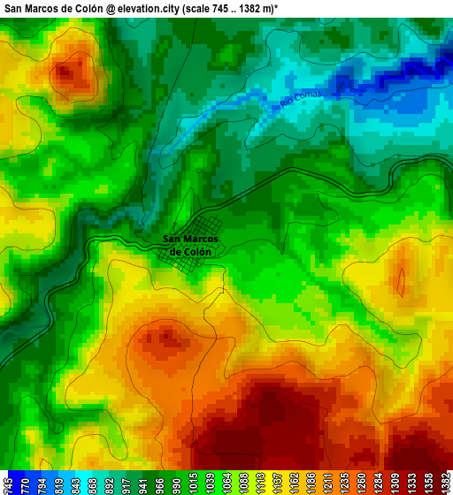
Below is the Elevation map of San Marcos de Colón, which displays elevation range with different colors. Scale of the first map is from 745 to 1382 m (2444 to 4534 ft) with average elevation of 1058.9 meters (=3474 ft) [note 1]
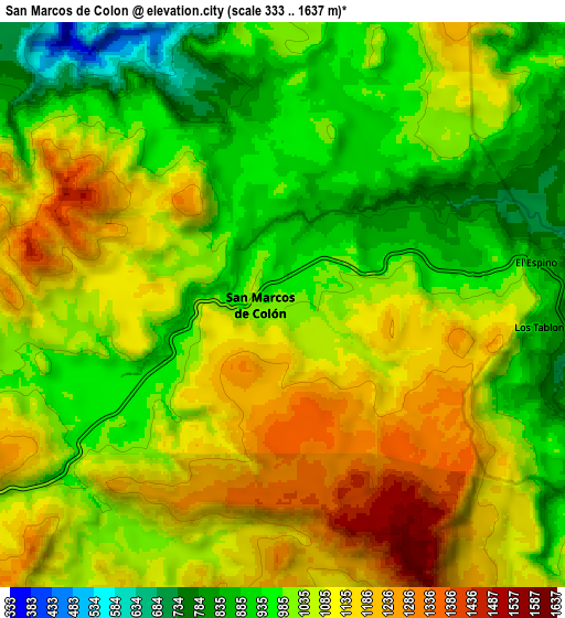
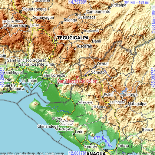
These maps also provides idea of topography and contour of this city, they are displayed at different zoom levels. More info about maps, scale and edge coordinates you can find below images.
| \ | Map #1 | Map #2 | Topo.Map |
| Scale [m] | 745..1382 m | 333..1637 m | × |
| Scale [ft] | 2444..4534 ft | 1093..5371 ft | × |
| Average | 1058.9 m = 3474 ft | 1048.2 m = 3439 ft | × |
| Width | 9.51 km = 5.9 mi | 19.01 km = 11.8 mi | 304.1 km = 189 mi |
| Height | 9.51 km = 5.9 mi | 19.01 km = 11.8 mi | 304.2 km = 189 mi |
| ↑Max Latitude | 13.476069° | 13.518801° | 14.79709° |
| Latitude at center | 13.43333° | 13.43333° | 13.43333° |
| ↓Min Latitude | 13.390583° | 13.347829° | 12.06178° |
| ← Min Longitude | -86.843945° | -86.887891° | -88.20625° |
| Longitude center | -86.8° | -86.8° | -86.8° |
| →Max Longitude | -86.756055° | -86.712109° | -85.39375° |
Nearby cities:
Cities around San Marcos de Colón sort by population:
• Ciudad Choluteca elevation 53 m
44.8 km,  250°
250°
• El Triunfo 89 m
41.3 km,  211°
211°
• Santa Ana de Yusguare 69 m
37 km, 246°
• Namasigüe 54 m
44.6 km,  235°
235°
• Orocuina 121 m
33.4 km,  279°
279°
• Oropolí 472 m
42.7 km,  357°
357°
• El Puente 243 m
38.1 km, 244°
• San Lucas 1290 m
37.1 km,  334°
334°
• Corpus 378 m
30 km, 237°
• Duyure 753 m
22.3 km, 355°
• Liure 223 m
33.6 km,  289°
289°
• Texíguat 350 m
34 km,  315°
315°
Multilingual:
 En español:
San Marcos de Colón elevación 997 m.
 En France:
San Marcos de Colón élévation 997 m.
 Auf Deutsch:
San Marcos de Colón höhe über dem Meeresspiegel ist 997 m.
 На русском:
San Marcos de Colón высота над уровнем моря 997 м
Sources and notes:
- [note 1] Map square and city borders are not equal. Map elevation data is calculated only from area inside that square.
- [src 1] Elevation data from geonames database provided with same terms of usage.
- [src 2] The elevation map of San Marcos de Colón is generated using elevation data from NASA's 3 arcsec (90m) resolution SRTM data.
- [src 3] Base (background) map © OpenStreetMap contributors tiles are generated by Geofabrik and OpenTopoMap.
Copyright & License:
This San Marcos de Colón Elevation Map is licensed under CC BY-SA. You may reuse any part from this page, if you give a proper credit by linking to this URL:
 More info on terms of use page.