San Lucas elevation
San Lucas (El Paraíso), Honduras elevation is 1290 meters and San Lucas elevation in feet is 4232 ft above sea level [src 1]. San Lucas is a populated place (feature code) with elevation that is 747 meters (2451 ft) bigger than average city elevation in Honduras.
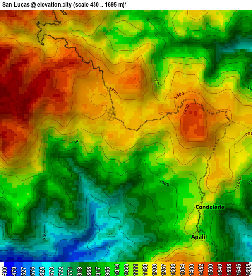
Below is the Elevation map of San Lucas, which displays elevation range with different colors. Scale of the first map is from 430 to 1695 m (1411 to 5561 ft) with average elevation of 1097.7 meters (=3601 ft) [note 1]
These maps also provides idea of topography and contour of this city, they are displayed at different zoom levels. More info about maps, scale and edge coordinates you can find below images.
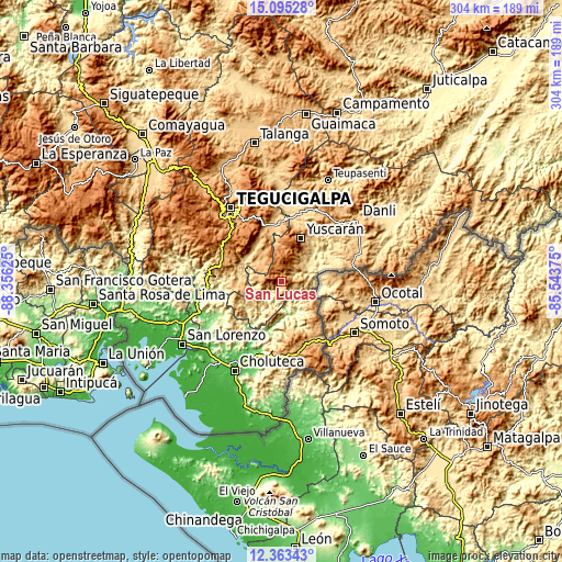
| \ | Map #1 | Topo.Map |
| Scale [m] | 430..1695 m | × |
| Scale [ft] | 1411..5561 ft | × |
| Average | 1097.7 m = 3601 ft | × |
| Width | 9.49 km = 5.9 mi | 303.8 km = 188.8 mi |
| Height | 9.49 km = 5.9 mi | 303.8 km = 188.8 mi |
| ↑Max Latitude | 13.776015° | 15.09528° |
| Latitude at center | 13.73333° | 13.73333° |
| ↓Min Latitude | 13.690637° | 12.36343° |
| ← Min Longitude | -86.993945° | -88.35625° |
| Longitude center | -86.95° | -86.95° |
| →Max Longitude | -86.906055° | -85.54375° |
Nearby cities:
Cities around San Lucas sort by population:
• San Marcos de Colón elevation 997 m
37.1 km,  154°
154°
• Güinope 1310 m
16.8 km,  6°
6°
• Yuscarán 958 m
25.7 km,  24°
24°
• Villa Nueva 1358 m
38.8 km,  329°
329°
• Sabanagrande 965 m
34.4 km,  283°
283°
• Orocuina 121 m
32.6 km,  210°
210°
• Santa Cruz 864 m
37.3 km,  66°
66°
• Oropolí 472 m
17.1 km,  57°
57°
• Duyure 753 m
18.2 km,  127°
127°
• Cerro Grande 1090 m
33.7 km,  285°
285°
• Liure 223 m
26.8 km, 214°
• Texíguat 350 m
12.2 km,  220°
220°
Multilingual:
 En español:
San Lucas elevación 1290 m.
 En France:
San Lucas élévation 1290 m.
 Auf Deutsch:
San Lucas höhe über dem Meeresspiegel ist 1290 m.

Sources and notes:
- [note 1] Map square and city borders are not equal. Map elevation data is calculated only from area inside that square.
- [src 1] Elevation data from geonames database provided with same terms of usage.
- [src 2] The elevation map of San Lucas is generated using elevation data from NASA's 3 arcsec (90m) resolution SRTM data.
- [src 3] Base (background) map © OpenStreetMap contributors tiles are generated by Geofabrik and OpenTopoMap.
Copyright & License:
This San Lucas Elevation Map is licensed under CC BY-SA. You may reuse any part from this page, if you give a proper credit by linking to this URL:
 More info on terms of use page.