Liure elevation
Liure (El Paraíso), Honduras elevation is 223 meters and Liure elevation in feet is 732 ft above sea level [src 1]. Liure is a populated place (feature code) with elevation that is 320 meters (1050 ft) smaller than average city elevation in Honduras.
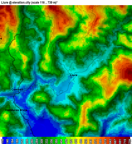
Below is the Elevation map of Liure, which displays elevation range with different colors. Scale of the first map is from 116 to 739 m (381 to 2425 ft) with average elevation of 351 meters (=1152 ft) [note 1]
These maps also provides idea of topography and contour of this city, they are displayed at different zoom levels. More info about maps, scale and edge coordinates you can find below images.
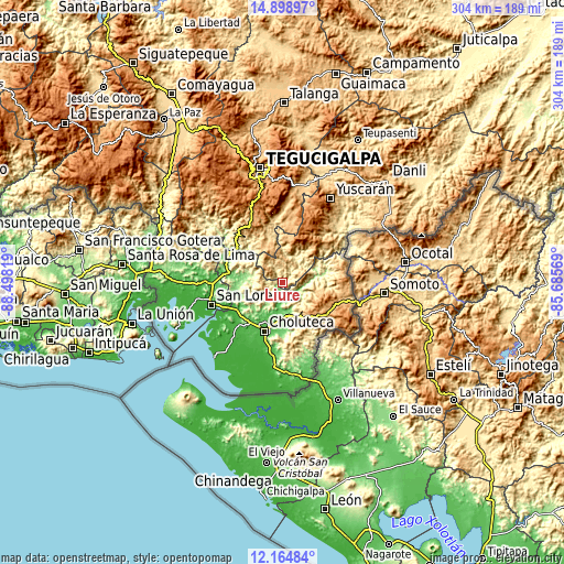
| \ | Map #1 | Topo.Map |
| Scale [m] | 116..739 m | × |
| Scale [ft] | 381..2425 ft | × |
| Average | 351 m = 1152 ft | × |
| Width | 9.5 km = 5.9 mi | 304 km = 188.9 mi |
| Height | 9.5 km = 5.9 mi | 304 km = 188.9 mi |
| ↑Max Latitude | 13.578551° | 14.89897° |
| Latitude at center | 13.53583° | 13.53583° |
| ↓Min Latitude | 13.493101° | 12.16484° |
| ← Min Longitude | -87.135885° | -88.49819° |
| Longitude center | -87.09194° | -87.09194° |
| →Max Longitude | -87.047995° | -85.68569° |
Nearby cities:
Cities around Liure sort by population:
• Ciudad Choluteca elevation 53 m
28.3 km,  202°
202°
• San Marcos de Colón 997 m
33.6 km,  109°
109°
• Pespire 123 m
29.8 km,  282°
282°
• Sabanagrande 965 m
35.2 km,  329°
329°
• Santa Ana de Yusguare 69 m
26.3 km,  185°
185°
• Orocuina 121 m
6.2 km, 193°
• El Puente 243 m
28.2 km, 185°
• San Lucas 1290 m
26.8 km,  34°
34°
• Corpus 378 m
28.1 km,  167°
167°
• Duyure 753 m
31.7 km,  69°
69°
• Cerro Grande 1090 m
35.6 km, 331°
• Texíguat 350 m
14.7 km, 30°
Multilingual:
 En español:
Liure elevación 223 m.
 En France:
Liure élévation 223 m.


Sources and notes:
- [note 1] Map square and city borders are not equal. Map elevation data is calculated only from area inside that square.
- [src 1] Elevation data from geonames database provided with same terms of usage.
- [src 2] The elevation map of Liure is generated using elevation data from NASA's 3 arcsec (90m) resolution SRTM data.
- [src 3] Base (background) map © OpenStreetMap contributors tiles are generated by Geofabrik and OpenTopoMap.
Copyright & License:
This Liure Elevation Map is licensed under CC BY-SA. You may reuse any part from this page, if you give a proper credit by linking to this URL:
 More info on terms of use page.