Guanagazapa elevation
Guanagazapa (Escuintla), Guatemala elevation is 345 meters and Guanagazapa elevation in feet is 1132 ft above sea level [src 1]. Guanagazapa is a seat of a second-order administrative division (feature code) with elevation that is 922 meters (3025 ft) smaller than average city elevation in Guatemala.
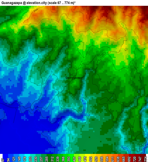
Below is the Elevation map of Guanagazapa, which displays elevation range with different colors. Scale of the first map is from 67 to 774 m (220 to 2539 ft) with average elevation of 301 meters (=988 ft) [note 1]
These maps also provides idea of topography and contour of this city, they are displayed at different zoom levels. More info about maps, scale and edge coordinates you can find below images.
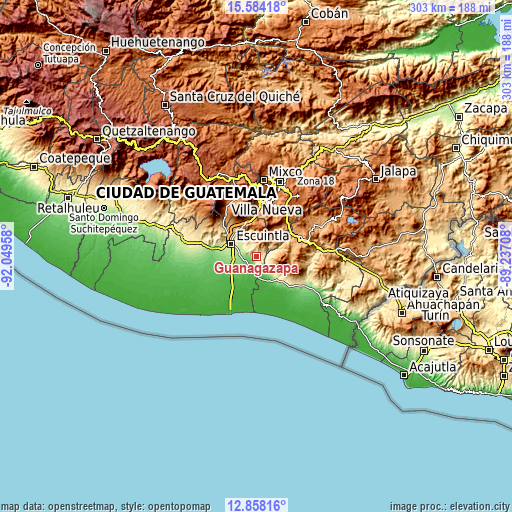
| \ | Map #1 | Topo.Map |
| Scale [m] | 67..774 m | × |
| Scale [ft] | 220..2539 ft | × |
| Average | 301 m = 988 ft | × |
| Width | 9.47 km = 5.9 mi | 303.1 km = 188.3 mi |
| Height | 9.47 km = 5.9 mi | 303.1 km = 188.3 mi |
| ↑Max Latitude | 14.267874° | 15.58418° |
| Latitude at center | 14.22528° | 14.22528° |
| ↓Min Latitude | 14.182678° | 12.85816° |
| ← Min Longitude | -90.687275° | -92.04958° |
| Longitude center | -90.64333° | -90.64333° |
| →Max Longitude | -90.599385° | -89.23708° |
Nearby cities:
Cities around Guanagazapa sort by population:
• Villa Canales elevation 1259 m
31 km,  22°
22°
• Escuintla 356 m
17.7 km,  300°
300°
• Amatitlán 1219 m
28 km,  1°
1°
• Palín 1138 m
20.6 km,  343°
343°
• Barberena 1186 m
31.7 km,  73°
73°
• Santa María de Jesús 2060 m
30.8 km,  346°
346°
• Chiquimulilla 285 m
31.9 km,  119°
119°
• Masagua 118 m
22.2 km,  263°
263°
• San Vicente Pacaya 1582 m
21.1 km, 2°
• Guazacapán 265 m
29.7 km, 124°
• Taxisco 180 m
25.8 km,  132°
132°
• Pueblo Nuevo Viñas 1231 m
18 km,  89°
89°
Multilingual:
 En español:
Guanagazapa elevación 345 m.
 En France:
Guanagazapa élévation 345 m.
 Auf Deutsch:
Guanagazapa höhe über dem Meeresspiegel ist 345 m.

Sources and notes:
- [note 1] Map square and city borders are not equal. Map elevation data is calculated only from area inside that square.
- [src 1] Elevation data from geonames database provided with same terms of usage.
- [src 2] The elevation map of Guanagazapa is generated using elevation data from NASA's 3 arcsec (90m) resolution SRTM data.
- [src 3] Base (background) map © OpenStreetMap contributors tiles are generated by Geofabrik and OpenTopoMap.
Copyright & License:
This Guanagazapa Elevation Map is licensed under CC BY-SA. You may reuse any part from this page, if you give a proper credit by linking to this URL:
 More info on terms of use page.