Escuintla elevation
Escuintla, Guatemala elevation is 356 meters and Escuintla elevation in feet is 1168 ft above sea level [src 1]. Escuintla is a seat of a first-order administrative division (feature code) with elevation that is 911 meters (2989 ft) smaller than average city elevation in Guatemala.
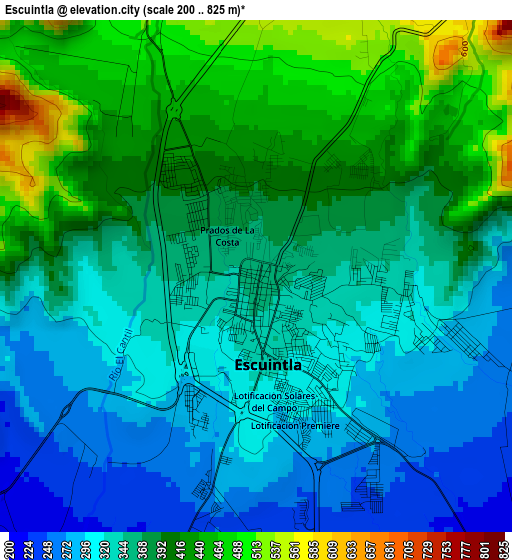
Below is the Elevation map of Escuintla, which displays elevation range with different colors. Scale of the first map is from 200 to 825 m (656 to 2707 ft) with average elevation of 365.3 meters (=1198 ft) [note 1]
These maps also provides idea of topography and contour of this city, they are displayed at different zoom levels. More info about maps, scale and edge coordinates you can find below images.
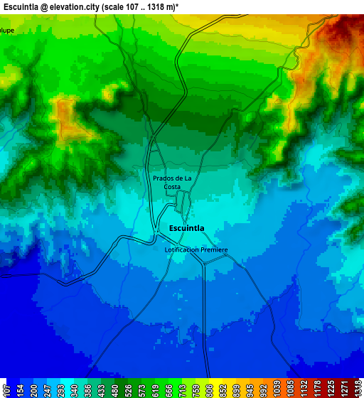
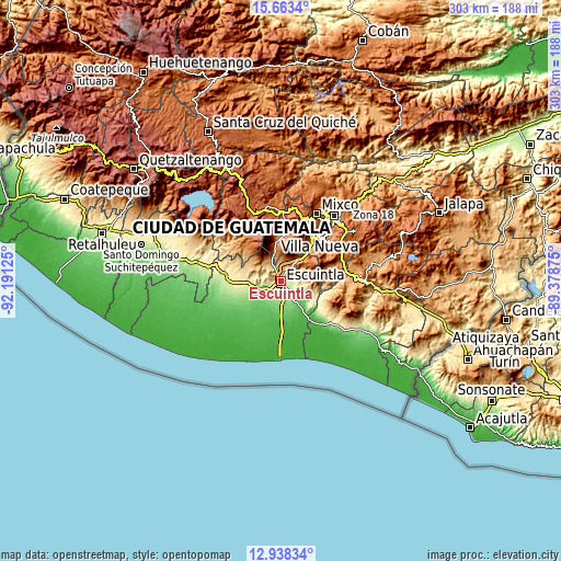
| \ | Map #1 | Map #2 | Topo.Map |
| Scale [m] | 200..825 m | 107..1318 m | × |
| Scale [ft] | 656..2707 ft | 351..4324 ft | × |
| Average | 365.3 m = 1198 ft | 414.6 m = 1360 ft | × |
| Width | 9.47 km = 5.9 mi | 18.94 km = 11.8 mi | 303 km = 188.3 mi |
| Height | 9.47 km = 5.9 mi | 18.94 km = 11.8 mi | 303 km = 188.3 mi |
| ↑Max Latitude | 14.347579° | 14.390149° | 15.6634° |
| Latitude at center | 14.305° | 14.305° | 14.305° |
| ↓Min Latitude | 14.262413° | 14.219818° | 12.93834° |
| ← Min Longitude | -90.828945° | -90.872891° | -92.19125° |
| Longitude center | -90.785° | -90.785° | -90.785° |
| →Max Longitude | -90.741055° | -90.697109° | -89.37875° |
Nearby cities:
Cities around Escuintla sort by population:
• Amatitlán elevation 1219 m
25.1 km,  40°
40°
• Santa Lucía Cotzumalguapa 392 m
25.9 km,  277°
277°
• Palín 1138 m
14.5 km, 40°
• Ciudad Vieja 1580 m
24.5 km,  5°
5°
• Alotenango 1368 m
19.6 km,  352°
352°
• Santa María de Jesús 2060 m
22.6 km,  20°
20°
• Masagua 118 m
13.2 km,  210°
210°
• San Miguel Dueñas 1459 m
24.2 km,  356°
356°
• San Vicente Pacaya 1582 m
20.1 km,  52°
52°
• La Democracia 168 m
19.3 km,  244°
244°
• Guanagazapa 345 m
17.7 km,  120°
120°
• Siquinalá 353 m
19.4 km,  270°
270°
Multilingual:
 En español:
Escuintla elevación 356 m.
 En France:
Escuintla élévation 356 m.
 Auf Deutsch:
Escuintla höhe über dem Meeresspiegel ist 356 m.

Sources and notes:
- [note 1] Map square and city borders are not equal. Map elevation data is calculated only from area inside that square.
- [src 1] Elevation data from geonames database provided with same terms of usage.
- [src 2] The elevation map of Escuintla is generated using elevation data from NASA's 3 arcsec (90m) resolution SRTM data.
- [src 3] Base (background) map © OpenStreetMap contributors tiles are generated by Geofabrik and OpenTopoMap.
Copyright & License:
This Escuintla Elevation Map is licensed under CC BY-SA. You may reuse any part from this page, if you give a proper credit by linking to this URL:
 More info on terms of use page.