Palín elevation
Palín (Escuintla), Guatemala elevation is 1138 meters and Palín elevation in feet is 3734 ft above sea level [src 1]. Palín is a seat of a second-order administrative division (feature code) with elevation that is 129 meters (423 ft) smaller than average city elevation in Guatemala.
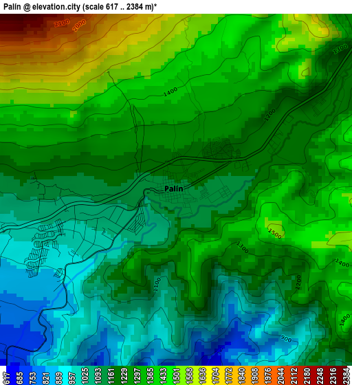
Below is the Elevation map of Palín, which displays elevation range with different colors. Scale of the first map is from 617 to 2384 m (2024 to 7822 ft) with average elevation of 1239.8 meters (=4068 ft) [note 1]
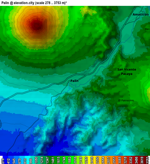
These maps also provides idea of topography and contour of this city, they are displayed at different zoom levels. More info about maps, scale and edge coordinates you can find below images.
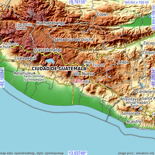
| \ | Map #1 | Map #2 | Topo.Map |
| Scale [m] | 617..2384 m | 278..3753 m | × |
| Scale [ft] | 2024..7822 ft | 912..12313 ft | × |
| Average | 1239.8 m = 4068 ft | 1313 m = 4308 ft | × |
| Width | 9.47 km = 5.9 mi | 18.93 km = 11.8 mi | 302.9 km = 188.2 mi |
| Height | 9.47 km = 5.9 mi | 18.93 km = 11.8 mi | 302.9 km = 188.2 mi |
| ↑Max Latitude | 14.44614° | 14.488692° | 15.76135° |
| Latitude at center | 14.40358° | 14.40358° | 14.40358° |
| ↓Min Latitude | 14.361012° | 14.318436° | 13.03749° |
| ← Min Longitude | -90.740535° | -90.784481° | -92.10284° |
| Longitude center | -90.69659° | -90.69659° | -90.69659° |
| →Max Longitude | -90.652645° | -90.608699° | -89.29034° |
Nearby cities:
Cities around Palín sort by population:
• Villa Nueva elevation 1363 m
18.1 km,  41°
41°
• Petapa 1269 m
18.2 km,  52°
52°
• Escuintla 356 m
14.5 km,  220°
220°
• Amatitlán 1219 m
10.6 km, 38°
• Antigua Guatemala 1539 m
18 km,  346°
346°
• Ciudad Vieja 1580 m
15.2 km,  331°
331°
• Alotenango 1368 m
14.7 km,  305°
305°
• Santa María de Jesús 2060 m
10.2 km, 351°
• San Miguel Dueñas 1459 m
17.2 km,  320°
320°
• San Antonio Aguas Calientes 1503 m
18.3 km, 330°
• San Vicente Pacaya 1582 m
6.6 km,  79°
79°
• Magdalena Milpas Altas 2029 m
16.2 km,  8°
8°
Multilingual:
 En español:
Palín elevación 1138 m.
 En France:
Palín élévation 1138 m.


Sources and notes:
- [note 1] Map square and city borders are not equal. Map elevation data is calculated only from area inside that square.
- [src 1] Elevation data from geonames database provided with same terms of usage.
- [src 2] The elevation map of Palín is generated using elevation data from NASA's 3 arcsec (90m) resolution SRTM data.
- [src 3] Base (background) map © OpenStreetMap contributors tiles are generated by Geofabrik and OpenTopoMap.
Copyright & License:
This Palín Elevation Map is licensed under CC BY-SA. You may reuse any part from this page, if you give a proper credit by linking to this URL:
 More info on terms of use page.