Iztapa elevation
Iztapa (Escuintla), Guatemala elevation is 3 meters and Iztapa elevation in feet is 10 ft above sea level [src 1]. Iztapa is a seat of a second-order administrative division (feature code) with elevation that is 1264 meters (4147 ft) smaller than average city elevation in Guatemala.
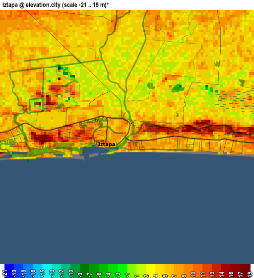
Below is the Elevation map of Iztapa, which displays elevation range with different colors. Scale of the first map is from -21 to 19 m (-69 to 62 ft) with average elevation of 5.4 meters (=18 ft) [note 1]
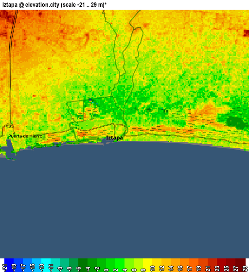
These maps also provides idea of topography and contour of this city, they are displayed at different zoom levels. More info about maps, scale and edge coordinates you can find below images.
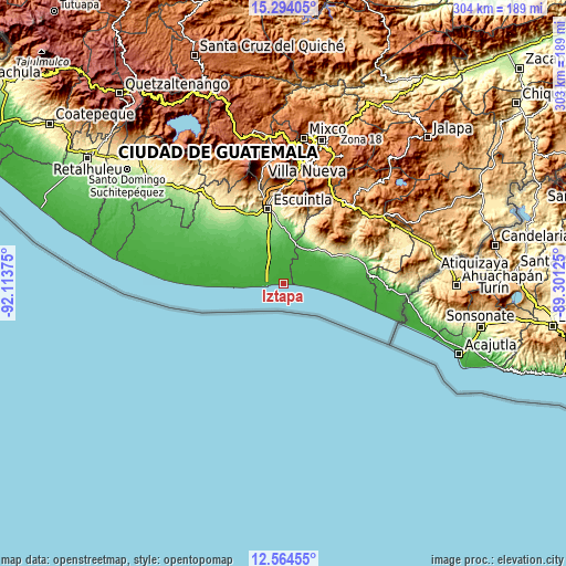
| \ | Map #1 | Map #2 | Topo.Map |
| Scale [m] | -21..19 m | -21..29 m | × |
| Scale [ft] | -69..62 ft | -69..95 ft | × |
| Average | 5.4 m = 18 ft | 8.3 m = 27 ft | × |
| Width | 9.48 km = 5.9 mi | 18.97 km = 11.8 mi | 303.5 km = 188.6 mi |
| Height | 9.48 km = 5.9 mi | 18.97 km = 11.8 mi | 303.5 km = 188.6 mi |
| ↑Max Latitude | 13.975978° | 14.018619° | 15.29405° |
| Latitude at center | 13.93333° | 13.93333° | 13.93333° |
| ↓Min Latitude | 13.890674° | 13.84801° | 12.56455° |
| ← Min Longitude | -90.751445° | -90.795391° | -92.11375° |
| Longitude center | -90.7075° | -90.7075° | -90.7075° |
| →Max Longitude | -90.663555° | -90.619609° | -89.30125° |
Nearby cities:
Cities around Iztapa sort by population:
• Escuintla elevation 356 m
42.2 km,  348°
348°
• La Gomera 38 m
40.9 km,  293°
293°
• Puerto San José 6 m
12.3 km,  266°
266°
• Chiquimulilla 285 m
38.6 km,  64°
64°
• Masagua 118 m
33.6 km,  333°
333°
• Guazacapán 265 m
35.1 km, 63°
• Taxisco 180 m
29.8 km, 60°
• La Democracia 168 m
42 km,  321°
321°
• Pueblo Nuevo Viñas 1231 m
41 km,  37°
37°
• Guanagazapa 345 m
33.2 km,  12°
12°
• San Juan Tecuaco 414 m
50.4 km,  70°
70°
• Siquinalá 353 m
49.9 km, 326°
Multilingual:
 En español:
Iztapa elevación 3 m.
 En France:
Iztapa élévation 3 m.


Sources and notes:
- [note 1] Map square and city borders are not equal. Map elevation data is calculated only from area inside that square.
- [src 1] Elevation data from geonames database provided with same terms of usage.
- [src 2] The elevation map of Iztapa is generated using elevation data from NASA's 3 arcsec (90m) resolution SRTM data.
- [src 3] Base (background) map © OpenStreetMap contributors tiles are generated by Geofabrik and OpenTopoMap.
Copyright & License:
This Iztapa Elevation Map is licensed under CC BY-SA. You may reuse any part from this page, if you give a proper credit by linking to this URL:
 More info on terms of use page.