San Luis Ixcán elevation
San Luis Ixcán (Quiché), Guatemala elevation is 294 meters and San Luis Ixcán elevation in feet is 965 ft above sea level [src 1]. San Luis Ixcán is a populated place (feature code) with elevation that is 973 meters (3192 ft) smaller than average city elevation in Guatemala.
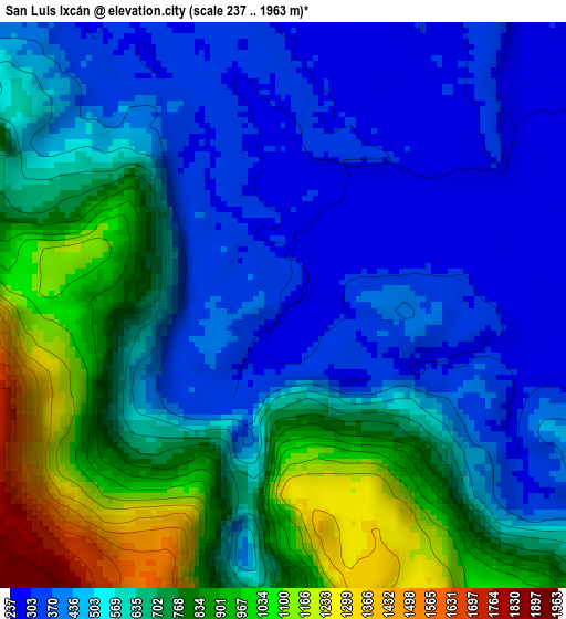
Below is the Elevation map of San Luis Ixcán, which displays elevation range with different colors. Scale of the first map is from 237 to 1963 m (778 to 6440 ft) with average elevation of 615.3 meters (=2019 ft) [note 1]
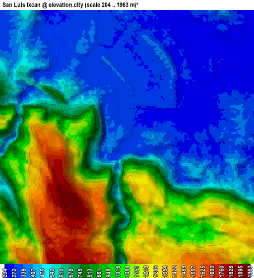
These maps also provides idea of topography and contour of this city, they are displayed at different zoom levels. More info about maps, scale and edge coordinates you can find below images.
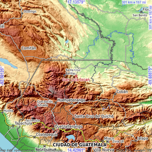
| \ | Map #1 | Map #2 | Topo.Map |
| Scale [m] | 237..1963 m | 204..1963 m | × |
| Scale [ft] | 778..6440 ft | 669..6440 ft | × |
| Average | 615.3 m = 2019 ft | 722.9 m = 2372 ft | × |
| Width | 9.4 km = 5.8 mi | 18.81 km = 11.7 mi | 300.9 km = 187 mi |
| Height | 9.4 km = 5.8 mi | 18.81 km = 11.7 mi | 300.9 km = 187 mi |
| ↑Max Latitude | 15.829503° | 15.871778° | 17.13579° |
| Latitude at center | 15.78722° | 15.78722° | 15.78722° |
| ↓Min Latitude | 15.744928° | 15.702627° | 14.42961° |
| ← Min Longitude | -91.138945° | -91.182891° | -92.50125° |
| Longitude center | -91.095° | -91.095° | -91.095° |
| →Max Longitude | -91.051055° | -91.007109° | -89.68875° |
Nearby cities:
Cities around San Luis Ixcán sort by population:
• Nebaj elevation 1909 m
42.7 km,  187°
187°
• Barillas 1462 m
23.7 km,  274°
274°
• San Mateo Ixtatán 2599 m
41.3 km,  276°
276°
• Chajul 1987 m
34.2 km,  169°
169°
• San Juan Cotzal 1769 m
39.8 km, 170°
• Soloma 2270 m
38.6 km,  248°
248°
• Cunén 1824 m
50.7 km, 171°
• Santa Eulalia 2593 m
39.4 km,  260°
260°
• San Juan Ixcoy 2185 m
43 km,  241°
241°
• San Rafael La Independencia 2518 m
48.1 km, 258°
• San Sebastián Coatán 2357 m
50.4 km, 263°
• Playa Grande 185 m
42 km,  67°
67°
Multilingual:
 En español:
San Luis Ixcán elevación 294 m.
 En France:
San Luis Ixcán élévation 294 m.
 Auf Deutsch:
San Luis Ixcán höhe über dem Meeresspiegel ist 294 m.

Sources and notes:
- [note 1] Map square and city borders are not equal. Map elevation data is calculated only from area inside that square.
- [src 1] Elevation data from geonames database provided with same terms of usage.
- [src 2] The elevation map of San Luis Ixcán is generated using elevation data from NASA's 3 arcsec (90m) resolution SRTM data.
- [src 3] Base (background) map © OpenStreetMap contributors tiles are generated by Geofabrik and OpenTopoMap.
Copyright & License:
This San Luis Ixcán Elevation Map is licensed under CC BY-SA. You may reuse any part from this page, if you give a proper credit by linking to this URL:
 More info on terms of use page.