Cunén elevation
Cunén (Quiché), Guatemala elevation is 1824 meters and Cunén elevation in feet is 5984 ft above sea level [src 1]. Cunén is a seat of a second-order administrative division (feature code) with elevation that is 557 meters (1827 ft) bigger than average city elevation in Guatemala.
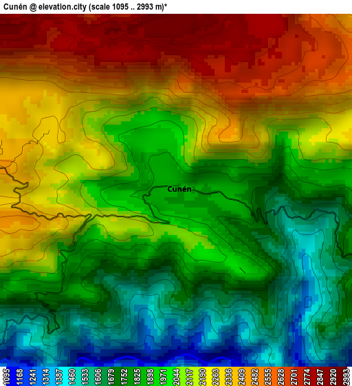
Below is the Elevation map of Cunén, which displays elevation range with different colors. Scale of the first map is from 1095 to 2993 m (3593 to 9820 ft) with average elevation of 2042.4 meters (=6701 ft) [note 1]
These maps also provides idea of topography and contour of this city, they are displayed at different zoom levels. More info about maps, scale and edge coordinates you can find below images.
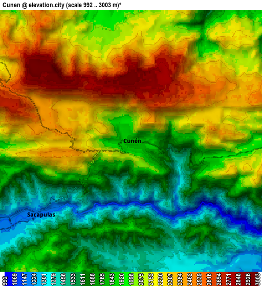
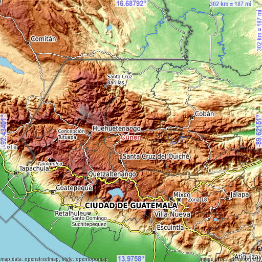
| \ | Map #1 | Map #2 | Topo.Map |
| Scale [m] | 1095..2993 m | 992..3003 m | × |
| Scale [ft] | 3593..9820 ft | 3255..9852 ft | × |
| Average | 2042.4 m = 6701 ft | 1982.3 m = 6504 ft | × |
| Width | 9.42 km = 5.9 mi | 18.85 km = 11.7 mi | 301.6 km = 187.4 mi |
| Height | 9.42 km = 5.9 mi | 18.85 km = 11.7 mi | 301.6 km = 187.4 mi |
| ↑Max Latitude | 15.378636° | 15.421004° | 16.68792° |
| Latitude at center | 15.33626° | 15.33626° | 15.33626° |
| ↓Min Latitude | 15.293875° | 15.251482° | 13.9758° |
| ← Min Longitude | -91.071705° | -91.115651° | -92.43401° |
| Longitude center | -91.02776° | -91.02776° | -91.02776° |
| →Max Longitude | -90.983815° | -90.939869° | -89.62151° |
Nearby cities:
Cities around Cunén sort by population:
• Nebaj elevation 1909 m
14.9 km,  301°
301°
• Sacapulas 1198 m
8.5 km,  230°
230°
• Chajul 1987 m
16.6 km,  357°
357°
• San Juan Cotzal 1769 m
10.9 km, 356°
• Aguacatán 1667 m
30.4 km,  271°
271°
• Uspantán 1812 m
16.9 km,  86°
86°
• Chicamán 1452 m
24.5 km, 86°
• San Andrés Sajcabajá 1252 m
20 km,  152°
152°
• Canillá 1252 m
26.7 km,  135°
135°
• San Bartolomé Jocotenango 1541 m
17 km,  198°
198°
• Santa Lucia La Reforma 1895 m
32.2 km,  224°
224°
• San Pédro Jocopilas 2140 m
29.9 km,  206°
206°
Multilingual:
 En español:
Cunén elevación 1824 m.
 En France:
Cunén élévation 1824 m.


Sources and notes:
- [note 1] Map square and city borders are not equal. Map elevation data is calculated only from area inside that square.
- [src 1] Elevation data from geonames database provided with same terms of usage.
- [src 2] The elevation map of Cunén is generated using elevation data from NASA's 3 arcsec (90m) resolution SRTM data.
- [src 3] Base (background) map © OpenStreetMap contributors tiles are generated by Geofabrik and OpenTopoMap.
Copyright & License:
This Cunén Elevation Map is licensed under CC BY-SA. You may reuse any part from this page, if you give a proper credit by linking to this URL:
 More info on terms of use page.