Uspantán elevation
Uspantán (Quiché), Guatemala elevation is 1812 meters and Uspantán elevation in feet is 5945 ft above sea level [src 1]. Uspantán is a seat of a second-order administrative division (feature code) with elevation that is 545 meters (1788 ft) bigger than average city elevation in Guatemala.
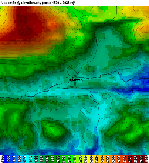
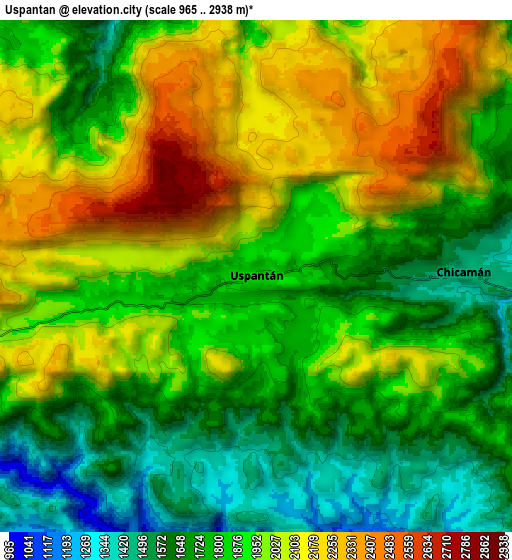
Below is the Elevation map of Uspantán, which displays elevation range with different colors. Scale of the first map is from 1500 to 2938 m (4921 to 9639 ft) with average elevation of 2025.3 meters (=6645 ft) [note 1]
These maps also provides idea of topography and contour of this city, they are displayed at different zoom levels. More info about maps, scale and edge coordinates you can find below images.
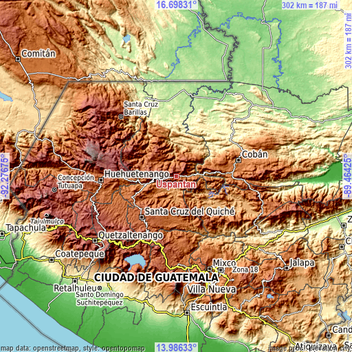
| \ | Map #1 | Map #2 | Topo.Map |
| Scale [m] | 1500..2938 m | 965..2938 m | × |
| Scale [ft] | 4921..9639 ft | 3166..9639 ft | × |
| Average | 2025.3 m = 6645 ft | 1895.4 m = 6219 ft | × |
| Width | 9.42 km = 5.9 mi | 18.85 km = 11.7 mi | 301.5 km = 187.3 mi |
| Height | 9.42 km = 5.9 mi | 18.85 km = 11.7 mi | 301.6 km = 187.4 mi |
| ↑Max Latitude | 15.389094° | 15.431459° | 16.69831° |
| Latitude at center | 15.34672° | 15.34672° | 15.34672° |
| ↓Min Latitude | 15.304337° | 15.261946° | 13.98633° |
| ← Min Longitude | -90.914445° | -90.958391° | -92.27675° |
| Longitude center | -90.8705° | -90.8705° | -90.8705° |
| →Max Longitude | -90.826555° | -90.782609° | -89.46425° |
Nearby cities:
Cities around Uspantán sort by population:
• Nebaj elevation 1909 m
30.4 km,  282°
282°
• San Cristóbal Verapaz 2149 m
33.2 km,  80°
80°
• Sacapulas 1198 m
24.3 km,  254°
254°
• Chajul 1987 m
23.4 km,  311°
311°
• San Juan Cotzal 1769 m
20.1 km,  298°
298°
• Cubulco 1015 m
37.4 km,  136°
136°
• Zacualpa 1497 m
35.6 km,  181°
181°
• Cunén 1824 m
16.9 km,  266°
266°
• Chicamán 1452 m
7.6 km,  89°
89°
• San Andrés Sajcabajá 1252 m
20.5 km,  202°
202°
• Canillá 1252 m
20.2 km,  174°
174°
• San Bartolomé Jocotenango 1541 m
28.2 km,  232°
232°
Multilingual:
 En español:
Uspantán elevación 1812 m.
 En France:
Uspantán élévation 1812 m.
 Auf Deutsch:
Uspantán höhe über dem Meeresspiegel ist 1812 m.

Sources and notes:
- [note 1] Map square and city borders are not equal. Map elevation data is calculated only from area inside that square.
- [src 1] Elevation data from geonames database provided with same terms of usage.
- [src 2] The elevation map of Uspantán is generated using elevation data from NASA's 3 arcsec (90m) resolution SRTM data.
- [src 3] Base (background) map © OpenStreetMap contributors tiles are generated by Geofabrik and OpenTopoMap.
Copyright & License:
This Uspantán Elevation Map is licensed under CC BY-SA. You may reuse any part from this page, if you give a proper credit by linking to this URL:
 More info on terms of use page.