San Mateo Ixtatán elevation
San Mateo Ixtatán (Huehuetenango), Guatemala elevation is 2599 meters and San Mateo Ixtatán elevation in feet is 8527 ft above sea level [src 1]. San Mateo Ixtatán is a seat of a second-order administrative division (feature code) with elevation that is 1332 meters (4370 ft) bigger than average city elevation in Guatemala.
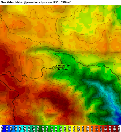
Below is the Elevation map of San Mateo Ixtatán, which displays elevation range with different colors. Scale of the first map is from 1756 to 3310 m (5761 to 10860 ft) with average elevation of 2750 meters (=9022 ft) [note 1]
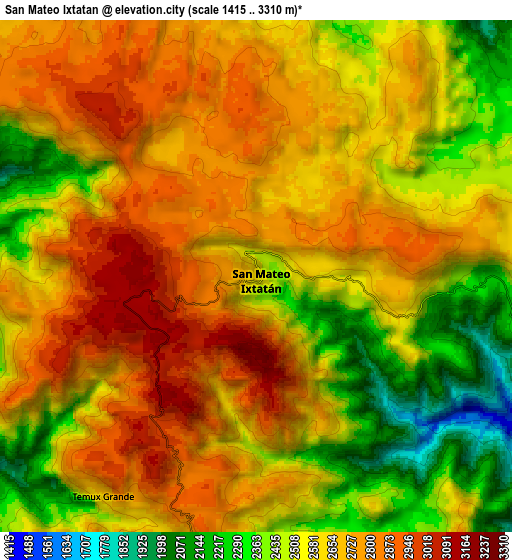
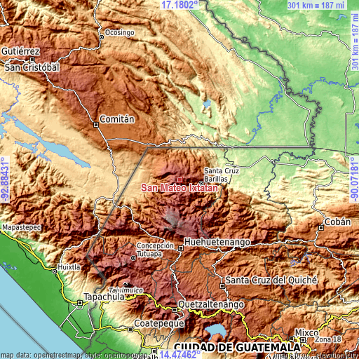
These maps also provides idea of topography and contour of this city, they are displayed at different zoom levels. More info about maps, scale and edge coordinates you can find below images.
| \ | Map #1 | Map #2 | Topo.Map |
| Scale [m] | 1756..3310 m | 1415..3310 m | × |
| Scale [ft] | 5761..10860 ft | 4642..10860 ft | × |
| Average | 2750 m = 9022 ft | 2612.4 m = 8571 ft | × |
| Width | 9.4 km = 5.8 mi | 18.8 km = 11.7 mi | 300.8 km = 186.9 mi |
| Height | 9.4 km = 5.8 mi | 18.8 km = 11.7 mi | 300.9 km = 187 mi |
| ↑Max Latitude | 15.874214° | 15.916479° | 17.1802° |
| Latitude at center | 15.83194° | 15.83194° | 15.83194° |
| ↓Min Latitude | 15.789657° | 15.747366° | 14.47462° |
| ← Min Longitude | -91.522005° | -91.565951° | -92.88431° |
| Longitude center | -91.47806° | -91.47806° | -91.47806° |
| →Max Longitude | -91.434115° | -91.390169° | -90.07181° |
Nearby cities:
Cities around San Mateo Ixtatán sort by population:
• Jacaltenango elevation 1459 m
31 km,  233°
233°
• Barillas 1462 m
17.6 km,  100°
100°
• Soloma 2270 m
20 km,  165°
165°
• Concepción Huista 2238 m
30.6 km,  220°
220°
• San Antonio Huista 1243 m
37.4 km,  237°
237°
• Santa Eulalia 2593 m
11.5 km, 169°
• San Miguel Acatán 1792 m
19.1 km, 221°
• San Juan Ixcoy 2185 m
26 km, 172°
• Nentón 775 m
29.8 km,  263°
263°
• San Rafael La Independencia 2518 m
15.8 km,  202°
202°
• San Sebastián Coatán 2357 m
14 km, 220°
• Unión 892 m
33.4 km,  287°
287°
Multilingual:
 En español:
San Mateo Ixtatán elevación 2599 m.
 En France:
San Mateo Ixtatán élévation 2599 m.
 Auf Deutsch:
San Mateo Ixtatán höhe über dem Meeresspiegel ist 2599 m.
 На русском:
San Mateo Ixtatán высота над уровнем моря 2599 м
Sources and notes:
- [note 1] Map square and city borders are not equal. Map elevation data is calculated only from area inside that square.
- [src 1] Elevation data from geonames database provided with same terms of usage.
- [src 2] The elevation map of San Mateo Ixtatán is generated using elevation data from NASA's 3 arcsec (90m) resolution SRTM data.
- [src 3] Base (background) map © OpenStreetMap contributors tiles are generated by Geofabrik and OpenTopoMap.
Copyright & License:
This San Mateo Ixtatán Elevation Map is licensed under CC BY-SA. You may reuse any part from this page, if you give a proper credit by linking to this URL:
 More info on terms of use page.