Unión elevation
Unión (Huehuetenango), Guatemala elevation is 892 meters and Unión elevation in feet is 2927 ft above sea level [src 1]. Unión is a seat of a second-order administrative division (feature code) with elevation that is 375 meters (1230 ft) smaller than average city elevation in Guatemala.
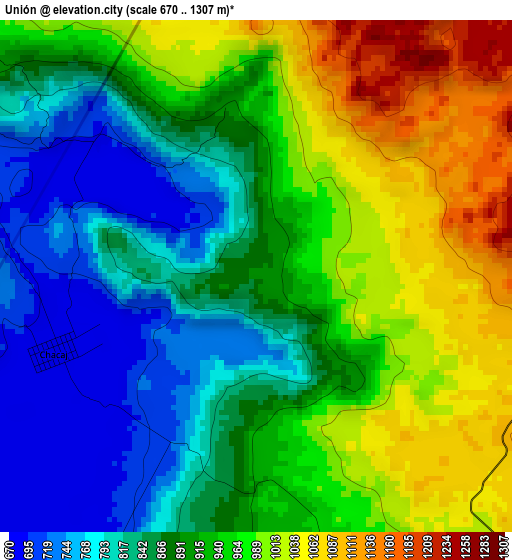
Below is the Elevation map of Unión, which displays elevation range with different colors. Scale of the first map is from 670 to 1307 m (2198 to 4288 ft) with average elevation of 911.2 meters (=2990 ft) [note 1]
These maps also provides idea of topography and contour of this city, they are displayed at different zoom levels. More info about maps, scale and edge coordinates you can find below images.
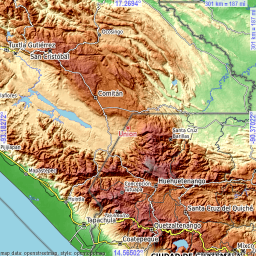
| \ | Map #1 | Topo.Map |
| Scale [m] | 670..1307 m | × |
| Scale [ft] | 2198..4288 ft | × |
| Average | 911.2 m = 2990 ft | × |
| Width | 9.4 km = 5.8 mi | 300.7 km = 186.8 mi |
| Height | 9.4 km = 5.8 mi | 300.7 km = 186.8 mi |
| ↑Max Latitude | 15.964015° | 17.2694° |
| Latitude at center | 15.92176° | 15.92176° |
| ↓Min Latitude | 15.879496° | 14.56502° |
| ← Min Longitude | -91.820415° | -93.18272° |
| Longitude center | -91.77647° | -91.77647° |
| →Max Longitude | -91.732525° | -90.37022° |
Nearby cities:
Cities around Unión sort by population:
• Jacaltenango elevation 1459 m
29.2 km,  166°
166°
• San Mateo Ixtatán 2599 m
33.4 km,  107°
107°
• Concepción Huista 2238 m
35.2 km,  160°
160°
• La Libertad 1710 m
46.4 km,  192°
192°
• San Antonio Huista 1243 m
30.2 km,  179°
179°
• Santa Eulalia 2593 m
40.1 km,  121°
121°
• San Miguel Acatán 1792 m
30.9 km,  141°
141°
• Nentón 775 m
13.7 km, 170°
• Santa Ana Huista 754 m
27.2 km, 189°
• San Rafael La Independencia 2518 m
35.6 km,  133°
133°
• San Sebastián Coatán 2357 m
30.8 km, 132°
• La Democracia 928 m
35 km,  199°
199°
Multilingual:
 En español:
Unión elevación 892 m.
 En France:
Unión élévation 892 m.


Sources and notes:
- [note 1] Map square and city borders are not equal. Map elevation data is calculated only from area inside that square.
- [src 1] Elevation data from geonames database provided with same terms of usage.
- [src 2] The elevation map of Unión is generated using elevation data from NASA's 3 arcsec (90m) resolution SRTM data.
- [src 3] Base (background) map © OpenStreetMap contributors tiles are generated by Geofabrik and OpenTopoMap.
Copyright & License:
This Unión Elevation Map is licensed under CC BY-SA. You may reuse any part from this page, if you give a proper credit by linking to this URL:
 More info on terms of use page.