Jacaltenango elevation
Jacaltenango (Huehuetenango), Guatemala elevation is 1459 meters and Jacaltenango elevation in feet is 4787 ft above sea level [src 1]. Jacaltenango is a seat of a second-order administrative division (feature code) with elevation that is 192 meters (630 ft) bigger than average city elevation in Guatemala.
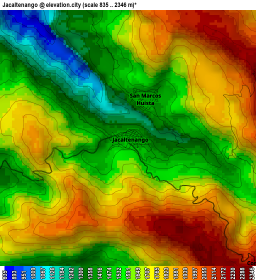
Below is the Elevation map of Jacaltenango, which displays elevation range with different colors. Scale of the first map is from 835 to 2346 m (2740 to 7697 ft) with average elevation of 1660.9 meters (=5449 ft) [note 1]
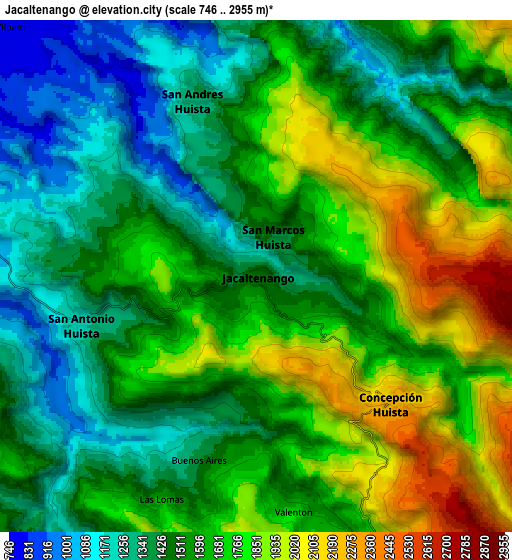
These maps also provides idea of topography and contour of this city, they are displayed at different zoom levels. More info about maps, scale and edge coordinates you can find below images.
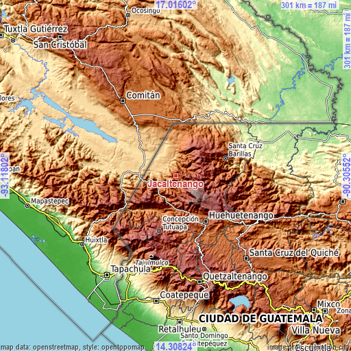
| \ | Map #1 | Map #2 | Topo.Map |
| Scale [m] | 835..2346 m | 746..2955 m | × |
| Scale [ft] | 2740..7697 ft | 2448..9695 ft | × |
| Average | 1660.9 m = 5449 ft | 1599.3 m = 5247 ft | × |
| Width | 9.41 km = 5.8 mi | 18.82 km = 11.7 mi | 301.1 km = 187.1 mi |
| Height | 9.41 km = 5.8 mi | 18.82 km = 11.7 mi | 301.1 km = 187.1 mi |
| ↑Max Latitude | 15.708928° | 15.751228° | 17.01602° |
| Latitude at center | 15.66662° | 15.66662° | 15.66662° |
| ↓Min Latitude | 15.624303° | 15.581977° | 14.30824° |
| ← Min Longitude | -91.755715° | -91.799661° | -93.11802° |
| Longitude center | -91.71177° | -91.71177° | -91.71177° |
| →Max Longitude | -91.667825° | -91.623879° | -90.30552° |
Nearby cities:
Cities around Jacaltenango sort by population:
• Concepción Huista elevation 2238 m
6.9 km,  133°
133°
• La Libertad 1710 m
23.9 km,  224°
224°
• San Antonio Huista 1243 m
6.7 km,  254°
254°
• San Pedro Necta 1513 m
20.3 km,  196°
196°
• Todos Santos Cuchumatán 2500 m
21 km,  146°
146°
• Santiago Chimaltenango 2246 m
21.2 km,  175°
175°
• San Miguel Acatán 1792 m
12.9 km,  71°
71°
• Nentón 775 m
15.6 km,  342°
342°
• Santa Ana Huista 754 m
11.7 km,  277°
277°
• San Rafael La Independencia 2518 m
19.3 km,  78°
78°
• San Sebastián Coatán 2357 m
17.7 km,  64°
64°
• La Democracia 928 m
19.3 km,  256°
256°
Multilingual:
 En español:
Jacaltenango elevación 1459 m.
 En France:
Jacaltenango élévation 1459 m.
 Auf Deutsch:
Jacaltenango höhe über dem Meeresspiegel ist 1459 m.

Sources and notes:
- [note 1] Map square and city borders are not equal. Map elevation data is calculated only from area inside that square.
- [src 1] Elevation data from geonames database provided with same terms of usage.
- [src 2] The elevation map of Jacaltenango is generated using elevation data from NASA's 3 arcsec (90m) resolution SRTM data.
- [src 3] Base (background) map © OpenStreetMap contributors tiles are generated by Geofabrik and OpenTopoMap.
Copyright & License:
This Jacaltenango Elevation Map is licensed under CC BY-SA. You may reuse any part from this page, if you give a proper credit by linking to this URL:
 More info on terms of use page.