Vani elevation
Vani (Imereti), Georgia elevation is 70 meters and Vani elevation in feet is 230 ft above sea level [src 1]. Vani is a populated place (feature code) with elevation that is 470 meters (1542 ft) smaller than average city elevation in Georgia.
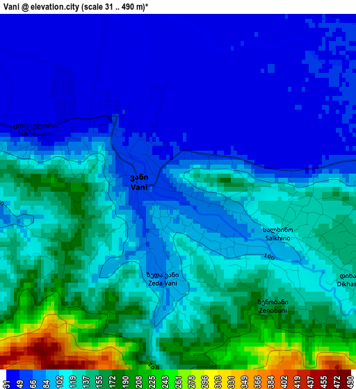
Below is the Elevation map of Vani, which displays elevation range with different colors. Scale of the first map is from 31 to 490 m (102 to 1608 ft) with average elevation of 109.1 meters (=358 ft) [note 1]
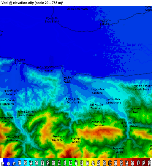
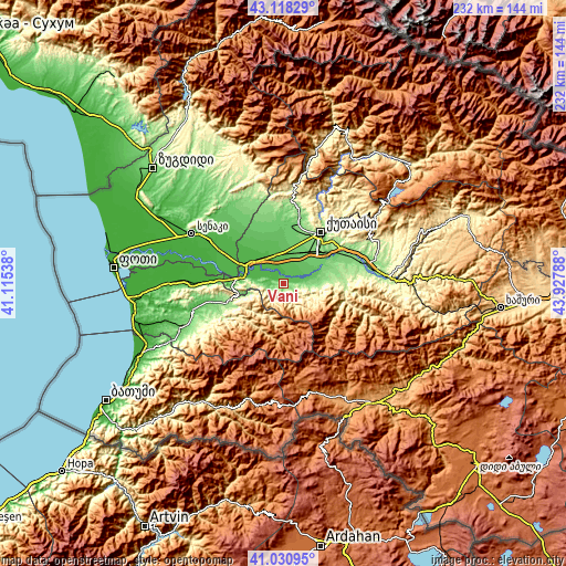
These maps also provides idea of topography and contour of this city, they are displayed at different zoom levels. More info about maps, scale and edge coordinates you can find below images.
| \ | Map #1 | Map #2 | Topo.Map |
| Scale [m] | 31..490 m | 20..785 m | × |
| Scale [ft] | 102..1608 ft | 66..2575 ft | × |
| Average | 109.1 m = 358 ft | 161.7 m = 531 ft | × |
| Width | 7.25 km = 4.5 mi | 14.51 km = 9 mi | 232.1 km = 144.2 mi |
| Height | 7.25 km = 4.5 mi | 14.51 km = 9 mi | 232.1 km = 144.2 mi |
| ↑Max Latitude | 42.115807° | 42.148396° | 43.11829° |
| Latitude at center | 42.0832° | 42.0832° | 42.0832° |
| ↓Min Latitude | 42.050577° | 42.017936° | 41.03095° |
| ← Min Longitude | 42.477685° | 42.433739° | 41.11538° |
| Longitude center | 42.52163° | 42.52163° | 42.52163° |
| →Max Longitude | 42.565575° | 42.609521° | 43.92788° |
Nearby cities:
Cities around Vani sort by population:
• Kutaisi elevation 153 m
25 km,  34°
34°
• Samtredia 23 m
17.3 km,  297°
297°
• Senak’i 36 m
42.8 km, 299°
• Zestap’oni 201 m
43.9 km,  86°
86°
• Ozurgeti 84 m
46.1 km,  247°
247°
• Tsqaltubo 142 m
29.4 km,  12°
12°
• Khoni 118 m
27.9 km,  342°
342°
• Abasha 26 m
28.5 km, 299°
• Mart’vili 194 m
38.6 km, 342°
• K’ulashi 38 m
19.9 km,  312°
312°
• Shorapani 273 m
46.6 km, 89°
• Lanchkhuti 22 m
40.4 km,  271°
271°
Multilingual:
 En español:
Vani elevación 70 m.
 En France:
Vani élévation 70 m.


Sources and notes:
- [note 1] Map square and city borders are not equal. Map elevation data is calculated only from area inside that square.
- [src 1] Elevation data from geonames database provided with same terms of usage.
- [src 2] The elevation map of Vani is generated using elevation data from NASA's 3 arcsec (90m) resolution SRTM data.
- [src 3] Base (background) map © OpenStreetMap contributors tiles are generated by Geofabrik and OpenTopoMap.
Copyright & License:
This Vani Elevation Map is licensed under CC BY-SA. You may reuse any part from this page, if you give a proper credit by linking to this URL:
 More info on terms of use page.