Ozurgeti elevation
Ozurgeti (Guria), Georgia elevation is 84 meters and Ozurgeti elevation in feet is 276 ft above sea level [src 1]. Ozurgeti is a seat of a first-order administrative division (feature code) with elevation that is 456 meters (1496 ft) smaller than average city elevation in Georgia.
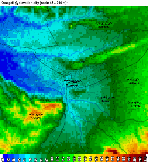
Below is the Elevation map of Ozurgeti, which displays elevation range with different colors. Scale of the first map is from 45 to 214 m (148 to 702 ft) with average elevation of 97.7 meters (=321 ft) [note 1]
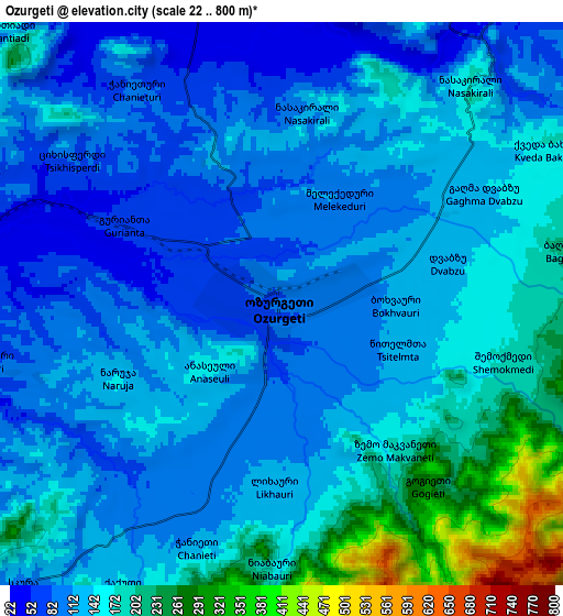
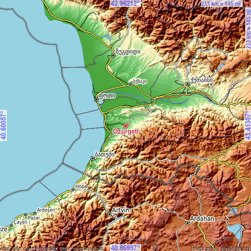
These maps also provides idea of topography and contour of this city, they are displayed at different zoom levels. More info about maps, scale and edge coordinates you can find below images.
| \ | Map #1 | Map #2 | Topo.Map |
| Scale [m] | 45..214 m | 22..800 m | × |
| Scale [ft] | 148..702 ft | 72..2625 ft | × |
| Average | 97.7 m = 321 ft | 140.8 m = 462 ft | × |
| Width | 7.27 km = 4.5 mi | 14.54 km = 9 mi | 232.7 km = 144.6 mi |
| Height | 7.27 km = 4.5 mi | 14.54 km = 9 mi | 232.7 km = 144.6 mi |
| ↑Max Latitude | 41.957108° | 41.989779° | 42.96212° |
| Latitude at center | 41.92442° | 41.92442° | 41.92442° |
| ↓Min Latitude | 41.891715° | 41.858994° | 40.86957° |
| ← Min Longitude | 41.962875° | 41.918929° | 40.60057° |
| Longitude center | 42.00682° | 42.00682° | 42.00682° |
| →Max Longitude | 42.050765° | 42.094711° | 43.41307° |
Nearby cities:
Cities around Ozurgeti sort by population:
• P’ot’i elevation 1 m
37 km,  311°
311°
• Kobuleti 3 m
22.1 km,  238°
238°
• Chakvi 19 m
31.7 km,  225°
225°
• Abasha 26 m
36.3 km,  29°
29°
• Akhaldaba 748 m
32.4 km,  158°
158°
• Naruja 144 m
4.8 km,  245°
245°
• Ochkhamuri 22 m
14.6 km, 240°
• Urek’i 6 m
20.5 km,  292°
292°
• Tsikhisdziri 71 m
27.2 km, 229°
• Shuakhevi 572 m
36.1 km, 155°
• Keda 305 m
36.4 km,  188°
188°
• Lanchkhuti 22 m
18.6 km,  6°
6°
Multilingual:
 En español:
Ozurgueti elevación 84 m.
 En France:
Ozourguéti élévation 84 m.


Sources and notes:
- [note 1] Map square and city borders are not equal. Map elevation data is calculated only from area inside that square.
- [src 1] Elevation data from geonames database provided with same terms of usage.
- [src 2] The elevation map of Ozurgeti is generated using elevation data from NASA's 3 arcsec (90m) resolution SRTM data.
- [src 3] Base (background) map © OpenStreetMap contributors tiles are generated by Geofabrik and OpenTopoMap.
Copyright & License:
This Ozurgeti Elevation Map is licensed under CC BY-SA. You may reuse any part from this page, if you give a proper credit by linking to this URL:
 More info on terms of use page.