Zestap’oni elevation
Zestap’oni (Imereti), Georgia elevation is 201 meters and Zestap’oni elevation in feet is 659 ft above sea level [src 1]. Zestap’oni is a seat of a second-order administrative division (feature code) with elevation that is 339 meters (1112 ft) smaller than average city elevation in Georgia.
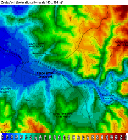
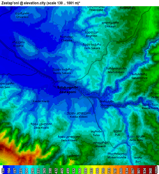
Below is the Elevation map of Zestap’oni, which displays elevation range with different colors. Scale of the first map is from 143 to 394 m (469 to 1293 ft) with average elevation of 234.5 meters (=769 ft) [note 1]
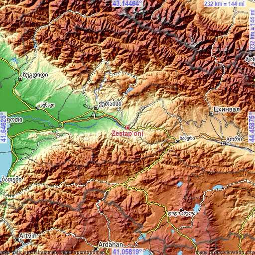
These maps also provides idea of topography and contour of this city, they are displayed at different zoom levels. More info about maps, scale and edge coordinates you can find below images.
| \ | Map #1 | Map #2 | Topo.Map |
| Scale [m] | 143..394 m | 130..1001 m | × |
| Scale [ft] | 469..1293 ft | 427..3284 ft | × |
| Average | 234.5 m = 769 ft | 299.8 m = 984 ft | × |
| Width | 7.25 km = 4.5 mi | 14.5 km = 9 mi | 232 km = 144.2 mi |
| Height | 7.25 km = 4.5 mi | 14.5 km = 9 mi | 232 km = 144.2 mi |
| ↑Max Latitude | 42.142593° | 42.175169° | 43.14464° |
| Latitude at center | 42.11° | 42.11° | 42.11° |
| ↓Min Latitude | 42.07739° | 42.044764° | 41.05819° |
| ← Min Longitude | 43.008555° | 42.964609° | 41.64625° |
| Longitude center | 43.0525° | 43.0525° | 43.0525° |
| →Max Longitude | 43.096445° | 43.140391° | 44.45875° |
Nearby cities:
Cities around Zestap’oni sort by population:
• Kutaisi elevation 153 m
34.3 km,  300°
300°
• Tsqaltubo 142 m
45.4 km, 304°
• Borjomi 810 m
41.3 km,  133°
133°
• Tqibuli 565 m
27.2 km,  350°
350°
• Chiat’ura 495 m
29.1 km,  44°
44°
• Surami 745 m
42.6 km,  102°
102°
• Sach’khere 484 m
40 km,  49°
49°
• Vani 70 m
43.9 km,  266°
266°
• Akhaldaba 742 m
41.2 km,  119°
119°
• Kats’khi 638 m
24 km,  32°
32°
• Shorapani 273 m
3.6 km, 128°
• Kharagauli 310 m
15.5 km, 129°
Multilingual:
 En español:
Zestap’oni elevación 201 m.
 En France:
Zestap’oni élévation 201 m.
 Auf Deutsch:
Zestap’oni höhe über dem Meeresspiegel ist 201 m.

Sources and notes:
- [note 1] Map square and city borders are not equal. Map elevation data is calculated only from area inside that square.
- [src 1] Elevation data from geonames database provided with same terms of usage.
- [src 2] The elevation map of Zestap’oni is generated using elevation data from NASA's 3 arcsec (90m) resolution SRTM data.
- [src 3] Base (background) map © OpenStreetMap contributors tiles are generated by Geofabrik and OpenTopoMap.
Copyright & License:
This Zestap’oni Elevation Map is licensed under CC BY-SA. You may reuse any part from this page, if you give a proper credit by linking to this URL:
 More info on terms of use page.