Chiat’ura elevation
Chiat’ura (Imereti), Georgia elevation is 495 meters and Chiat’ura elevation in feet is 1624 ft above sea level [src 1]. Chiat’ura is a populated place (feature code) with elevation that is 45 meters (148 ft) smaller than average city elevation in Georgia.
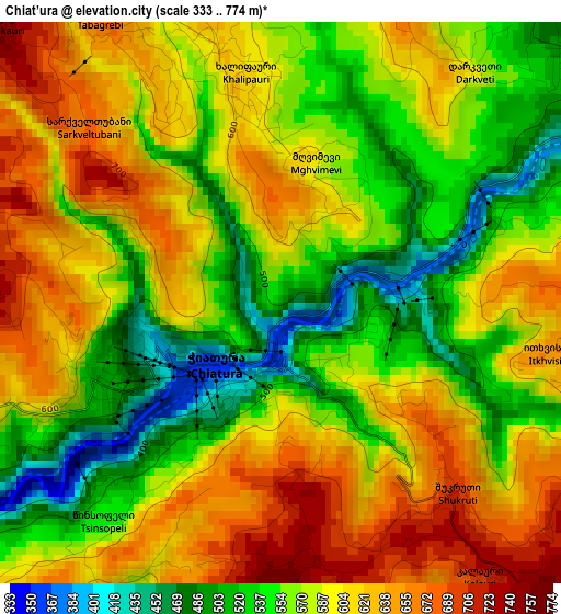
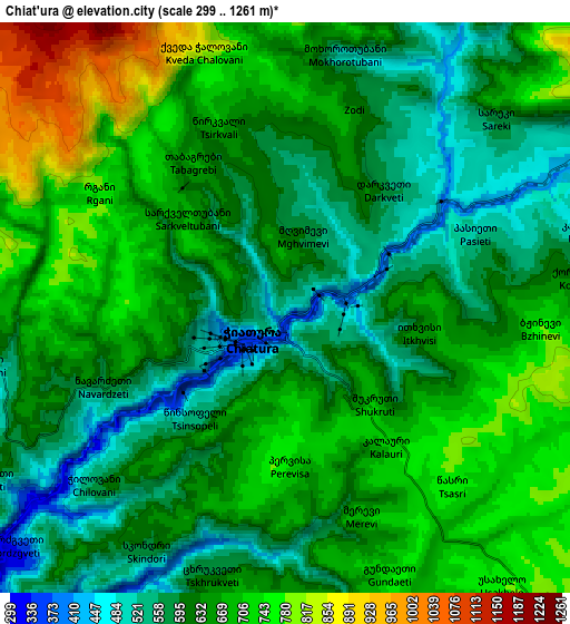
Below is the Elevation map of Chiat’ura, which displays elevation range with different colors. Scale of the first map is from 333 to 774 m (1093 to 2539 ft) with average elevation of 581.7 meters (=1908 ft) [note 1]
These maps also provides idea of topography and contour of this city, they are displayed at different zoom levels. More info about maps, scale and edge coordinates you can find below images.
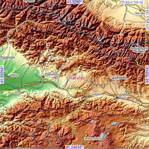
| \ | Map #1 | Map #2 | Topo.Map |
| Scale [m] | 333..774 m | 299..1261 m | × |
| Scale [ft] | 1093..2539 ft | 981..4137 ft | × |
| Average | 581.7 m = 1908 ft | 645.9 m = 2119 ft | × |
| Width | 7.23 km = 4.5 mi | 14.46 km = 9 mi | 231.3 km = 143.7 mi |
| Height | 7.23 km = 4.5 mi | 14.46 km = 9 mi | 231.3 km = 143.7 mi |
| ↑Max Latitude | 42.330556° | 42.363035° | 43.3296° |
| Latitude at center | 42.29806° | 42.29806° | 42.29806° |
| ↓Min Latitude | 42.265547° | 42.233018° | 41.24934° |
| ← Min Longitude | 43.254945° | 43.210999° | 41.89264° |
| Longitude center | 43.29889° | 43.29889° | 43.29889° |
| →Max Longitude | 43.342835° | 43.386781° | 44.70514° |
Nearby cities:
Cities around Chiat’ura sort by population:
• Khashuri elevation 700 m
41.9 km,  143°
143°
• Zestap’oni 201 m
29.1 km,  224°
224°
• Tqibuli 565 m
25.4 km,  283°
283°
• Surami 745 m
37.1 km,  145°
145°
• Sach’khere 484 m
11.2 km,  62°
62°
• Oni 838 m
33.4 km,  20°
20°
• Ambrolauri 609 m
27.2 km,  335°
335°
• Akhaldaba 742 m
43.8 km,  159°
159°
• Kats’khi 638 m
7.4 km,  265°
265°
• Shorapani 273 m
29 km, 217°
• Kharagauli 310 m
31.9 km,  195°
195°
• Gori 705 m
26.6 km, 335°
Multilingual:
 En español:
Chiat’ura elevación 495 m.
 En France:
Chiat’ura élévation 495 m.
 Auf Deutsch:
Chiat’ura höhe über dem Meeresspiegel ist 495 m.

Sources and notes:
- [note 1] Map square and city borders are not equal. Map elevation data is calculated only from area inside that square.
- [src 1] Elevation data from geonames database provided with same terms of usage.
- [src 2] The elevation map of Chiat’ura is generated using elevation data from NASA's 3 arcsec (90m) resolution SRTM data.
- [src 3] Base (background) map © OpenStreetMap contributors tiles are generated by Geofabrik and OpenTopoMap.
Copyright & License:
This Chiat’ura Elevation Map is licensed under CC BY-SA. You may reuse any part from this page, if you give a proper credit by linking to this URL:
 More info on terms of use page.