Pontyclun elevation
Pontyclun (Wales, Rhondda Cynon Taf), United Kingdom elevation is 49 meters and Pontyclun elevation in feet is 161 ft above sea level [src 1]. Pontyclun is a populated place (feature code) with elevation that is 23 meters (75 ft) smaller than average city elevation in United Kingdom.
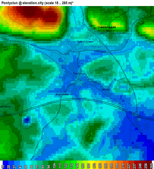
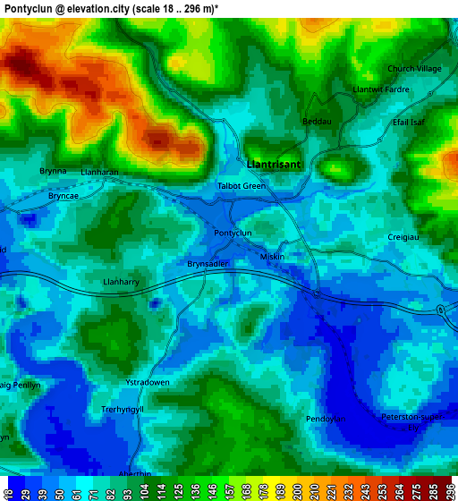
Below is the Elevation map of Pontyclun, which displays elevation range with different colors. Scale of the first map is from 18 to 265 m (59 to 869 ft) with average elevation of 78.2 meters (=257 ft) [note 1]
These maps also provides idea of topography and contour of this city, they are displayed at different zoom levels. More info about maps, scale and edge coordinates you can find below images.
| \ | Map #1 | Map #2 | Topo.Map |
| Scale [m] | 18..265 m | 18..296 m | × |
| Scale [ft] | 59..869 ft | 59..971 ft | × |
| Average | 78.2 m = 257 ft | 93.4 m = 306 ft | × |
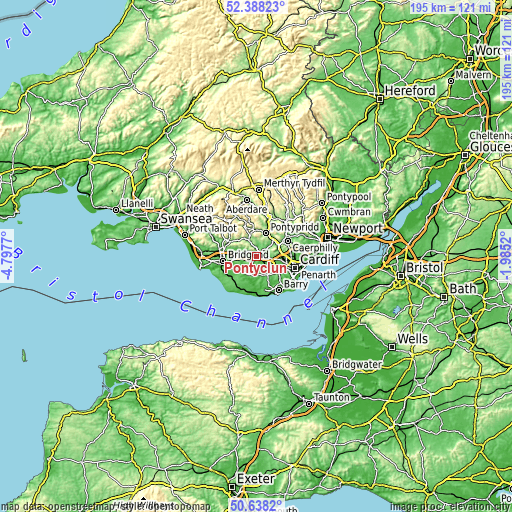
| Width | 6.08 km = 3.8 mi | 12.16 km = 7.6 mi | 194.6 km = 120.9 mi |
| Height | 6.08 km = 3.8 mi | 12.16 km = 7.6 mi | 194.6 km = 120.9 mi |
| ↑Max Latitude | 51.548955° | 51.576274° | 52.38823° |
| Latitude at center | 51.52162° | 51.52162° | 51.52162° |
| ↓Min Latitude | 51.494268° | 51.4669° | 50.6382° |
| ← Min Longitude | -3.435395° | -3.479341° | -4.7977° |
| Longitude center | -3.39145° | -3.39145° | -3.39145° |
| →Max Longitude | -3.347505° | -3.303559° | -1.9852° |
Nearby cities:
Cities around Pontyclun sort by population:
• Llantrisant elevation 101 m
2.4 km,  30°
30°
• Tonyrefail 143 m
7.4 km,  338°
338°
• Pencoed 33 m
7.5 km,  271°
271°
• Beddau 116 m
4.3 km, 32°
• Brynna 80 m
5.3 km,  290°
290°
• Llanharan 76 m
3.8 km,  299°
299°
• Llantwit Fardre 76 m
5.5 km,  48°
48°
• Cowbridge 35 m
7.7 km,  207°
207°
• Llanharry 90 m
3 km,  253°
253°
• Pentyrch 142 m
6.7 km,  83°
83°
• Llangan 42 m
8.5 km,  242°
242°
• Penllyn 95 m
8 km,  229°
229°
Multilingual:
 En español:
Pontyclun elevación 49 m.
 En France:
Pontyclun élévation 49 m.
 Auf Deutsch:
Pontyclun höhe über dem Meeresspiegel ist 49 m.

Sources and notes:
- [note 1] Map square and city borders are not equal. Map elevation data is calculated only from area inside that square.
- [src 1] Elevation data from geonames database provided with same terms of usage.
- [src 2] The elevation map of Pontyclun is generated using elevation data from NASA's 3 arcsec (90m) resolution SRTM data.
- [src 3] Base (background) map © OpenStreetMap contributors tiles are generated by Geofabrik and OpenTopoMap.
Copyright & License:
This Pontyclun Elevation Map is licensed under CC BY-SA. You may reuse any part from this page, if you give a proper credit by linking to this URL:
 More info on terms of use page.