Donnington elevation
Donnington (England, Gloucestershire), United Kingdom elevation is 194 meters and Donnington elevation in feet is 636 ft above sea level [src 1]. Donnington is a populated place (feature code) with elevation that is 122 meters (400 ft) bigger than average city elevation in United Kingdom.
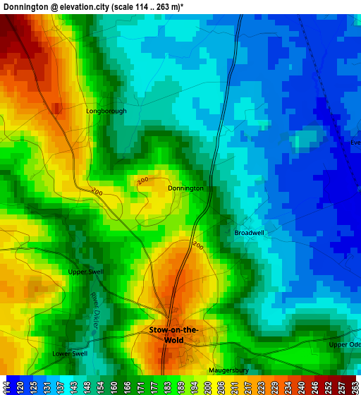
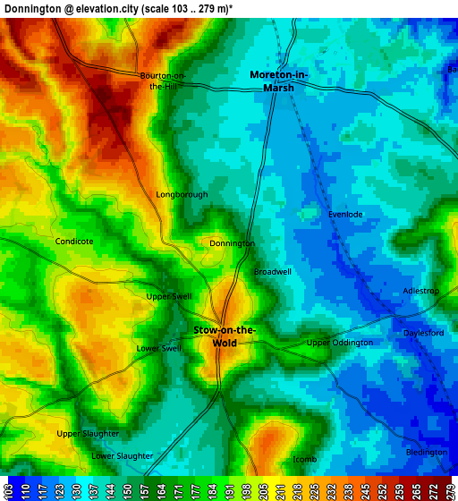
Below is the Elevation map of Donnington, which displays elevation range with different colors. Scale of the first map is from 114 to 263 m (374 to 863 ft) with average elevation of 166.6 meters (=547 ft) [note 1]
These maps also provides idea of topography and contour of this city, they are displayed at different zoom levels. More info about maps, scale and edge coordinates you can find below images.
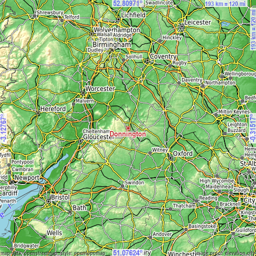
| \ | Map #1 | Map #2 | Topo.Map |
| Scale [m] | 114..263 m | 103..279 m | × |
| Scale [ft] | 374..863 ft | 338..915 ft | × |
| Average | 166.6 m = 547 ft | 167.3 m = 549 ft | × |
| Width | 6.02 km = 3.7 mi | 12.05 km = 7.5 mi | 192.7 km = 119.7 mi |
| Height | 6.02 km = 3.7 mi | 12.05 km = 7.5 mi | 192.7 km = 119.7 mi |
| ↑Max Latitude | 51.978427° | 52.005487° | 52.80971° |
| Latitude at center | 51.95135° | 51.95135° | 51.95135° |
| ↓Min Latitude | 51.924257° | 51.897148° | 51.07624° |
| ← Min Longitude | -1.765365° | -1.809311° | -3.12767° |
| Longitude center | -1.72142° | -1.72142° | -1.72142° |
| →Max Longitude | -1.677475° | -1.633529° | -0.31517° |
Nearby cities:
Cities around Donnington sort by population:
• Chipping Norton elevation 205 m
12.1 km,  95°
95°
• Shipston on Stour 72 m
13.7 km,  27°
27°
• Moreton in Marsh 129 m
4.4 km,  16°
16°
• Bourton on the Water 135 m
7.6 km,  197°
197°
• Shipton under Wychwood 104 m
13.2 km,  140°
140°
• Broadway 94 m
13.6 km,  315°
315°
• Chipping Campden 139 m
11.6 km,  340°
340°
• Stow on the Wold 235 m
2.4 km,  183°
183°
• Northleach 167 m
15.7 km,  210°
210°
• Mickleton 75 m
15.9 km,  348°
348°
• Westfield 217 m
12.5 km,  232°
232°
• Blockley 156 m
7.3 km, 337°
Multilingual:
 En español:
Donnington elevación 194 m.
 En France:
Donnington élévation 194 m.
 Auf Deutsch:
Donnington höhe über dem Meeresspiegel ist 194 m.

Sources and notes:
- [note 1] Map square and city borders are not equal. Map elevation data is calculated only from area inside that square.
- [src 1] Elevation data from geonames database provided with same terms of usage.
- [src 2] The elevation map of Donnington is generated using elevation data from NASA's 3 arcsec (90m) resolution SRTM data.
- [src 3] Base (background) map © OpenStreetMap contributors tiles are generated by Geofabrik and OpenTopoMap.
Copyright & License:
This Donnington Elevation Map is licensed under CC BY-SA. You may reuse any part from this page, if you give a proper credit by linking to this URL:
 More info on terms of use page.