Northleach elevation
Northleach (England, Gloucestershire), United Kingdom elevation is 167 meters and Northleach elevation in feet is 548 ft above sea level [src 1]. Northleach is a populated place (feature code) with elevation that is 95 meters (312 ft) bigger than average city elevation in United Kingdom.
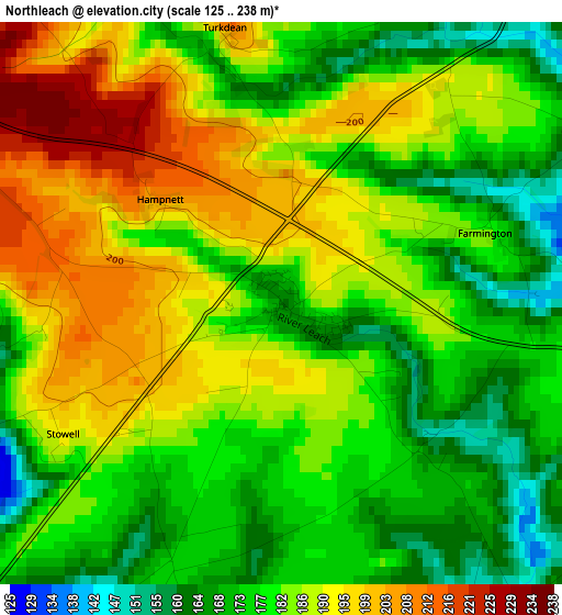
Below is the Elevation map of Northleach, which displays elevation range with different colors. Scale of the first map is from 125 to 238 m (410 to 781 ft) with average elevation of 182.7 meters (=599 ft) [note 1]
These maps also provides idea of topography and contour of this city, they are displayed at different zoom levels. More info about maps, scale and edge coordinates you can find below images.
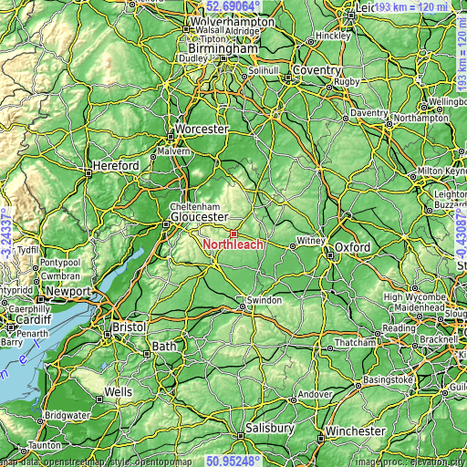
| \ | Map #1 | Topo.Map |
| Scale [m] | 125..238 m | × |
| Scale [ft] | 410..781 ft | × |
| Average | 182.7 m = 599 ft | × |
| Width | 6.04 km = 3.8 mi | 193.3 km = 120.1 mi |
| Height | 6.04 km = 3.8 mi | 193.2 km = 120 mi |
| ↑Max Latitude | 51.85709° | 52.69064° |
| Latitude at center | 51.82994° | 51.82994° |
| ↓Min Latitude | 51.802774° | 50.95248° |
| ← Min Longitude | -1.881065° | -3.24337° |
| Longitude center | -1.83712° | -1.83712° |
| →Max Longitude | -1.793175° | -0.43087° |
Nearby cities:
Cities around Northleach sort by population:
• Cirencester elevation 112 m
15.4 km,  216°
216°
• Charlton Kings 95 m
15.3 km,  292°
292°
• Winchcombe 93 m
16.3 km,  327°
327°
• Donnington 194 m
15.7 km,  30°
30°
• Bourton on the Water 135 m
8.4 km,  42°
42°
• Fairford 92 m
14.1 km,  164°
164°
• Shipton under Wychwood 104 m
16.7 km,  78°
78°
• Stratton 142 m
14.5 km, 222°
• Lechlade 79 m
18.1 km,  146°
146°
• Stow on the Wold 235 m
13.6 km, 34°
• Westfield 217 m
6.3 km,  341°
341°
• Burford 107 m
14 km,  99°
99°
Multilingual:
 En español:
Northleach elevación 167 m.
 En France:
Northleach élévation 167 m.
 Auf Deutsch:
Northleach höhe über dem Meeresspiegel ist 167 m.

Sources and notes:
- [note 1] Map square and city borders are not equal. Map elevation data is calculated only from area inside that square.
- [src 1] Elevation data from geonames database provided with same terms of usage.
- [src 2] The elevation map of Northleach is generated using elevation data from NASA's 3 arcsec (90m) resolution SRTM data.
- [src 3] Base (background) map © OpenStreetMap contributors tiles are generated by Geofabrik and OpenTopoMap.
Copyright & License:
This Northleach Elevation Map is licensed under CC BY-SA. You may reuse any part from this page, if you give a proper credit by linking to this URL:
 More info on terms of use page.