Abingdon elevation
Abingdon (England, Oxfordshire), United Kingdom elevation is 57 meters and Abingdon elevation in feet is 187 ft above sea level [src 1]. Abingdon is a populated place (feature code) with elevation that is 15 meters (49 ft) smaller than average city elevation in United Kingdom.
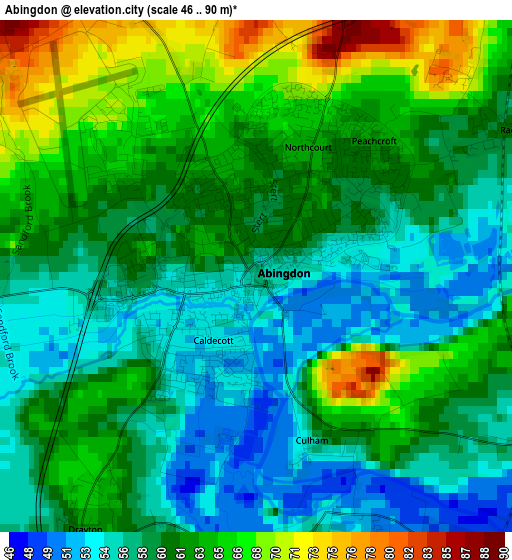
Below is the Elevation map of Abingdon, which displays elevation range with different colors. Scale of the first map is from 46 to 90 m (151 to 295 ft) with average elevation of 60.5 meters (=198 ft) [note 1]
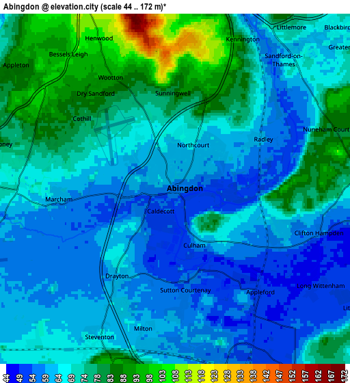
These maps also provides idea of topography and contour of this city, they are displayed at different zoom levels. More info about maps, scale and edge coordinates you can find below images.
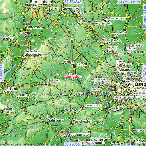
| \ | Map #1 | Map #2 | Topo.Map |
| Scale [m] | 46..90 m | 44..172 m | × |
| Scale [ft] | 151..295 ft | 144..564 ft | × |
| Average | 60.5 m = 198 ft | 68.7 m = 225 ft | × |
| Width | 6.06 km = 3.8 mi | 12.12 km = 7.5 mi | 193.9 km = 120.5 mi |
| Height | 6.06 km = 3.8 mi | 12.12 km = 7.5 mi | 193.9 km = 120.5 mi |
| ↑Max Latitude | 51.698336° | 51.725565° | 52.53484° |
| Latitude at center | 51.67109° | 51.67109° | 51.67109° |
| ↓Min Latitude | 51.643828° | 51.61655° | 50.79055° |
| ← Min Longitude | -1.326725° | -1.370671° | -2.68903° |
| Longitude center | -1.28278° | -1.28278° | -1.28278° |
| →Max Longitude | -1.238835° | -1.194889° | 0.12347° |
Nearby cities:
Cities around Abingdon sort by population:
• Oxford elevation 72 m
9.2 km,  11°
11°
• Didcot 58 m
7.4 km,  157°
157°
• Cowley 75 m
8.6 km,  37°
37°
• Sutton Courtenay 53 m
3.3 km,  172°
172°
• Kingston Bagpuize 86 m
9.6 km,  276°
276°
• Harwell 80 m
8 km,  184°
184°
• Radley 60 m
3.5 km,  58°
58°
• Marcham 61 m
4.2 km,  264°
264°
• Steventon 64 m
5.8 km,  207°
207°
• Garsington 109 m
9.8 km, 59°
• East Hanney 63 m
8.8 km,  242°
242°
• Standlake 68 m
11.6 km,  302°
302°
Multilingual:
 En español:
Abingdon elevación 57 m.
 En France:
Abingdon élévation 57 m.


Sources and notes:
- [note 1] Map square and city borders are not equal. Map elevation data is calculated only from area inside that square.
- [src 1] Elevation data from geonames database provided with same terms of usage.
- [src 2] The elevation map of Abingdon is generated using elevation data from NASA's 3 arcsec (90m) resolution SRTM data.
- [src 3] Base (background) map © OpenStreetMap contributors tiles are generated by Geofabrik and OpenTopoMap.
Copyright & License:
This Abingdon Elevation Map is licensed under CC BY-SA. You may reuse any part from this page, if you give a proper credit by linking to this URL:
 More info on terms of use page.