Cowley elevation
Cowley (England, Oxfordshire), United Kingdom elevation is 75 meters and Cowley elevation in feet is 246 ft above sea level [src 1]. Cowley is a populated place (feature code) with elevation that is 3 meters (10 ft) bigger than average city elevation in United Kingdom.
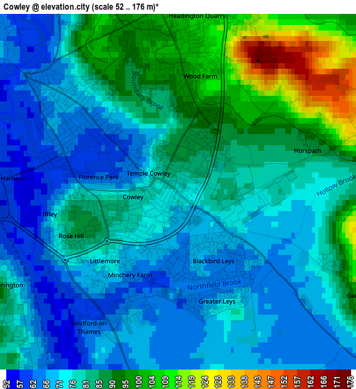
Below is the Elevation map of Cowley, which displays elevation range with different colors. Scale of the first map is from 52 to 176 m (171 to 577 ft) with average elevation of 80.1 meters (=263 ft) [note 1]
These maps also provides idea of topography and contour of this city, they are displayed at different zoom levels. More info about maps, scale and edge coordinates you can find below images.
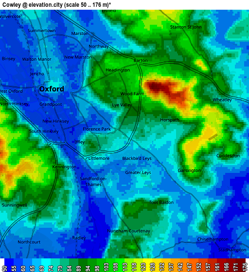
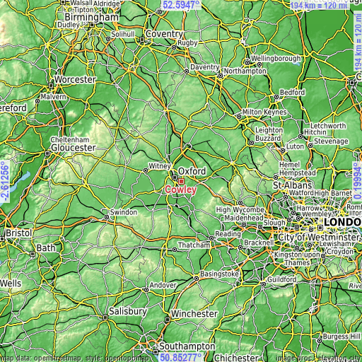
| \ | Map #1 | Map #2 | Topo.Map |
| Scale [m] | 52..176 m | 50..176 m | × |
| Scale [ft] | 171..577 ft | 164..577 ft | × |
| Average | 80.1 m = 263 ft | 78.6 m = 258 ft | × |
| Width | 6.05 km = 3.8 mi | 12.11 km = 7.5 mi | 193.7 km = 120.4 mi |
| Height | 6.05 km = 3.8 mi | 12.1 km = 7.5 mi | 193.7 km = 120.4 mi |
| ↑Max Latitude | 51.759339° | 51.786531° | 52.5947° |
| Latitude at center | 51.73213° | 51.73213° | 51.73213° |
| ↓Min Latitude | 51.704905° | 51.677663° | 50.85277° |
| ← Min Longitude | -1.250255° | -1.294201° | -2.61256° |
| Longitude center | -1.20631° | -1.20631° | -1.20631° |
| →Max Longitude | -1.162365° | -1.118419° | 0.19994° |
Nearby cities:
Cities around Cowley sort by population:
• Oxford elevation 72 m
4.1 km,  303°
303°
• Abingdon 57 m
8.6 km,  217°
217°
• Kidlington 64 m
11.5 km,  330°
330°
• Wheatley 79 m
4.9 km,  69°
69°
• Chalgrove 68 m
11.7 km,  129°
129°
• Yarnton 63 m
10.8 km,  318°
318°
• Sutton Courtenay 53 m
11.2 km,  205°
205°
• Radley 60 m
5.5 km, 205°
• Marcham 61 m
11.8 km,  232°
232°
• Garsington 109 m
3.6 km,  119°
119°
• Wolvercote 60 m
8.3 km,  313°
313°
• Oakley 85 m
12.2 km,  48°
48°
Multilingual:
 En español:
Cowley elevación 75 m.
 En France:
Cowley élévation 75 m.


Sources and notes:
- [note 1] Map square and city borders are not equal. Map elevation data is calculated only from area inside that square.
- [src 1] Elevation data from geonames database provided with same terms of usage.
- [src 2] The elevation map of Cowley is generated using elevation data from NASA's 3 arcsec (90m) resolution SRTM data.
- [src 3] Base (background) map © OpenStreetMap contributors tiles are generated by Geofabrik and OpenTopoMap.
Copyright & License:
This Cowley Elevation Map is licensed under CC BY-SA. You may reuse any part from this page, if you give a proper credit by linking to this URL:
 More info on terms of use page.