Acomb elevation
Acomb (England, Northumberland), United Kingdom elevation is 63 meters and Acomb elevation in feet is 207 ft above sea level [src 1]. Acomb is a seat of a third-order administrative division (feature code) with elevation that is 9 meters (30 ft) smaller than average city elevation in United Kingdom.
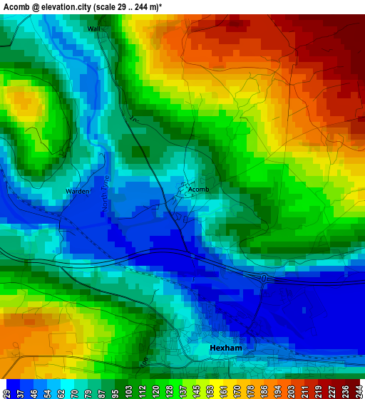
Below is the Elevation map of Acomb, which displays elevation range with different colors. Scale of the first map is from 29 to 244 m (95 to 801 ft) with average elevation of 108.1 meters (=355 ft) [note 1]
These maps also provides idea of topography and contour of this city, they are displayed at different zoom levels. More info about maps, scale and edge coordinates you can find below images.
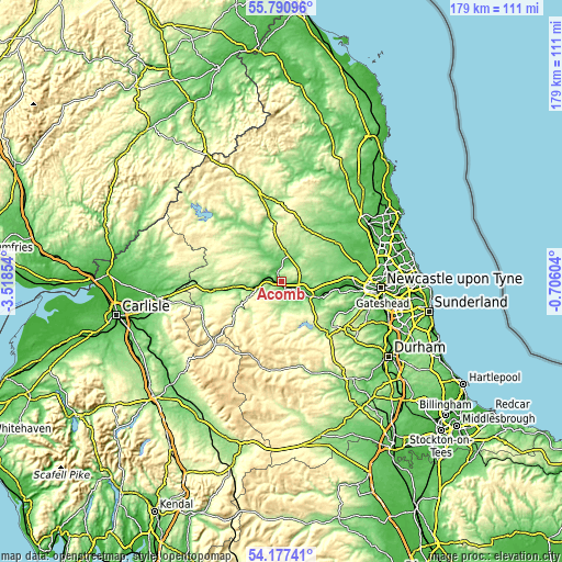
| \ | Map #1 | Topo.Map |
| Scale [m] | 29..244 m | × |
| Scale [ft] | 95..801 ft | × |
| Average | 108.1 m = 355 ft | × |
| Width | 5.61 km = 3.5 mi | 179.4 km = 111.5 mi |
| Height | 5.61 km = 3.5 mi | 179.4 km = 111.5 mi |
| ↑Max Latitude | 55.017493° | 55.79096° |
| Latitude at center | 54.99229° | 54.99229° |
| ↓Min Latitude | 54.967071° | 54.17741° |
| ← Min Longitude | -2.156235° | -3.51854° |
| Longitude center | -2.11229° | -2.11229° |
| →Max Longitude | -2.068345° | -0.70604° |
Nearby cities:
Cities around Acomb sort by population:
• Prudhoe elevation 99 m
17 km,  101°
101°
• Hexham 61 m
2.5 km,  168°
168°
• Corbridge 38 m
6.4 km,  109°
109°
• Stocksfield 74 m
14.5 km, 113°
• Haydon Bridge 65 m
8.8 km,  257°
257°
• Slaley 209 m
10 km,  151°
151°
• Horsley 93 m
16.8 km,  93°
93°
• Bardon Mill 100 m
14.8 km, 262°
• Healey 203 m
12.5 km,  132°
132°
• Birtley 168 m
11.1 km,  335°
335°
• Warden 45 m
1.7 km,  233°
233°
• Wall 49 m
1.6 km,  302°
302°
Multilingual:
 En español:
Acomb elevación 63 m.
 En France:
Acomb élévation 63 m.


Sources and notes:
- [note 1] Map square and city borders are not equal. Map elevation data is calculated only from area inside that square.
- [src 1] Elevation data from geonames database provided with same terms of usage.
- [src 2] The elevation map of Acomb is generated using elevation data from NASA's 3 arcsec (90m) resolution SRTM data.
- [src 3] Base (background) map © OpenStreetMap contributors tiles are generated by Geofabrik and OpenTopoMap.
Copyright & License:
This Acomb Elevation Map is licensed under CC BY-SA. You may reuse any part from this page, if you give a proper credit by linking to this URL:
 More info on terms of use page.