Haydon Bridge elevation
Haydon Bridge (England, Northumberland), United Kingdom elevation is 65 meters and Haydon Bridge elevation in feet is 213 ft above sea level [src 1]. Haydon Bridge is a populated place (feature code) with elevation that is 7 meters (23 ft) smaller than average city elevation in United Kingdom.
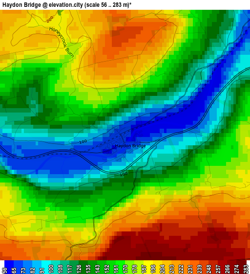
Below is the Elevation map of Haydon Bridge, which displays elevation range with different colors. Scale of the first map is from 56 to 283 m (184 to 928 ft) with average elevation of 162 meters (=531 ft) [note 1]
These maps also provides idea of topography and contour of this city, they are displayed at different zoom levels. More info about maps, scale and edge coordinates you can find below images.
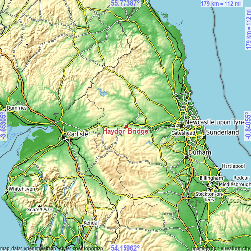
| \ | Map #1 | Topo.Map |
| Scale [m] | 56..283 m | × |
| Scale [ft] | 184..928 ft | × |
| Average | 162 m = 531 ft | × |
| Width | 5.61 km = 3.5 mi | 179.5 km = 111.5 mi |
| Height | 5.61 km = 3.5 mi | 179.5 km = 111.5 mi |
| ↑Max Latitude | 55.000074° | 55.77387° |
| Latitude at center | 54.97486° | 54.97486° |
| ↓Min Latitude | 54.94963° | 54.15962° |
| ← Min Longitude | -2.290745° | -3.65305° |
| Longitude center | -2.2468° | -2.2468° |
| →Max Longitude | -2.202855° | -0.84055° |
Nearby cities:
Cities around Haydon Bridge sort by population:
• Hexham elevation 61 m
9.1 km,  93°
93°
• Haltwhistle 124 m
13.4 km,  268°
268°
• Corbridge 38 m
14.6 km, 90°
• Acomb 63 m
8.8 km,  77°
77°
• Bellingham 123 m
18.9 km,  358°
358°
• Slaley 209 m
15 km,  116°
116°
• Healey 203 m
19 km,  109°
109°
• Greenhead 180 m
17.2 km, 266°
• Birtley 168 m
12.7 km,  18°
18°
• Wall 49 m
7.8 km,  68°
68°
• Warden 45 m
7.3 km, 82°
• Bardon Mill 100 m
6.1 km, 270°
Multilingual:
 En español:
Haydon Bridge elevación 65 m.
 En France:
Haydon Bridge élévation 65 m.
 Auf Deutsch:
Haydon Bridge höhe über dem Meeresspiegel ist 65 m.

Sources and notes:
- [note 1] Map square and city borders are not equal. Map elevation data is calculated only from area inside that square.
- [src 1] Elevation data from geonames database provided with same terms of usage.
- [src 2] The elevation map of Haydon Bridge is generated using elevation data from NASA's 3 arcsec (90m) resolution SRTM data.
- [src 3] Base (background) map © OpenStreetMap contributors tiles are generated by Geofabrik and OpenTopoMap.
Copyright & License:
This Haydon Bridge Elevation Map is licensed under CC BY-SA. You may reuse any part from this page, if you give a proper credit by linking to this URL:
 More info on terms of use page.