Birtley elevation
Birtley (England, Northumberland), United Kingdom elevation is 168 meters and Birtley elevation in feet is 551 ft above sea level [src 1]. Birtley is a seat of a third-order administrative division (feature code) with elevation that is 96 meters (315 ft) bigger than average city elevation in United Kingdom.
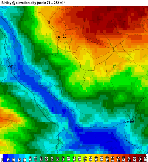
Below is the Elevation map of Birtley, which displays elevation range with different colors. Scale of the first map is from 71 to 252 m (233 to 827 ft) with average elevation of 146.2 meters (=480 ft) [note 1]
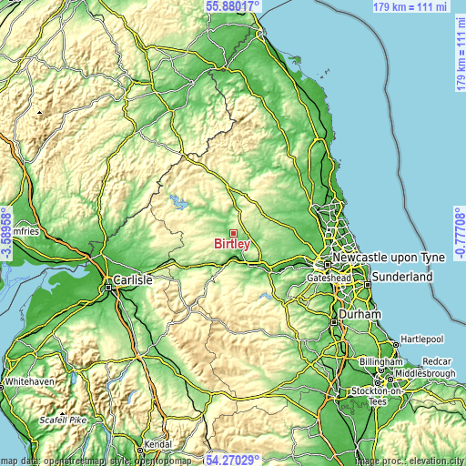
These maps also provides idea of topography and contour of this city, they are displayed at different zoom levels. More info about maps, scale and edge coordinates you can find below images.
| \ | Map #1 | Topo.Map |
| Scale [m] | 71..252 m | × |
| Scale [ft] | 233..827 ft | × |
| Average | 146.2 m = 480 ft | × |
| Width | 5.59 km = 3.5 mi | 179 km = 111.2 mi |
| Height | 5.59 km = 3.5 mi | 179 km = 111.2 mi |
| ↑Max Latitude | 55.108476° | 55.88017° |
| Latitude at center | 55.08333° | 55.08333° |
| ↓Min Latitude | 55.058168° | 54.27029° |
| ← Min Longitude | -2.227275° | -3.58958° |
| Longitude center | -2.18333° | -2.18333° |
| →Max Longitude | -2.139385° | -0.77708° |
Nearby cities:
Cities around Birtley sort by population:
• Hexham elevation 61 m
13.6 km,  158°
158°
• Corbridge 38 m
16.1 km,  139°
139°
• Haydon Bridge 65 m
12.7 km,  198°
198°
• Acomb 63 m
11.1 km, 155°
• Bellingham 123 m
8.2 km,  326°
326°
• Slaley 209 m
21 km,  153°
153°
• Otterburn 160 m
16.7 km,  0°
0°
• Rothley 172 m
20.3 km,  56°
56°
• Bardon Mill 100 m
15.7 km,  220°
220°
• Warden 45 m
11.6 km, 164°
• Corsenside 152 m
11.2 km,  5°
5°
• Wall 49 m
9.8 km, 161°
Multilingual:
 En español:
Birtley elevación 168 m.
 En France:
Birtley élévation 168 m.


Sources and notes:
- [note 1] Map square and city borders are not equal. Map elevation data is calculated only from area inside that square.
- [src 1] Elevation data from geonames database provided with same terms of usage.
- [src 2] The elevation map of Birtley is generated using elevation data from NASA's 3 arcsec (90m) resolution SRTM data.
- [src 3] Base (background) map © OpenStreetMap contributors tiles are generated by Geofabrik and OpenTopoMap.
Copyright & License:
This Birtley Elevation Map is licensed under CC BY-SA. You may reuse any part from this page, if you give a proper credit by linking to this URL:
 More info on terms of use page.