Ammanford elevation
Ammanford (Wales, Carmarthenshire), United Kingdom elevation is 39 meters and Ammanford elevation in feet is 128 ft above sea level [src 1]. Ammanford is a populated place (feature code) with elevation that is 33 meters (108 ft) smaller than average city elevation in United Kingdom.
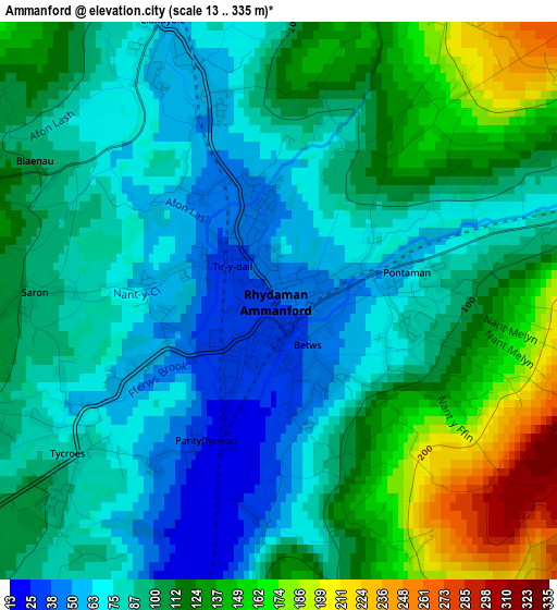
Below is the Elevation map of Ammanford, which displays elevation range with different colors. Scale of the first map is from 13 to 335 m (43 to 1099 ft) with average elevation of 101 meters (=331 ft) [note 1]
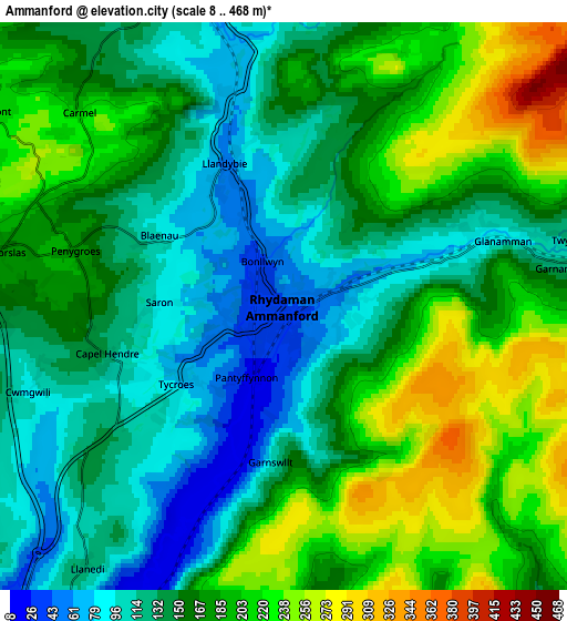
These maps also provides idea of topography and contour of this city, they are displayed at different zoom levels. More info about maps, scale and edge coordinates you can find below images.
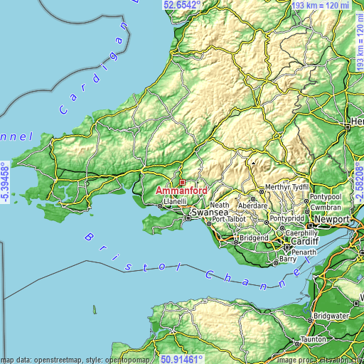
| \ | Map #1 | Map #2 | Topo.Map |
| Scale [m] | 13..335 m | 8..468 m | × |
| Scale [ft] | 43..1099 ft | 26..1535 ft | × |
| Average | 101 m = 331 ft | 162.9 m = 534 ft | × |
| Width | 6.04 km = 3.8 mi | 12.09 km = 7.5 mi | 193.4 km = 120.2 mi |
| Height | 6.04 km = 3.8 mi | 12.09 km = 7.5 mi | 193.4 km = 120.2 mi |
| ↑Max Latitude | 51.819962° | 51.847118° | 52.6542° |
| Latitude at center | 51.79279° | 51.79279° | 51.79279° |
| ↓Min Latitude | 51.765601° | 51.738396° | 50.91461° |
| ← Min Longitude | -4.032275° | -4.076221° | -5.39458° |
| Longitude center | -3.98833° | -3.98833° | -3.98833° |
| →Max Longitude | -3.944385° | -3.900439° | -2.58208° |
Nearby cities:
Cities around Ammanford sort by population:
• Pontarddulais elevation 15 m
9.4 km,  201°
201°
• Brynamman 214 m
8.4 km,  84°
84°
• Cross Hands 139 m
6.8 km,  270°
270°
• Glanamman 107 m
3.9 km, 78°
• Tumble 197 m
8.4 km,  263°
263°
• Llandybie 60 m
3.3 km,  337°
337°
• Tycroes 78 m
2.7 km,  233°
233°
• Llandeilo 59 m
10.2 km,  358°
358°
• Pontyberem 50 m
12.5 km, 262°
• Pontlliw 44 m
11.4 km,  187°
187°
• Grovesend 49 m
12.5 km, 195°
• Llangathen 103 m
10.7 km,  334°
334°
Multilingual:
 En español:
Ammanford elevación 39 m.
 En France:
Ammanford élévation 39 m.
 Auf Deutsch:
Ammanford höhe über dem Meeresspiegel ist 39 m.

Sources and notes:
- [note 1] Map square and city borders are not equal. Map elevation data is calculated only from area inside that square.
- [src 1] Elevation data from geonames database provided with same terms of usage.
- [src 2] The elevation map of Ammanford is generated using elevation data from NASA's 3 arcsec (90m) resolution SRTM data.
- [src 3] Base (background) map © OpenStreetMap contributors tiles are generated by Geofabrik and OpenTopoMap.
Copyright & License:
This Ammanford Elevation Map is licensed under CC BY-SA. You may reuse any part from this page, if you give a proper credit by linking to this URL:
 More info on terms of use page.