Basford elevation
Basford (England, Nottinghamshire), United Kingdom elevation is 35 meters and Basford elevation in feet is 115 ft above sea level [src 1]. Basford is a populated place (feature code) with elevation that is 37 meters (121 ft) smaller than average city elevation in United Kingdom.
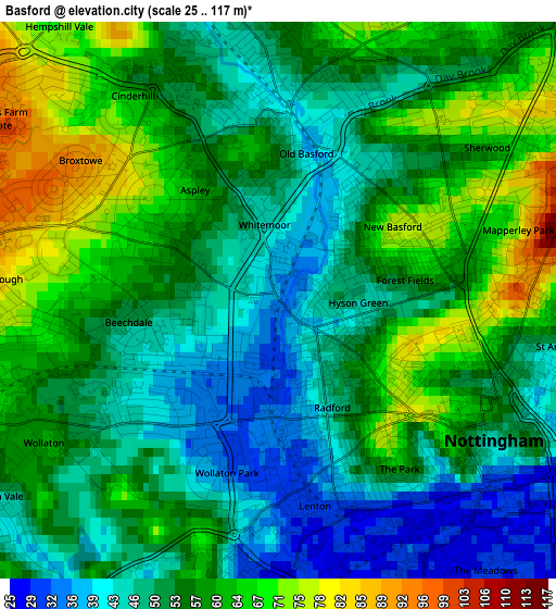
Below is the Elevation map of Basford, which displays elevation range with different colors. Scale of the first map is from 25 to 117 m (82 to 384 ft) with average elevation of 54.7 meters (=179 ft) [note 1]
These maps also provides idea of topography and contour of this city, they are displayed at different zoom levels. More info about maps, scale and edge coordinates you can find below images.
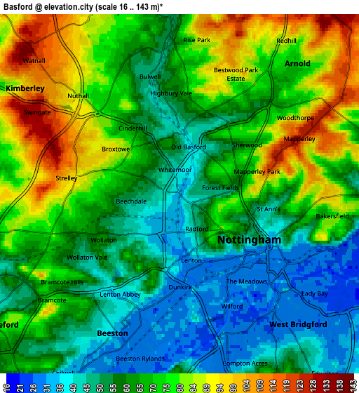
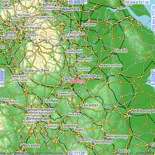
| \ | Map #1 | Map #2 | Topo.Map |
| Scale [m] | 25..117 m | 16..143 m | × |
| Scale [ft] | 82..384 ft | 52..469 ft | × |
| Average | 54.7 m = 179 ft | 65.3 m = 214 ft | × |
| Width | 5.89 km = 3.7 mi | 11.77 km = 7.3 mi | 188.4 km = 117.1 mi |
| Height | 5.89 km = 3.7 mi | 11.77 km = 7.3 mi | 188.3 km = 117 mi |
| ↑Max Latitude | 52.993129° | 53.019572° | 53.80535° |
| Latitude at center | 52.96667° | 52.96667° | 52.96667° |
| ↓Min Latitude | 52.940195° | 52.913703° | 52.11139° |
| ← Min Longitude | -1.227275° | -1.271221° | -2.58958° |
| Longitude center | -1.18333° | -1.18333° | -1.18333° |
| →Max Longitude | -1.139385° | -1.095439° | 0.22292° |
Nearby cities:
Cities around Basford sort by population:
• Nottingham elevation 46 m
2.6 km,  123°
123°
• West Bridgford 28 m
5.6 km,  136°
136°
• Long Eaton 34 m
9.6 km,  217°
217°
• Ilkeston 103 m
8.5 km,  272°
272°
• Arnold 66 m
5 km,  42°
42°
• Hucknall 80 m
7.5 km,  351°
351°
• Eastwood 58 m
8.6 km,  295°
295°
• Kimberley 93 m
5.9 km,  288°
288°
• New Basford 73 m
1.4 km,  57°
57°
• Radcliffe on Trent 30 m
9.9 km,  102°
102°
• Ruddington 41 m
8.5 km,  164°
164°
• Awsworth 88 m
7.2 km, 290°
Multilingual:
 En español:
Basford elevación 35 m.
 En France:
Basford élévation 35 m.


Sources and notes:
- [note 1] Map square and city borders are not equal. Map elevation data is calculated only from area inside that square.
- [src 1] Elevation data from geonames database provided with same terms of usage.
- [src 2] The elevation map of Basford is generated using elevation data from NASA's 3 arcsec (90m) resolution SRTM data.
- [src 3] Base (background) map © OpenStreetMap contributors tiles are generated by Geofabrik and OpenTopoMap.
Copyright & License:
This Basford Elevation Map is licensed under CC BY-SA. You may reuse any part from this page, if you give a proper credit by linking to this URL:
 More info on terms of use page.