Brandon elevation
Brandon (England, County Durham), United Kingdom elevation is 87 meters and Brandon elevation in feet is 285 ft above sea level [src 1]. Brandon is a populated place (feature code) with elevation that is 15 meters (49 ft) bigger than average city elevation in United Kingdom.
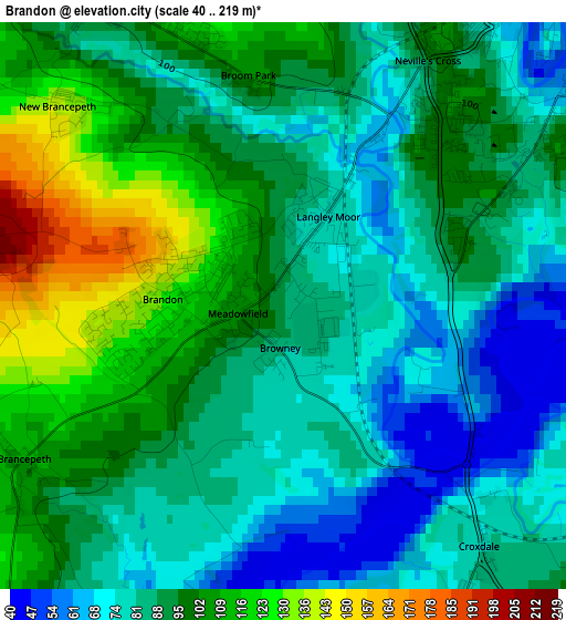
Below is the Elevation map of Brandon, which displays elevation range with different colors. Scale of the first map is from 40 to 219 m (131 to 719 ft) with average elevation of 92 meters (=302 ft) [note 1]
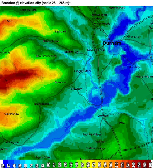
These maps also provides idea of topography and contour of this city, they are displayed at different zoom levels. More info about maps, scale and edge coordinates you can find below images.
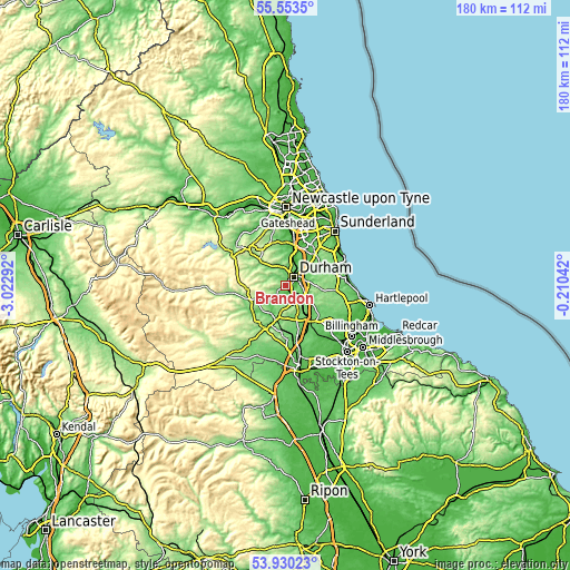
| \ | Map #1 | Map #2 | Topo.Map |
| Scale [m] | 40..219 m | 28..268 m | × |
| Scale [ft] | 131..719 ft | 92..879 ft | × |
| Average | 92 m = 302 ft | 105.1 m = 345 ft | × |
| Width | 5.64 km = 3.5 mi | 11.28 km = 7 mi | 180.5 km = 112.2 mi |
| Height | 5.64 km = 3.5 mi | 11.28 km = 7 mi | 180.5 km = 112.2 mi |
| ↑Max Latitude | 54.775355° | 54.800694° | 55.5535° |
| Latitude at center | 54.75° | 54.75° | 54.75° |
| ↓Min Latitude | 54.724629° | 54.699243° | 53.93023° |
| ← Min Longitude | -1.660615° | -1.704561° | -3.02292° |
| Longitude center | -1.61667° | -1.61667° | -1.61667° |
| →Max Longitude | -1.572725° | -1.528779° | -0.21042° |
Nearby cities:
Cities around Brandon sort by population:
• Durham elevation 52 m
4 km,  41°
41°
• Spennymoor 111 m
5.8 km,  170°
170°
• Ferryhill 122 m
8.6 km,  149°
149°
• Ushaw Moor 116 m
3.7 km,  327°
327°
• Sacriston 154 m
7.5 km,  356°
356°
• Willington 140 m
6.5 km,  235°
235°
• Langley Park 102 m
6.5 km, 328°
• Bowburn 98 m
6 km,  102°
102°
• Coxhoe 108 m
8.3 km,  118°
118°
• Sherburn 88 m
7.7 km,  68°
68°
• West Cornforth 112 m
8.2 km,  129°
129°
• Witton Gilbert 108 m
6.3 km,  348°
348°
Multilingual:
 En español:
Brandon elevación 87 m.
 En France:
Brandon élévation 87 m.


Sources and notes:
- [note 1] Map square and city borders are not equal. Map elevation data is calculated only from area inside that square.
- [src 1] Elevation data from geonames database provided with same terms of usage.
- [src 2] The elevation map of Brandon is generated using elevation data from NASA's 3 arcsec (90m) resolution SRTM data.
- [src 3] Base (background) map © OpenStreetMap contributors tiles are generated by Geofabrik and OpenTopoMap.
Copyright & License:
This Brandon Elevation Map is licensed under CC BY-SA. You may reuse any part from this page, if you give a proper credit by linking to this URL:
 More info on terms of use page.