Chesterfield elevation
Chesterfield (England, Derbyshire), United Kingdom elevation is 89 meters and Chesterfield elevation in feet is 292 ft above sea level [src 1]. Chesterfield is a populated place (feature code) with elevation that is 17 meters (56 ft) bigger than average city elevation in United Kingdom.
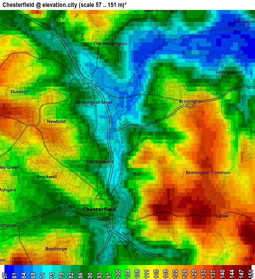
Below is the Elevation map of Chesterfield, which displays elevation range with different colors. Scale of the first map is from 57 to 151 m (187 to 495 ft) with average elevation of 100 meters (=328 ft) [note 1]
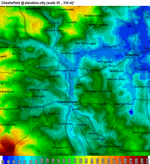
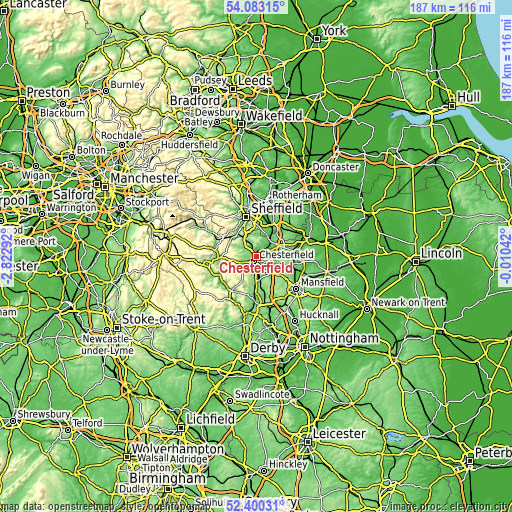
These maps also provides idea of topography and contour of this city, they are displayed at different zoom levels. More info about maps, scale and edge coordinates you can find below images.
| \ | Map #1 | Map #2 | Topo.Map |
| Scale [m] | 57..151 m | 35..310 m | × |
| Scale [ft] | 187..495 ft | 115..1017 ft | × |
| Average | 100 m = 328 ft | 119.4 m = 392 ft | × |
| Width | 5.85 km = 3.6 mi | 11.69 km = 7.3 mi | 187.1 km = 116.3 mi |
| Height | 5.85 km = 3.6 mi | 11.69 km = 7.3 mi | 187.1 km = 116.3 mi |
| ↑Max Latitude | 53.276285° | 53.302555° | 54.08315° |
| Latitude at center | 53.25° | 53.25° | 53.25° |
| ↓Min Latitude | 53.223698° | 53.197381° | 52.40031° |
| ← Min Longitude | -1.460615° | -1.504561° | -2.82292° |
| Longitude center | -1.41667° | -1.41667° | -1.41667° |
| →Max Longitude | -1.372725° | -1.328779° | -0.01042° |
Nearby cities:
Cities around Chesterfield sort by population:
• Staveley elevation 67 m
4.8 km,  67°
67°
• Dronfield 159 m
7 km,  326°
326°
• Bolsover 175 m
8.6 km,  106°
106°
• Beighton 52 m
10.8 km,  30°
30°
• Killamarsh 50 m
10.6 km,  38°
38°
• Clowne 134 m
10.5 km, 74°
• Wingerworth 151 m
5.5 km,  191°
191°
• Pilsley 141 m
11.6 km,  163°
163°
• Barlborough 141 m
9.5 km,  63°
63°
• Walton 132 m
4.2 km,  224°
224°
• Glapwell 176 m
11.2 km,  127°
127°
• Harthill 107 m
12.4 km,  53°
53°
Multilingual:
 En español:
Chesterfield elevación 89 m.
 En France:
Chesterfield élévation 89 m.
 Auf Deutsch:
Chesterfield höhe über dem Meeresspiegel ist 89 m.

Sources and notes:
- [note 1] Map square and city borders are not equal. Map elevation data is calculated only from area inside that square.
- [src 1] Elevation data from geonames database provided with same terms of usage.
- [src 2] The elevation map of Chesterfield is generated using elevation data from NASA's 3 arcsec (90m) resolution SRTM data.
- [src 3] Base (background) map © OpenStreetMap contributors tiles are generated by Geofabrik and OpenTopoMap.
Copyright & License:
This Chesterfield Elevation Map is licensed under CC BY-SA. You may reuse any part from this page, if you give a proper credit by linking to this URL:
 More info on terms of use page.