Pilsley elevation
Pilsley (England, Derbyshire), United Kingdom elevation is 141 meters and Pilsley elevation in feet is 463 ft above sea level [src 1]. Pilsley is a populated place (feature code) with elevation that is 69 meters (226 ft) bigger than average city elevation in United Kingdom.
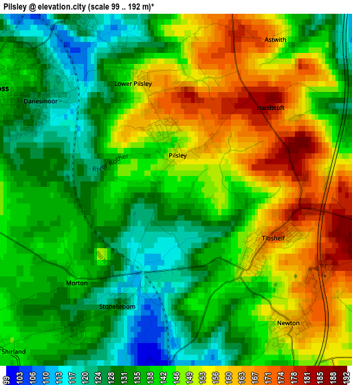
Below is the Elevation map of Pilsley, which displays elevation range with different colors. Scale of the first map is from 99 to 192 m (325 to 630 ft) with average elevation of 142.7 meters (=468 ft) [note 1]
These maps also provides idea of topography and contour of this city, they are displayed at different zoom levels. More info about maps, scale and edge coordinates you can find below images.
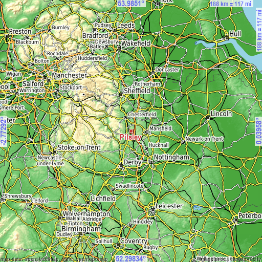
| \ | Map #1 | Topo.Map |
| Scale [m] | 99..192 m | × |
| Scale [ft] | 325..630 ft | × |
| Average | 142.7 m = 468 ft | × |
| Width | 5.86 km = 3.6 mi | 187.6 km = 116.6 mi |
| Height | 5.86 km = 3.6 mi | 187.5 km = 116.5 mi |
| ↑Max Latitude | 53.176347° | 53.9851° |
| Latitude at center | 53.15° | 53.15° |
| ↓Min Latitude | 53.123637° | 52.29834° |
| ← Min Longitude | -1.410615° | -2.77292° |
| Longitude center | -1.36667° | -1.36667° |
| →Max Longitude | -1.322725° | 0.03958° |
Nearby cities:
Cities around Pilsley sort by population:
• Sutton in Ashfield elevation 157 m
7.5 km,  111°
111°
• Kirkby in Ashfield 162 m
9.9 km,  124°
124°
• Alfreton 141 m
5.9 km,  191°
191°
• Pinxton 102 m
7.4 km,  153°
153°
• Bolsover 175 m
10 km,  29°
29°
• Wingerworth 151 m
7.3 km,  322°
322°
• Tibshelf 173 m
1.9 km, 109°
• Shirland 136 m
4.1 km,  218°
218°
• Blackwell 119 m
4.3 km, 149°
• Walton 132 m
10.2 km, 322°
• Glapwell 176 m
7.1 km,  51°
51°
• South Wingfield 122 m
7.8 km, 219°
Multilingual:
 En español:
Pilsley elevación 141 m.
 En France:
Pilsley élévation 141 m.


Sources and notes:
- [note 1] Map square and city borders are not equal. Map elevation data is calculated only from area inside that square.
- [src 1] Elevation data from geonames database provided with same terms of usage.
- [src 2] The elevation map of Pilsley is generated using elevation data from NASA's 3 arcsec (90m) resolution SRTM data.
- [src 3] Base (background) map © OpenStreetMap contributors tiles are generated by Geofabrik and OpenTopoMap.
Copyright & License:
This Pilsley Elevation Map is licensed under CC BY-SA. You may reuse any part from this page, if you give a proper credit by linking to this URL:
 More info on terms of use page.