Pinxton elevation
Pinxton (England, Derbyshire), United Kingdom elevation is 102 meters and Pinxton elevation in feet is 335 ft above sea level [src 1]. Pinxton is a populated place (feature code) with elevation that is 30 meters (98 ft) bigger than average city elevation in United Kingdom.
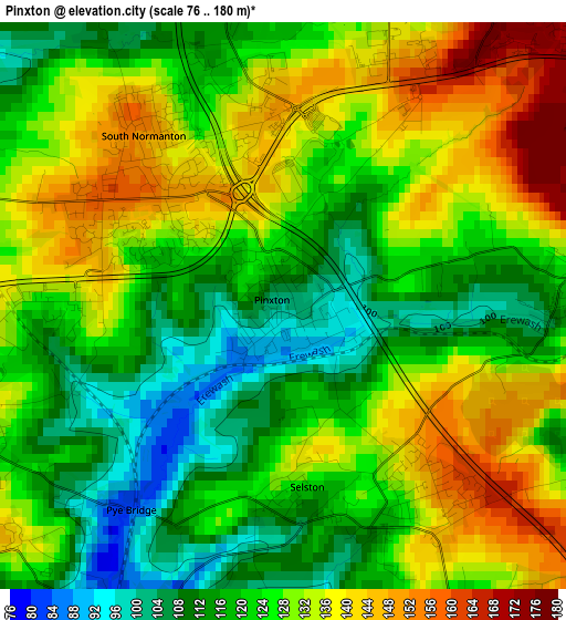
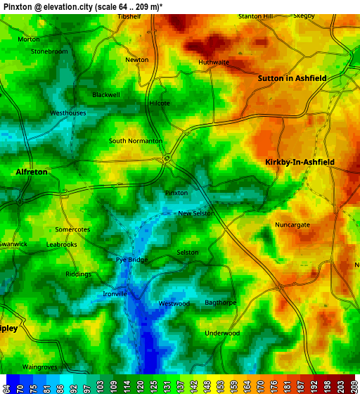
Below is the Elevation map of Pinxton, which displays elevation range with different colors. Scale of the first map is from 76 to 180 m (249 to 591 ft) with average elevation of 125.7 meters (=412 ft) [note 1]
These maps also provides idea of topography and contour of this city, they are displayed at different zoom levels. More info about maps, scale and edge coordinates you can find below images.
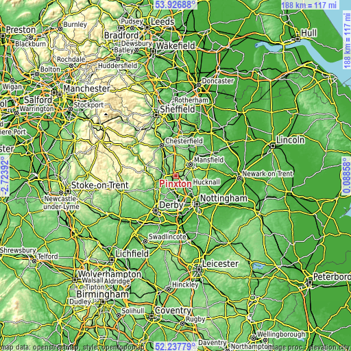
| \ | Map #1 | Map #2 | Topo.Map |
| Scale [m] | 76..180 m | 64..209 m | × |
| Scale [ft] | 249..591 ft | 210..686 ft | × |
| Average | 125.7 m = 412 ft | 134.2 m = 440 ft | × |
| Width | 5.87 km = 3.6 mi | 11.74 km = 7.3 mi | 187.8 km = 116.7 mi |
| Height | 5.87 km = 3.6 mi | 11.74 km = 7.3 mi | 187.8 km = 116.7 mi |
| ↑Max Latitude | 53.117003° | 53.14337° | 53.92688° |
| Latitude at center | 53.09062° | 53.09062° | 53.09062° |
| ↓Min Latitude | 53.06422° | 53.037805° | 52.23779° |
| ← Min Longitude | -1.361615° | -1.405561° | -2.72392° |
| Longitude center | -1.31767° | -1.31767° | -1.31767° |
| →Max Longitude | -1.273725° | -1.229779° | 0.08858° |
Nearby cities:
Cities around Pinxton sort by population:
• Mansfield elevation 122 m
9.2 km,  58°
58°
• Sutton in Ashfield 157 m
5.4 km,  44°
44°
• Kirkby in Ashfield 162 m
5 km,  78°
78°
• Heanor 127 m
8.9 km,  195°
195°
• Alfreton 141 m
4.5 km,  280°
280°
• Ripley 126 m
8.4 km,  220°
220°
• Tibshelf 173 m
6.2 km,  345°
345°
• Shirland 136 m
6.7 km,  300°
300°
• Pilsley 141 m
7.4 km,  333°
333°
• Blackwell 119 m
3.1 km,  340°
340°
• Heage 118 m
9.7 km,  242°
242°
• South Wingfield 122 m
8.2 km,  274°
274°
Multilingual:
 En español:
Pinxton elevación 102 m.
 En France:
Pinxton élévation 102 m.


Sources and notes:
- [note 1] Map square and city borders are not equal. Map elevation data is calculated only from area inside that square.
- [src 1] Elevation data from geonames database provided with same terms of usage.
- [src 2] The elevation map of Pinxton is generated using elevation data from NASA's 3 arcsec (90m) resolution SRTM data.
- [src 3] Base (background) map © OpenStreetMap contributors tiles are generated by Geofabrik and OpenTopoMap.
Copyright & License:
This Pinxton Elevation Map is licensed under CC BY-SA. You may reuse any part from this page, if you give a proper credit by linking to this URL:
 More info on terms of use page.