Mansfield elevation
Mansfield (England, Nottinghamshire), United Kingdom elevation is 122 meters and Mansfield elevation in feet is 400 ft above sea level [src 1]. Mansfield is a populated place (feature code) with elevation that is 50 meters (164 ft) bigger than average city elevation in United Kingdom.
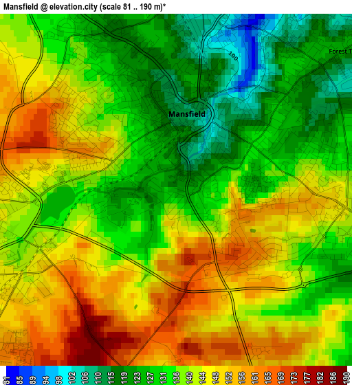
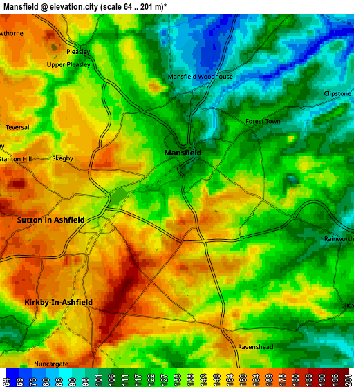
Below is the Elevation map of Mansfield, which displays elevation range with different colors. Scale of the first map is from 81 to 190 m (266 to 623 ft) with average elevation of 138.8 meters (=455 ft) [note 1]
These maps also provides idea of topography and contour of this city, they are displayed at different zoom levels. More info about maps, scale and edge coordinates you can find below images.
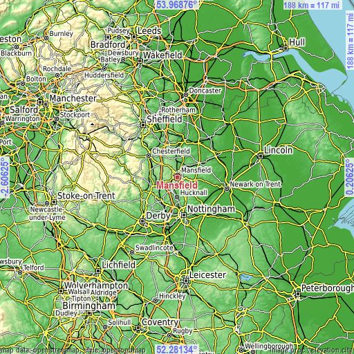
| \ | Map #1 | Map #2 | Topo.Map |
| Scale [m] | 81..190 m | 64..201 m | × |
| Scale [ft] | 266..623 ft | 210..659 ft | × |
| Average | 138.8 m = 455 ft | 133.1 m = 437 ft | × |
| Width | 5.86 km = 3.6 mi | 11.73 km = 7.3 mi | 187.6 km = 116.6 mi |
| Height | 5.86 km = 3.6 mi | 11.73 km = 7.3 mi | 187.6 km = 116.6 mi |
| ↑Max Latitude | 53.159687° | 53.186028° | 53.96876° |
| Latitude at center | 53.13333° | 53.13333° | 53.13333° |
| ↓Min Latitude | 53.106957° | 53.080567° | 52.28134° |
| ← Min Longitude | -1.243945° | -1.287891° | -2.60625° |
| Longitude center | -1.2° | -1.2° | -1.2° |
| →Max Longitude | -1.156055° | -1.112109° | 0.20625° |
Nearby cities:
Cities around Mansfield sort by population:
• Sutton in Ashfield elevation 157 m
4.2 km,  257°
257°
• Kirkby in Ashfield 162 m
4.7 km,  218°
218°
• Mansfield Woodhouse 88 m
3.5 km,  6°
6°
• Pinxton 102 m
9.2 km,  238°
238°
• Shirebrook 87 m
7.8 km,  353°
353°
• Market Warsop 61 m
8.6 km,  21°
21°
• Rainworth 99 m
5.7 km,  106°
106°
• Ravenshead 137 m
5.8 km,  153°
153°
• Blidworth 111 m
6.8 km,  124°
124°
• King's Clipstone 76 m
8.2 km,  53°
53°
• Blackwell 119 m
9.1 km, 258°
• Glapwell 176 m
8.3 km,  318°
318°
Multilingual:
 En español:
Mansfield elevación 122 m.
 En France:
Mansfield élévation 122 m.
 Auf Deutsch:
Mansfield höhe über dem Meeresspiegel ist 122 m.

Sources and notes:
- [note 1] Map square and city borders are not equal. Map elevation data is calculated only from area inside that square.
- [src 1] Elevation data from geonames database provided with same terms of usage.
- [src 2] The elevation map of Mansfield is generated using elevation data from NASA's 3 arcsec (90m) resolution SRTM data.
- [src 3] Base (background) map © OpenStreetMap contributors tiles are generated by Geofabrik and OpenTopoMap.
Copyright & License:
This Mansfield Elevation Map is licensed under CC BY-SA. You may reuse any part from this page, if you give a proper credit by linking to this URL:
 More info on terms of use page.