Congleton elevation
Congleton (England, Cheshire East), United Kingdom elevation is 90 meters and Congleton elevation in feet is 295 ft above sea level [src 1]. Congleton is a populated place (feature code) with elevation that is 18 meters (59 ft) bigger than average city elevation in United Kingdom.
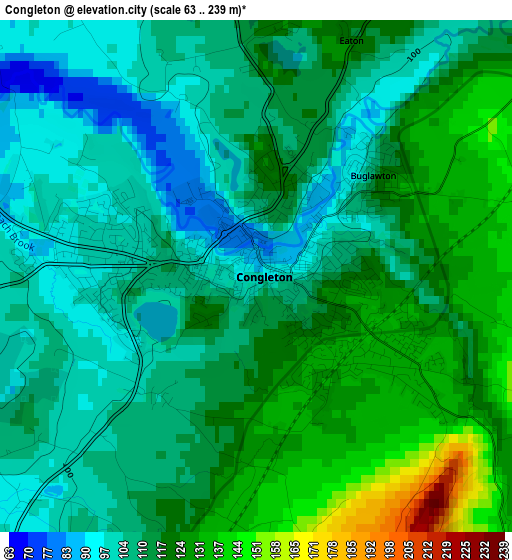
Below is the Elevation map of Congleton, which displays elevation range with different colors. Scale of the first map is from 63 to 239 m (207 to 784 ft) with average elevation of 114 meters (=374 ft) [note 1]
These maps also provides idea of topography and contour of this city, they are displayed at different zoom levels. More info about maps, scale and edge coordinates you can find below images.
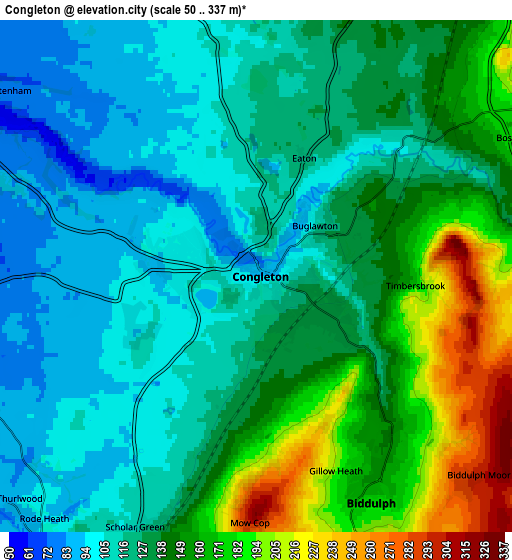
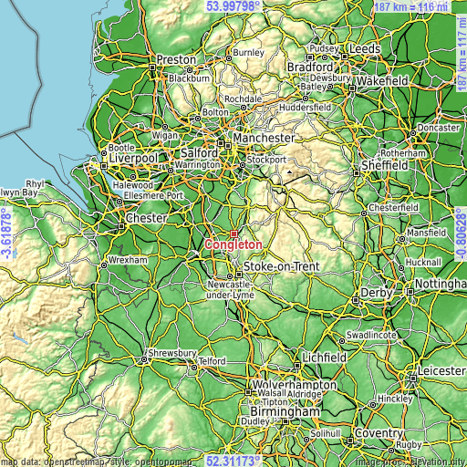
| \ | Map #1 | Map #2 | Topo.Map |
| Scale [m] | 63..239 m | 50..337 m | × |
| Scale [ft] | 207..784 ft | 164..1106 ft | × |
| Average | 114 m = 374 ft | 136.1 m = 447 ft | × |
| Width | 5.86 km = 3.6 mi | 11.72 km = 7.3 mi | 187.5 km = 116.5 mi |
| Height | 5.86 km = 3.6 mi | 11.72 km = 7.3 mi | 187.5 km = 116.5 mi |
| ↑Max Latitude | 53.189479° | 53.215801° | 53.99798° |
| Latitude at center | 53.16314° | 53.16314° | 53.16314° |
| ↓Min Latitude | 53.136785° | 53.110414° | 52.31173° |
| ← Min Longitude | -2.256475° | -2.300421° | -3.61878° |
| Longitude center | -2.21253° | -2.21253° | -2.21253° |
| →Max Longitude | -2.168585° | -2.124639° | -0.80628° |
Nearby cities:
Cities around Congleton sort by population:
• Macclesfield elevation 156 m
12.2 km,  28°
28°
• Kidsgrove 148 m
8.6 km,  191°
191°
• Sandbach 69 m
10.2 km,  258°
258°
• Biddulph 173 m
5.7 km,  154°
154°
• Alsager 95 m
9.7 km,  220°
220°
• Tunstall 152 m
11.7 km,  179°
179°
• Holmes Chapel 62 m
10.6 km,  293°
293°
• Rode Heath 92 m
7.6 km, 224°
• Goostrey 68 m
11 km,  310°
310°
• Chelford 78 m
12.9 km,  338°
338°
• Siddington 99 m
7.9 km,  349°
349°
• Eaton 118 m
2.4 km,  20°
20°
Multilingual:
 En español:
Congleton elevación 90 m.
 En France:
Congleton élévation 90 m.
 Auf Deutsch:
Congleton höhe über dem Meeresspiegel ist 90 m.

Sources and notes:
- [note 1] Map square and city borders are not equal. Map elevation data is calculated only from area inside that square.
- [src 1] Elevation data from geonames database provided with same terms of usage.
- [src 2] The elevation map of Congleton is generated using elevation data from NASA's 3 arcsec (90m) resolution SRTM data.
- [src 3] Base (background) map © OpenStreetMap contributors tiles are generated by Geofabrik and OpenTopoMap.
Copyright & License:
This Congleton Elevation Map is licensed under CC BY-SA. You may reuse any part from this page, if you give a proper credit by linking to this URL:
 More info on terms of use page.