Dodworth elevation
Dodworth (England, Barnsley), United Kingdom elevation is 141 meters and Dodworth elevation in feet is 463 ft above sea level [src 1]. Dodworth is a populated place (feature code) with elevation that is 69 meters (226 ft) bigger than average city elevation in United Kingdom.
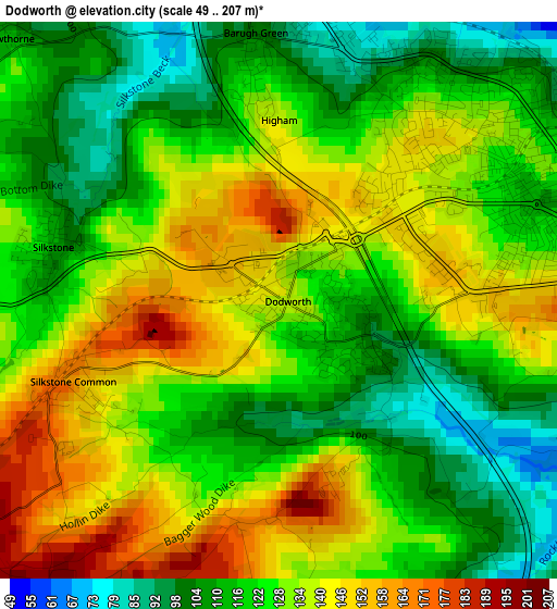
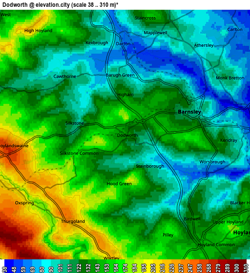
Below is the Elevation map of Dodworth, which displays elevation range with different colors. Scale of the first map is from 49 to 207 m (161 to 679 ft) with average elevation of 127 meters (=417 ft) [note 1]
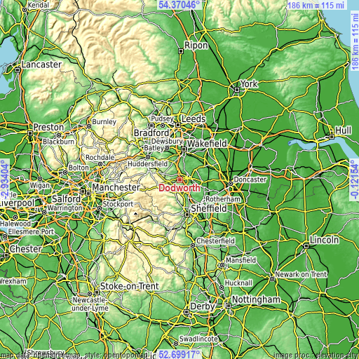
These maps also provides idea of topography and contour of this city, they are displayed at different zoom levels. More info about maps, scale and edge coordinates you can find below images.
| \ | Map #1 | Map #2 | Topo.Map |
| Scale [m] | 49..207 m | 38..310 m | × |
| Scale [ft] | 161..679 ft | 125..1017 ft | × |
| Average | 127 m = 417 ft | 133.6 m = 438 ft | × |
| Width | 5.81 km = 3.6 mi | 11.61 km = 7.2 mi | 185.8 km = 115.5 mi |
| Height | 5.81 km = 3.6 mi | 11.61 km = 7.2 mi | 185.8 km = 115.5 mi |
| ↑Max Latitude | 53.569165° | 53.595254° | 54.37046° |
| Latitude at center | 53.54306° | 53.54306° | 53.54306° |
| ↓Min Latitude | 53.516939° | 53.490802° | 52.69917° |
| ← Min Longitude | -1.571735° | -1.615681° | -2.93404° |
| Longitude center | -1.52779° | -1.52779° | -1.52779° |
| →Max Longitude | -1.483845° | -1.439899° | -0.12154° |
Nearby cities:
Cities around Dodworth sort by population:
• Barnsley elevation 112 m
3 km,  75°
75°
• Hoyland Nether 162 m
7 km,  132°
132°
• Darton 69 m
4.9 km,  0°
0°
• Stocksbridge 164 m
8 km,  212°
212°
• Cudworth 68 m
8 km,  66°
66°
• Penistone 231 m
7 km,  254°
254°
• Birdwell 126 m
4.6 km,  135°
135°
• Silkstone 114 m
2.4 km,  283°
283°
• Cawthorne 104 m
4 km,  311°
311°
• Woolley 117 m
7.9 km,  6°
6°
• Wortley 220 m
6.7 km,  183°
183°
• Stainborough 157 m
2 km,  160°
160°
Multilingual:
 En español:
Dodworth elevación 141 m.
 En France:
Dodworth élévation 141 m.
 Auf Deutsch:
Dodworth höhe über dem Meeresspiegel ist 141 m.

Sources and notes:
- [note 1] Map square and city borders are not equal. Map elevation data is calculated only from area inside that square.
- [src 1] Elevation data from geonames database provided with same terms of usage.
- [src 2] The elevation map of Dodworth is generated using elevation data from NASA's 3 arcsec (90m) resolution SRTM data.
- [src 3] Base (background) map © OpenStreetMap contributors tiles are generated by Geofabrik and OpenTopoMap.
Copyright & License:
This Dodworth Elevation Map is licensed under CC BY-SA. You may reuse any part from this page, if you give a proper credit by linking to this URL:
 More info on terms of use page.