Dunlop elevation
Dunlop (Scotland, East Ayrshire), United Kingdom elevation is 133 meters and Dunlop elevation in feet is 436 ft above sea level [src 1]. Dunlop is a populated place (feature code) with elevation that is 61 meters (200 ft) bigger than average city elevation in United Kingdom.
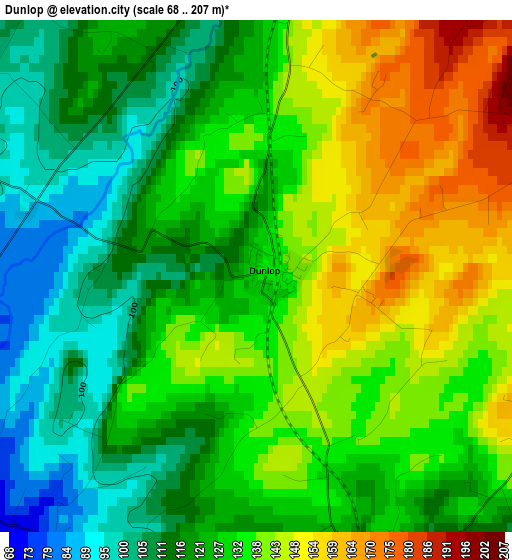
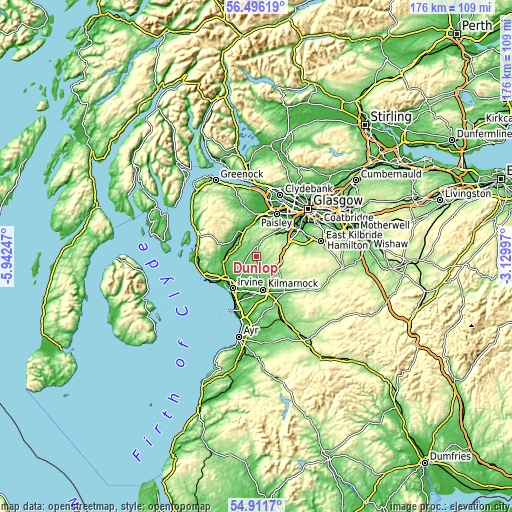
Below is the Elevation map of Dunlop, which displays elevation range with different colors. Scale of the first map is from 68 to 207 m (223 to 679 ft) with average elevation of 129.4 meters (=425 ft) [note 1]
These maps also provides idea of topography and contour of this city, they are displayed at different zoom levels. More info about maps, scale and edge coordinates you can find below images.
| \ | Map #1 | Topo.Map |
| Scale [m] | 68..207 m | × |
| Scale [ft] | 223..679 ft | × |
| Average | 129.4 m = 425 ft | × |
| Width | 5.51 km = 3.4 mi | 176.2 km = 109.5 mi |
| Height | 5.51 km = 3.4 mi | 176.2 km = 109.5 mi |
| ↑Max Latitude | 55.736729° | 56.49619° |
| Latitude at center | 55.71198° | 55.71198° |
| ↓Min Latitude | 55.687215° | 54.9117° |
| ← Min Longitude | -4.580165° | -5.94247° |
| Longitude center | -4.53622° | -4.53622° |
| →Max Longitude | -4.492275° | -3.12997° |
Nearby cities:
Cities around Dunlop sort by population:
• Kilmarnock elevation 39 m
11.4 km,  167°
167°
• Kilbirnie 56 m
10.4 km,  294°
294°
• Stewarton 97 m
3.8 km,  159°
159°
• Beith 93 m
7.5 km,  303°
303°
• Dalry 44 m
11.6 km,  268°
268°
• Neilston 136 m
10.7 km,  39°
39°
• Lochwinnoch 36 m
11 km,  327°
327°
• Crosshouse 33 m
11.1 km,  184°
184°
• Kilmaurs 61 m
8.2 km, 176°
• Howwood 38 m
11 km,  353°
353°
• Springside 27 m
11.3 km,  197°
197°
• Fenwick 137 m
8.3 km,  135°
135°
Multilingual:
 En español:
Dunlop elevación 133 m.
 En France:
Dunlop élévation 133 m.


Sources and notes:
- [note 1] Map square and city borders are not equal. Map elevation data is calculated only from area inside that square.
- [src 1] Elevation data from geonames database provided with same terms of usage.
- [src 2] The elevation map of Dunlop is generated using elevation data from NASA's 3 arcsec (90m) resolution SRTM data.
- [src 3] Base (background) map © OpenStreetMap contributors tiles are generated by Geofabrik and OpenTopoMap.
Copyright & License:
This Dunlop Elevation Map is licensed under CC BY-SA. You may reuse any part from this page, if you give a proper credit by linking to this URL:
 More info on terms of use page.