Stewarton elevation
Stewarton (Scotland, East Ayrshire), United Kingdom elevation is 97 meters and Stewarton elevation in feet is 318 ft above sea level [src 1]. Stewarton is a populated place (feature code) with elevation that is 25 meters (82 ft) bigger than average city elevation in United Kingdom.
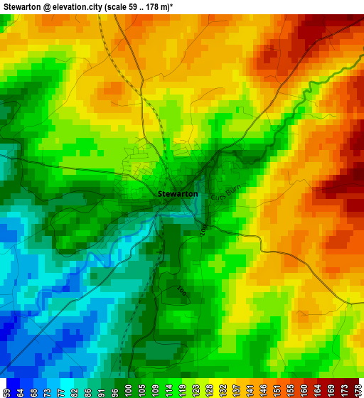
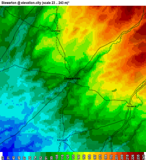
Below is the Elevation map of Stewarton, which displays elevation range with different colors. Scale of the first map is from 59 to 178 m (194 to 584 ft) with average elevation of 118.3 meters (=388 ft) [note 1]
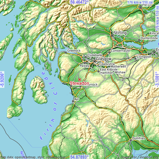
These maps also provides idea of topography and contour of this city, they are displayed at different zoom levels. More info about maps, scale and edge coordinates you can find below images.
| \ | Map #1 | Map #2 | Topo.Map |
| Scale [m] | 59..178 m | 23..243 m | × |
| Scale [ft] | 194..584 ft | 75..797 ft | × |
| Average | 118.3 m = 388 ft | 117.4 m = 385 ft | × |
| Width | 5.51 km = 3.4 mi | 11.02 km = 6.8 mi | 176.3 km = 109.5 mi |
| Height | 5.51 km = 3.4 mi | 11.02 km = 6.8 mi | 176.3 km = 109.5 mi |
| ↑Max Latitude | 55.704629° | 55.729383° | 56.46472° |
| Latitude at center | 55.67986° | 55.67986° | 55.67986° |
| ↓Min Latitude | 55.655075° | 55.630274° | 54.87893° |
| ← Min Longitude | -4.558295° | -4.602241° | -5.9206° |
| Longitude center | -4.51435° | -4.51435° | -4.51435° |
| →Max Longitude | -4.470405° | -4.426459° | -3.1081° |
Nearby cities:
Cities around Stewarton sort by population:
• Kilmarnock elevation 39 m
7.7 km,  171°
171°
• Irvine 14 m
11.1 km,  232°
232°
• Kilwinning 22 m
12.4 km,  256°
256°
• Beith 93 m
10.9 km,  315°
315°
• Galston 52 m
12.1 km,  136°
136°
• Dreghorn 18 m
10.5 km,  220°
220°
• Crosshouse 33 m
7.8 km,  197°
197°
• Kilmaurs 61 m
4.7 km,  189°
189°
• Dundonald 38 m
12.3 km, 204°
• Springside 27 m
8.6 km,  213°
213°
• Dunlop 133 m
3.8 km,  339°
339°
• Fenwick 137 m
5.1 km,  118°
118°
Multilingual:
 En español:
Stewarton elevación 97 m.
 En France:
Stewarton élévation 97 m.
 Auf Deutsch:
Stewarton höhe über dem Meeresspiegel ist 97 m.

Sources and notes:
- [note 1] Map square and city borders are not equal. Map elevation data is calculated only from area inside that square.
- [src 1] Elevation data from geonames database provided with same terms of usage.
- [src 2] The elevation map of Stewarton is generated using elevation data from NASA's 3 arcsec (90m) resolution SRTM data.
- [src 3] Base (background) map © OpenStreetMap contributors tiles are generated by Geofabrik and OpenTopoMap.
Copyright & License:
This Stewarton Elevation Map is licensed under CC BY-SA. You may reuse any part from this page, if you give a proper credit by linking to this URL:
 More info on terms of use page.