Dalry elevation
Dalry (Scotland, North Ayrshire), United Kingdom elevation is 44 meters and Dalry elevation in feet is 144 ft above sea level [src 1]. Dalry is a populated place (feature code) with elevation that is 28 meters (92 ft) smaller than average city elevation in United Kingdom.
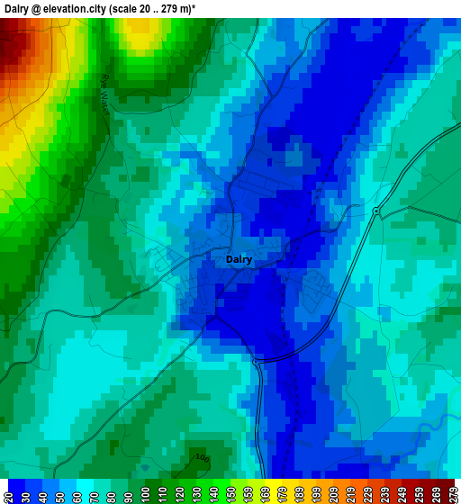
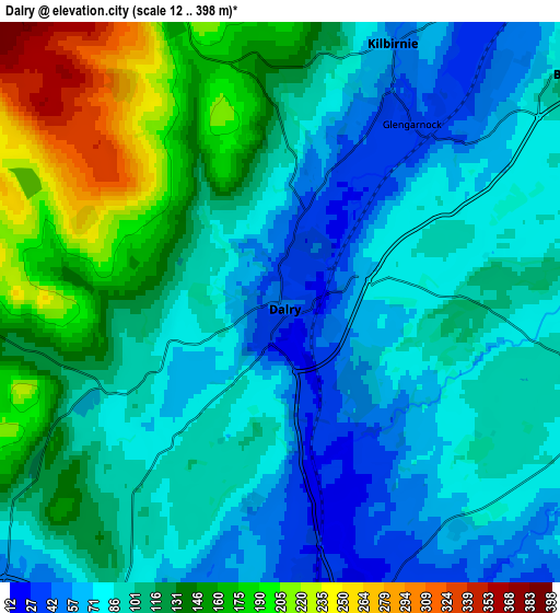
Below is the Elevation map of Dalry, which displays elevation range with different colors. Scale of the first map is from 20 to 279 m (66 to 915 ft) with average elevation of 73.1 meters (=240 ft) [note 1]
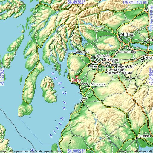
These maps also provides idea of topography and contour of this city, they are displayed at different zoom levels. More info about maps, scale and edge coordinates you can find below images.
| \ | Map #1 | Map #2 | Topo.Map |
| Scale [m] | 20..279 m | 12..398 m | × |
| Scale [ft] | 66..915 ft | 39..1306 ft | × |
| Average | 73.1 m = 240 ft | 108.8 m = 357 ft | × |
| Width | 5.51 km = 3.4 mi | 11.01 km = 6.8 mi | 176.2 km = 109.5 mi |
| Height | 5.51 km = 3.4 mi | 11.01 km = 6.8 mi | 176.2 km = 109.5 mi |
| ↑Max Latitude | 55.73431° | 55.759045° | 56.49382° |
| Latitude at center | 55.70956° | 55.70956° | 55.70956° |
| ↓Min Latitude | 55.684794° | 55.660012° | 54.90923° |
| ← Min Longitude | -4.765615° | -4.809561° | -6.12792° |
| Longitude center | -4.72167° | -4.72167° | -4.72167° |
| →Max Longitude | -4.677725° | -4.633779° | -3.31542° |
Nearby cities:
Cities around Dalry sort by population:
• Irvine elevation 14 m
10.9 km,  157°
157°
• Kilwinning 22 m
6.3 km,  171°
171°
• Saltcoats 10 m
9.1 km,  206°
206°
• Ardrossan 21 m
8.5 km,  218°
218°
• Stevenston 9 m
8 km,  194°
194°
• Kilbirnie 56 m
5.1 km,  24°
24°
• Beith 93 m
6.9 km,  50°
50°
• West Kilbride 51 m
8.8 km,  255°
255°
• Dreghorn 18 m
12.9 km,  151°
151°
• Lochwinnoch 36 m
11.1 km,  30°
30°
• Fairlie 6 m
9.9 km,  301°
301°
• Dunlop 133 m
11.6 km,  88°
88°
Multilingual:
 En español:
Dalry elevación 44 m.
 En France:
Dalry élévation 44 m.


Sources and notes:
- [note 1] Map square and city borders are not equal. Map elevation data is calculated only from area inside that square.
- [src 1] Elevation data from geonames database provided with same terms of usage.
- [src 2] The elevation map of Dalry is generated using elevation data from NASA's 3 arcsec (90m) resolution SRTM data.
- [src 3] Base (background) map © OpenStreetMap contributors tiles are generated by Geofabrik and OpenTopoMap.
Copyright & License:
This Dalry Elevation Map is licensed under CC BY-SA. You may reuse any part from this page, if you give a proper credit by linking to this URL:
 More info on terms of use page.