Eccleshall elevation
Eccleshall (England, Staffordshire), United Kingdom elevation is 98 meters and Eccleshall elevation in feet is 322 ft above sea level [src 1]. Eccleshall is a populated place (feature code) with elevation that is 26 meters (85 ft) bigger than average city elevation in United Kingdom.
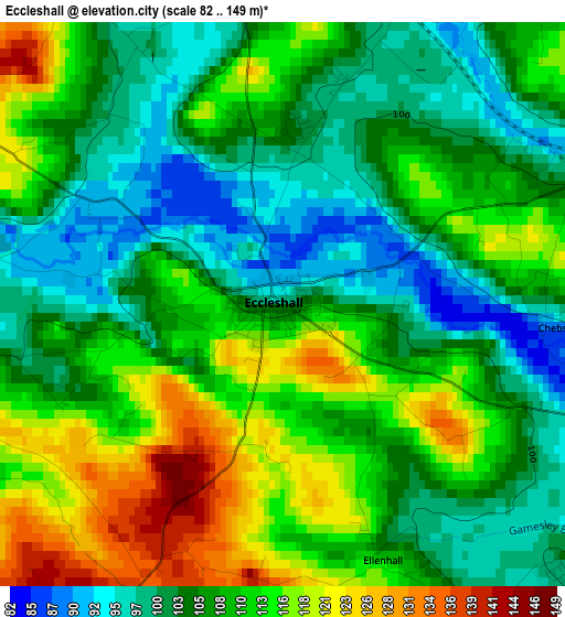
Below is the Elevation map of Eccleshall, which displays elevation range with different colors. Scale of the first map is from 82 to 149 m (269 to 489 ft) with average elevation of 108.1 meters (=355 ft) [note 1]
These maps also provides idea of topography and contour of this city, they are displayed at different zoom levels. More info about maps, scale and edge coordinates you can find below images.
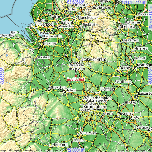
| \ | Map #1 | Topo.Map |
| Scale [m] | 82..149 m | × |
| Scale [ft] | 269..489 ft | × |
| Average | 108.1 m = 355 ft | × |
| Width | 5.9 km = 3.7 mi | 188.8 km = 117.3 mi |
| Height | 5.9 km = 3.7 mi | 188.8 km = 117.3 mi |
| ↑Max Latitude | 52.884416° | 53.69869° |
| Latitude at center | 52.85789° | 52.85789° |
| ↓Min Latitude | 52.831348° | 52.00048° |
| ← Min Longitude | -2.293655° | -3.65596° |
| Longitude center | -2.24971° | -2.24971° |
| →Max Longitude | -2.205765° | -0.84346° |
Nearby cities:
Cities around Eccleshall sort by population:
• Newcastle under Lyme elevation 160 m
15.8 km,  3°
3°
• Stafford 77 m
10.7 km,  123°
123°
• Stone 94 m
8.3 km,  50°
50°
• Longton 150 m
16 km,  29°
29°
• Newport 75 m
13.3 km,  220°
220°
• Gnosall 102 m
8 km,  182°
182°
• Standon 129 m
6.9 km,  340°
340°
• Woodcote 112 m
14.9 km,  202°
202°
• Barlaston 106 m
10.8 km, 29°
• Wheaton Aston 112 m
16.4 km,  173°
173°
• Edgmond 77 m
14.2 km,  229°
229°
• Chetwynd 87 m
13.1 km, 230°
Multilingual:
 En español:
Eccleshall elevación 98 m.
 En France:
Eccleshall élévation 98 m.
 Auf Deutsch:
Eccleshall höhe über dem Meeresspiegel ist 98 m.

Sources and notes:
- [note 1] Map square and city borders are not equal. Map elevation data is calculated only from area inside that square.
- [src 1] Elevation data from geonames database provided with same terms of usage.
- [src 2] The elevation map of Eccleshall is generated using elevation data from NASA's 3 arcsec (90m) resolution SRTM data.
- [src 3] Base (background) map © OpenStreetMap contributors tiles are generated by Geofabrik and OpenTopoMap.
Copyright & License:
This Eccleshall Elevation Map is licensed under CC BY-SA. You may reuse any part from this page, if you give a proper credit by linking to this URL:
 More info on terms of use page.