Gnosall elevation
Gnosall (England, Staffordshire), United Kingdom elevation is 102 meters and Gnosall elevation in feet is 335 ft above sea level [src 1]. Gnosall is a populated place (feature code) with elevation that is 30 meters (98 ft) bigger than average city elevation in United Kingdom.
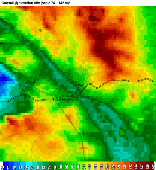
Below is the Elevation map of Gnosall, which displays elevation range with different colors. Scale of the first map is from 74 to 142 m (243 to 466 ft) with average elevation of 110.2 meters (=362 ft) [note 1]
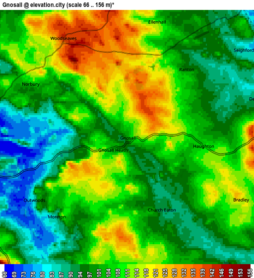
These maps also provides idea of topography and contour of this city, they are displayed at different zoom levels. More info about maps, scale and edge coordinates you can find below images.
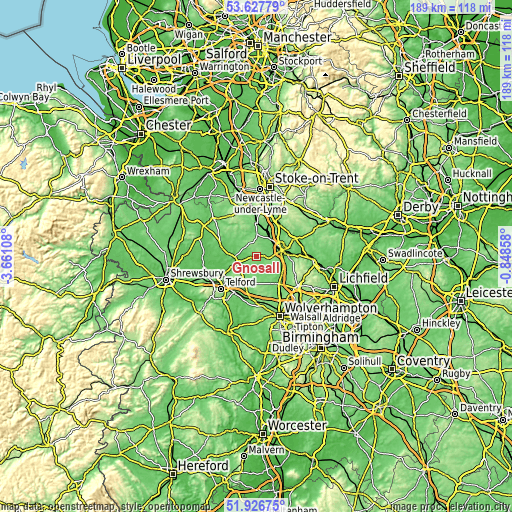
| \ | Map #1 | Map #2 | Topo.Map |
| Scale [m] | 74..142 m | 66..156 m | × |
| Scale [ft] | 243..466 ft | 217..512 ft | × |
| Average | 110.2 m = 362 ft | 104.2 m = 342 ft | × |
| Width | 5.91 km = 3.7 mi | 11.82 km = 7.3 mi | 189.1 km = 117.5 mi |
| Height | 5.91 km = 3.7 mi | 11.82 km = 7.3 mi | 189.1 km = 117.5 mi |
| ↑Max Latitude | 52.81215° | 52.838704° | 53.62779° |
| Latitude at center | 52.78558° | 52.78558° | 52.78558° |
| ↓Min Latitude | 52.758994° | 52.732391° | 51.92675° |
| ← Min Longitude | -2.298775° | -2.342721° | -3.66108° |
| Longitude center | -2.25483° | -2.25483° | -2.25483° |
| →Max Longitude | -2.210885° | -2.166939° | -0.84858° |
Nearby cities:
Cities around Gnosall sort by population:
• Stafford elevation 77 m
9.6 km,  76°
76°
• Stone 94 m
15 km,  26°
26°
• Newport 75 m
8.5 km,  255°
255°
• Penkridge 82 m
11.5 km,  125°
125°
• Standon 129 m
14.7 km,  352°
352°
• Woodcote 112 m
7.9 km,  222°
222°
• Eccleshall 98 m
8 km,  2°
2°
• Brewood 113 m
13.2 km,  155°
155°
• Wheaton Aston 112 m
8.6 km, 164°
• Edgmond 77 m
10.5 km, 262°
• Tong 94 m
13.6 km,  192°
192°
• Chetwynd 87 m
9.8 km,  268°
268°
Multilingual:
 En español:
Gnosall elevación 102 m.
 En France:
Gnosall élévation 102 m.


Sources and notes:
- [note 1] Map square and city borders are not equal. Map elevation data is calculated only from area inside that square.
- [src 1] Elevation data from geonames database provided with same terms of usage.
- [src 2] The elevation map of Gnosall is generated using elevation data from NASA's 3 arcsec (90m) resolution SRTM data.
- [src 3] Base (background) map © OpenStreetMap contributors tiles are generated by Geofabrik and OpenTopoMap.
Copyright & License:
This Gnosall Elevation Map is licensed under CC BY-SA. You may reuse any part from this page, if you give a proper credit by linking to this URL:
 More info on terms of use page.