Glasgow elevation
Glasgow (Scotland, Glasgow City), United Kingdom elevation is 40 meters and Glasgow elevation in feet is 131 ft above sea level [src 1]. Glasgow is a seat of a second-order administrative division (feature code) with elevation that is 32 meters (105 ft) smaller than average city elevation in United Kingdom.
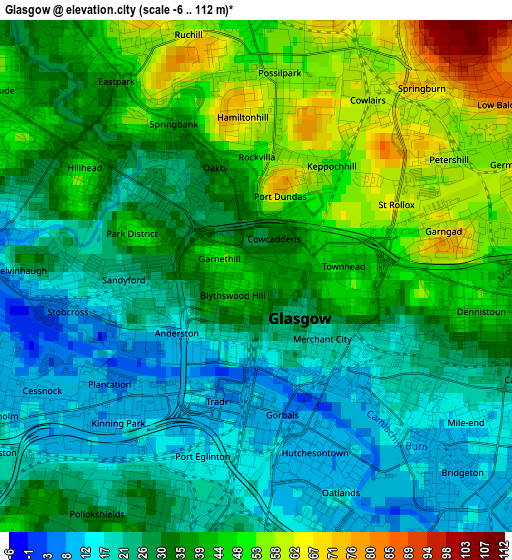
Below is the Elevation map of Glasgow, which displays elevation range with different colors. Scale of the first map is from -6 to 112 m (-20 to 367 ft) with average elevation of 33.9 meters (=111 ft) [note 1]
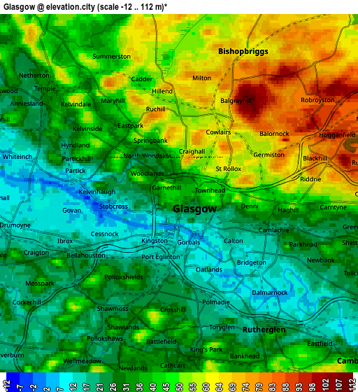
These maps also provides idea of topography and contour of this city, they are displayed at different zoom levels. More info about maps, scale and edge coordinates you can find below images.
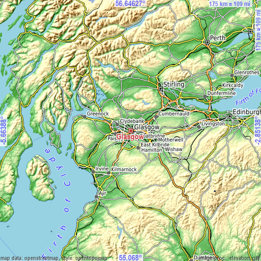
| \ | Map #1 | Map #2 | Topo.Map |
| Scale [m] | -6..112 m | -12..112 m | × |
| Scale [ft] | -20..367 ft | -39..367 ft | × |
| Average | 33.9 m = 111 ft | 38.7 m = 127 ft | × |
| Width | 5.48 km = 3.4 mi | 10.97 km = 6.8 mi | 175.5 km = 109.1 mi |
| Height | 5.48 km = 3.4 mi | 10.97 km = 6.8 mi | 175.5 km = 109.1 mi |
| ↑Max Latitude | 55.889802° | 55.914438° | 56.64627° |
| Latitude at center | 55.86515° | 55.86515° | 55.86515° |
| ↓Min Latitude | 55.840483° | 55.8158° | 55.068° |
| ← Min Longitude | -4.301575° | -4.345521° | -5.66388° |
| Longitude center | -4.25763° | -4.25763° | -4.25763° |
| →Max Longitude | -4.213685° | -4.169739° | -2.85138° |
Nearby cities:
Cities around Glasgow sort by population:
• Rutherglen elevation 23 m
4.9 km,  145°
145°
• Cambuslang 76 m
8.6 km,  135°
135°
• Bearsden 49 m
7.3 km,  319°
319°
• Bishopbriggs 60 m
5.2 km,  27°
27°
• Renfrew 7 m
8.5 km,  275°
275°
• Giffnock 45 m
7.2 km,  198°
198°
• Clarkston 95 m
8.9 km,  187°
187°
• Stepps 85 m
7.1 km,  68°
68°
• Netherlee 55 m
7.1 km, 187°
• Thornliebank 48 m
7.7 km,  209°
209°
• Torrance 49 m
8.8 km,  19°
19°
• Carmunnock 138 m
8.4 km,  170°
170°
Multilingual:
 En español:
Glasgow elevación 40 m.
 En France:
Glasgow élévation 40 m.


Sources and notes:
- [note 1] Map square and city borders are not equal. Map elevation data is calculated only from area inside that square.
- [src 1] Elevation data from geonames database provided with same terms of usage.
- [src 2] The elevation map of Glasgow is generated using elevation data from NASA's 3 arcsec (90m) resolution SRTM data.
- [src 3] Base (background) map © OpenStreetMap contributors tiles are generated by Geofabrik and OpenTopoMap.
Copyright & License:
This Glasgow Elevation Map is licensed under CC BY-SA. You may reuse any part from this page, if you give a proper credit by linking to this URL:
 More info on terms of use page.