Gresford elevation
Gresford (Wales, Wrexham), United Kingdom elevation is 76 meters and Gresford elevation in feet is 249 ft above sea level [src 1]. Gresford is a populated place (feature code) with elevation that is 4 meters (13 ft) bigger than average city elevation in United Kingdom.
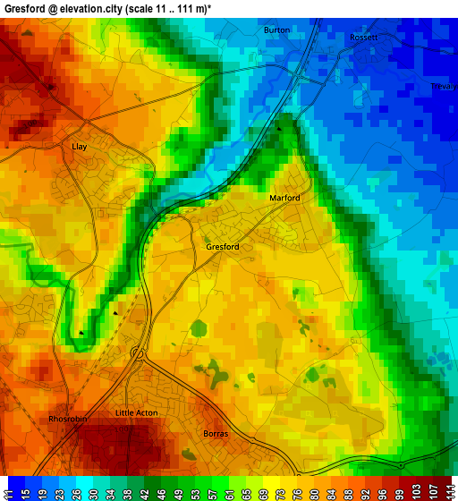
Below is the Elevation map of Gresford, which displays elevation range with different colors. Scale of the first map is from 11 to 111 m (36 to 364 ft) with average elevation of 61.6 meters (=202 ft) [note 1]
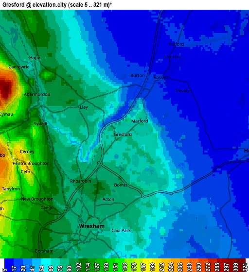
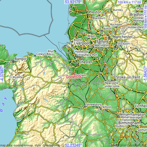
These maps also provides idea of topography and contour of this city, they are displayed at different zoom levels. More info about maps, scale and edge coordinates you can find below images.
| \ | Map #1 | Map #2 | Topo.Map |
| Scale [m] | 11..111 m | 5..321 m | × |
| Scale [ft] | 36..364 ft | 16..1053 ft | × |
| Average | 61.6 m = 202 ft | 63.9 m = 210 ft | × |
| Width | 5.87 km = 3.6 mi | 11.74 km = 7.3 mi | 187.8 km = 116.7 mi |
| Height | 5.87 km = 3.6 mi | 11.74 km = 7.3 mi | 187.8 km = 116.7 mi |
| ↑Max Latitude | 53.111777° | 53.138147° | 53.92175° |
| Latitude at center | 53.08539° | 53.08539° | 53.08539° |
| ↓Min Latitude | 53.058987° | 53.032568° | 52.23245° |
| ← Min Longitude | -3.014565° | -3.058511° | -4.37687° |
| Longitude center | -2.97062° | -2.97062° | -2.97062° |
| →Max Longitude | -2.926675° | -2.882729° | -1.56437° |
Nearby cities:
Cities around Gresford sort by population:
• Wrexham elevation 87 m
4.5 km,  197°
197°
• Brymbo 248 m
6.7 km,  252°
252°
• Broughton 27 m
8.8 km,  350°
350°
• Coedpoeth 205 m
7.1 km,  240°
240°
• Hope 87 m
5.4 km,  309°
309°
• Caergwrle 91 m
5.2 km,  300°
300°
• Penyffordd 103 m
8.6 km,  324°
324°
• Rossett 20 m
3.2 km,  33°
33°
• Marchwiel 64 m
6.9 km,  174°
174°
• Aldford 16 m
8.3 km,  55°
55°
• Farndon 28 m
6.4 km,  91°
91°
• Holt 10 m
6.2 km,  109°
109°
Multilingual:
 En español:
Gresford elevación 76 m.
 En France:
Gresford élévation 76 m.


Sources and notes:
- [note 1] Map square and city borders are not equal. Map elevation data is calculated only from area inside that square.
- [src 1] Elevation data from geonames database provided with same terms of usage.
- [src 2] The elevation map of Gresford is generated using elevation data from NASA's 3 arcsec (90m) resolution SRTM data.
- [src 3] Base (background) map © OpenStreetMap contributors tiles are generated by Geofabrik and OpenTopoMap.
Copyright & License:
This Gresford Elevation Map is licensed under CC BY-SA. You may reuse any part from this page, if you give a proper credit by linking to this URL:
 More info on terms of use page.