Penyffordd elevation
Penyffordd (Wales, County of Flintshire), United Kingdom elevation is 103 meters and Penyffordd elevation in feet is 338 ft above sea level [src 1]. Penyffordd is a populated place (feature code) with elevation that is 31 meters (102 ft) bigger than average city elevation in United Kingdom.
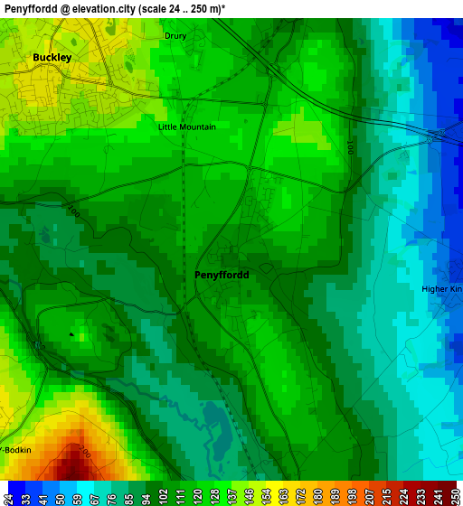
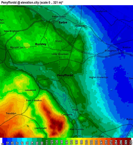
Below is the Elevation map of Penyffordd, which displays elevation range with different colors. Scale of the first map is from 24 to 250 m (79 to 820 ft) with average elevation of 104.6 meters (=343 ft) [note 1]
These maps also provides idea of topography and contour of this city, they are displayed at different zoom levels. More info about maps, scale and edge coordinates you can find below images.
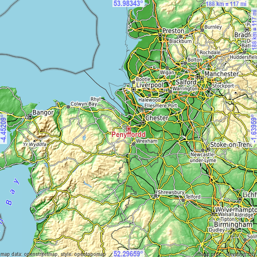
| \ | Map #1 | Map #2 | Topo.Map |
| Scale [m] | 24..250 m | 0..321 m | × |
| Scale [ft] | 79..820 ft | 0..1053 ft | × |
| Average | 104.6 m = 343 ft | 100.6 m = 330 ft | × |
| Width | 5.86 km = 3.6 mi | 11.72 km = 7.3 mi | 187.6 km = 116.6 mi |
| Height | 5.86 km = 3.6 mi | 11.72 km = 7.3 mi | 187.5 km = 116.5 mi |
| ↑Max Latitude | 53.174638° | 53.20097° | 53.98343° |
| Latitude at center | 53.14829° | 53.14829° | 53.14829° |
| ↓Min Latitude | 53.121926° | 53.095546° | 52.29659° |
| ← Min Longitude | -3.089785° | -3.133731° | -4.45209° |
| Longitude center | -3.04584° | -3.04584° | -3.04584° |
| →Max Longitude | -3.001895° | -2.957949° | -1.63959° |
Nearby cities:
Cities around Penyffordd sort by population:
• Buckley elevation 157 m
3.2 km,  309°
309°
• Deeside 28 m
5.8 km,  4°
4°
• Hawarden 78 m
4.3 km,  18°
18°
• Mold 115 m
6.7 km,  287°
287°
• Broughton 27 m
3.9 km,  65°
65°
• Gresford 76 m
8.6 km,  144°
144°
• Hope 87 m
3.6 km,  166°
166°
• Caergwrle 91 m
4.3 km, 173°
• Leeswood 163 m
3.6 km,  243°
243°
• Rossett 20 m
8 km,  122°
122°
• Treuddyn 236 m
6.2 km,  233°
233°
• Queensferry 25 m
5.8 km,  8°
8°
Multilingual:
 En español:
Penyffordd elevación 103 m.
 En France:
Penyffordd élévation 103 m.
 Auf Deutsch:
Penyffordd höhe über dem Meeresspiegel ist 103 m.

Sources and notes:
- [note 1] Map square and city borders are not equal. Map elevation data is calculated only from area inside that square.
- [src 1] Elevation data from geonames database provided with same terms of usage.
- [src 2] The elevation map of Penyffordd is generated using elevation data from NASA's 3 arcsec (90m) resolution SRTM data.
- [src 3] Base (background) map © OpenStreetMap contributors tiles are generated by Geofabrik and OpenTopoMap.
Copyright & License:
This Penyffordd Elevation Map is licensed under CC BY-SA. You may reuse any part from this page, if you give a proper credit by linking to this URL:
 More info on terms of use page.