Farndon elevation
Farndon (England, Cheshire West and Chester), United Kingdom elevation is 28 meters and Farndon elevation in feet is 92 ft above sea level [src 1]. Farndon is a seat of a third-order administrative division (feature code) with elevation that is 44 meters (144 ft) smaller than average city elevation in United Kingdom.
Below is the Elevation map of Farndon, which displays elevation range with different colors. Scale of the first map is from 5 to 37 m (16 to 121 ft) with average elevation of 16.8 meters (=55 ft) [note 1]
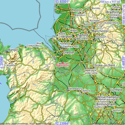
These maps also provides idea of topography and contour of this city, they are displayed at different zoom levels. More info about maps, scale and edge coordinates you can find below images.
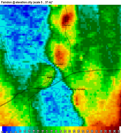
| \ | Map #1 | Topo.Map |
| Scale [m] | 5..37 m | × |
| Scale [ft] | 16..121 ft | × |
| Average | 16.8 m = 55 ft | × |
| Width | 5.87 km = 3.6 mi | 187.8 km = 116.7 mi |
| Height | 5.87 km = 3.6 mi | 187.8 km = 116.7 mi |
| ↑Max Latitude | 53.109998° | 53.92001° |
| Latitude at center | 53.08361° | 53.08361° |
| ↓Min Latitude | 53.057206° | 52.23064° |
| ← Min Longitude | -2.918585° | -4.28089° |
| Longitude center | -2.87464° | -2.87464° |
| →Max Longitude | -2.830695° | -1.46839° |
Nearby cities:
Cities around Farndon sort by population:
• Wrexham elevation 87 m
8.8 km,  242°
242°
• Gresford 76 m
6.4 km,  271°
271°
• Rossett 20 m
5.5 km,  301°
301°
• Tattenhall 38 m
8.3 km,  59°
59°
• Malpas 100 m
10.4 km,  135°
135°
• Marchwiel 64 m
8.8 km,  221°
221°
• Aldford 16 m
4.9 km,  5°
5°
• Harthill 98 m
8.3 km,  90°
90°
• Eccleston 34 m
7.4 km,  355°
355°
• Carden 66 m
5.3 km,  103°
103°
• Coddington 22 m
3.9 km, 90°
• Holt 10 m
2 km,  197°
197°
Multilingual:
 En español:
Farndon elevación 28 m.
 En France:
Farndon élévation 28 m.


Sources and notes:
- [note 1] Map square and city borders are not equal. Map elevation data is calculated only from area inside that square.
- [src 1] Elevation data from geonames database provided with same terms of usage.
- [src 2] The elevation map of Farndon is generated using elevation data from NASA's 3 arcsec (90m) resolution SRTM data.
- [src 3] Base (background) map © OpenStreetMap contributors tiles are generated by Geofabrik and OpenTopoMap.
Copyright & License:
This Farndon Elevation Map is licensed under CC BY-SA. You may reuse any part from this page, if you give a proper credit by linking to this URL:
 More info on terms of use page.