Hadley elevation
Hadley (England, Telford and Wrekin), United Kingdom elevation is 107 meters and Hadley elevation in feet is 351 ft above sea level [src 1]. Hadley is a populated place (feature code) with elevation that is 35 meters (115 ft) bigger than average city elevation in United Kingdom.
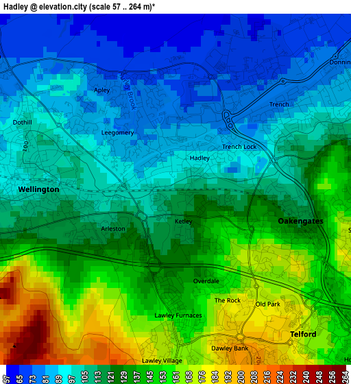
Below is the Elevation map of Hadley, which displays elevation range with different colors. Scale of the first map is from 57 to 264 m (187 to 866 ft) with average elevation of 119.7 meters (=393 ft) [note 1]
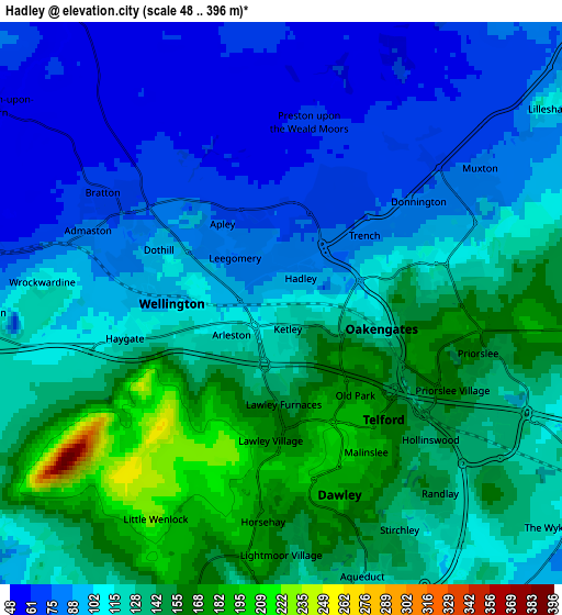
These maps also provides idea of topography and contour of this city, they are displayed at different zoom levels. More info about maps, scale and edge coordinates you can find below images.
| \ | Map #1 | Map #2 | Topo.Map |
| Scale [m] | 57..264 m | 48..396 m | × |
| Scale [ft] | 187..866 ft | 157..1299 ft | × |
| Average | 119.7 m = 393 ft | 116 m = 381 ft | × |
| Width | 5.92 km = 3.7 mi | 11.84 km = 7.4 mi | 189.5 km = 117.7 mi |
| Height | 5.92 km = 3.7 mi | 11.84 km = 7.4 mi | 189.5 km = 117.7 mi |
| ↑Max Latitude | 52.726622° | 52.753228° | 53.54388° |
| Latitude at center | 52.7° | 52.7° | 52.7° |
| ↓Min Latitude | 52.673362° | 52.646707° | 51.83949° |
| ← Min Longitude | -2.527275° | -2.571221° | -3.88958° |
| Longitude center | -2.48333° | -2.48333° | -2.48333° |
| →Max Longitude | -2.439385° | -2.395439° | -1.07708° |
Nearby cities:
Cities around Hadley sort by population:
• Telford elevation 163 m
3.5 km,  138°
138°
• Wellington 101 m
2.2 km,  270°
270°
• Newport 75 m
10.3 km,  43°
43°
• Oakengates 120 m
2.3 km,  104°
104°
• Shifnal 91 m
8.2 km,  113°
113°
• Broseley 155 m
9.7 km,  179°
179°
• Ironbridge 71 m
8 km, 180°
• Edgmond 77 m
9.6 km,  31°
31°
• Chetwynd 87 m
10.8 km, 31°
• Withington 48 m
8.1 km,  283°
283°
• Madeley 107 m
8.1 km,  155°
155°
• Eyton upon the Weald Moors 55 m
4.3 km,  328°
328°
Multilingual:
 En español:
Hadley elevación 107 m.
 En France:
Hadley élévation 107 m.


Sources and notes:
- [note 1] Map square and city borders are not equal. Map elevation data is calculated only from area inside that square.
- [src 1] Elevation data from geonames database provided with same terms of usage.
- [src 2] The elevation map of Hadley is generated using elevation data from NASA's 3 arcsec (90m) resolution SRTM data.
- [src 3] Base (background) map © OpenStreetMap contributors tiles are generated by Geofabrik and OpenTopoMap.
Copyright & License:
This Hadley Elevation Map is licensed under CC BY-SA. You may reuse any part from this page, if you give a proper credit by linking to this URL:
 More info on terms of use page.