Hagley elevation
Hagley (England, Worcestershire), United Kingdom elevation is 133 meters and Hagley elevation in feet is 436 ft above sea level [src 1]. Hagley is a populated place (feature code) with elevation that is 61 meters (200 ft) bigger than average city elevation in United Kingdom.
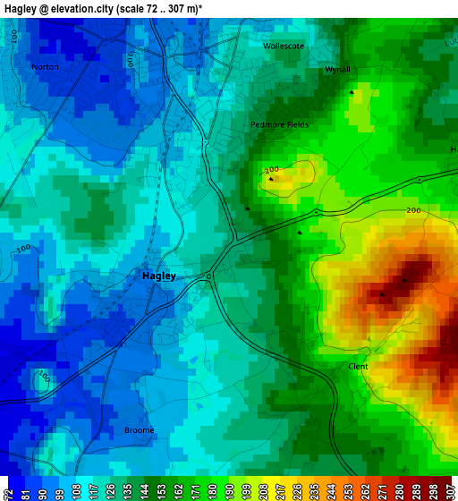
Below is the Elevation map of Hagley, which displays elevation range with different colors. Scale of the first map is from 72 to 307 m (236 to 1007 ft) with average elevation of 139.6 meters (=458 ft) [note 1]
These maps also provides idea of topography and contour of this city, they are displayed at different zoom levels. More info about maps, scale and edge coordinates you can find below images.
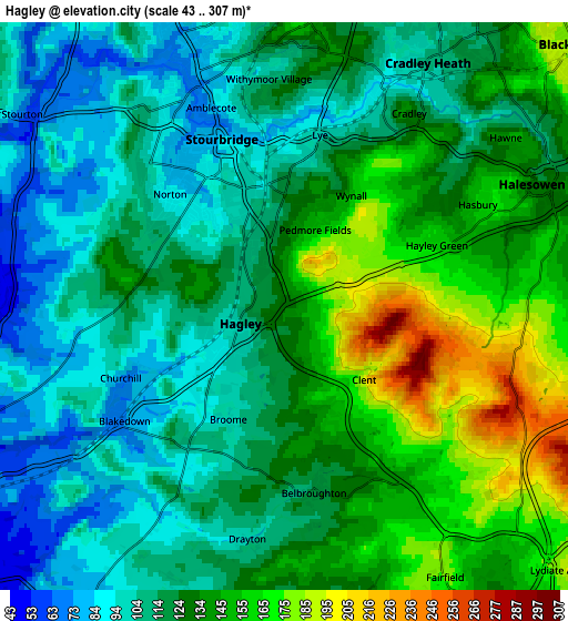
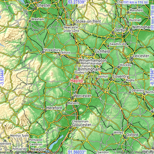
| \ | Map #1 | Map #2 | Topo.Map |
| Scale [m] | 72..307 m | 43..307 m | × |
| Scale [ft] | 236..1007 ft | 141..1007 ft | × |
| Average | 139.6 m = 458 ft | 125.7 m = 412 ft | × |
| Width | 5.96 km = 3.7 mi | 11.92 km = 7.4 mi | 190.7 km = 118.5 mi |
| Height | 5.96 km = 3.7 mi | 11.92 km = 7.4 mi | 190.7 km = 118.5 mi |
| ↑Max Latitude | 52.452989° | 52.479762° | 53.27539° |
| Latitude at center | 52.4262° | 52.4262° | 52.4262° |
| ↓Min Latitude | 52.399395° | 52.372573° | 51.56033° |
| ← Min Longitude | -2.172135° | -2.216081° | -3.53444° |
| Longitude center | -2.12819° | -2.12819° | -2.12819° |
| →Max Longitude | -2.084245° | -2.040299° | -0.72194° |
Nearby cities:
Cities around Hagley sort by population:
• Dudley elevation 161 m
8.8 km,  20°
20°
• Stourbridge 86 m
3.5 km,  343°
343°
• Halesowen 128 m
5.9 km,  65°
65°
• Brierley Hill 152 m
6.2 km,  4°
4°
• Bartley Green 189 m
8.9 km,  83°
83°
• Kingswinford 85 m
8.4 km, 340°
• Cradley Heath 109 m
6 km,  31°
31°
• Kinvere 64 m
7.6 km,  290°
290°
• Netherton 132 m
7 km, 25°
• Romsley 212 m
4.9 km,  98°
98°
• Belbroughton 116 m
3.9 km,  170°
170°
• Rowley Regis 210 m
8.5 km,  42°
42°
Multilingual:
 En español:
Hagley elevación 133 m.
 En France:
Hagley élévation 133 m.


Sources and notes:
- [note 1] Map square and city borders are not equal. Map elevation data is calculated only from area inside that square.
- [src 1] Elevation data from geonames database provided with same terms of usage.
- [src 2] The elevation map of Hagley is generated using elevation data from NASA's 3 arcsec (90m) resolution SRTM data.
- [src 3] Base (background) map © OpenStreetMap contributors tiles are generated by Geofabrik and OpenTopoMap.
Copyright & License:
This Hagley Elevation Map is licensed under CC BY-SA. You may reuse any part from this page, if you give a proper credit by linking to this URL:
 More info on terms of use page.