Hale elevation
Hale (England, Surrey), United Kingdom elevation is 108 meters and Hale elevation in feet is 354 ft above sea level [src 1]. Hale is a section of populated place (feature code) with elevation that is 36 meters (118 ft) bigger than average city elevation in United Kingdom.
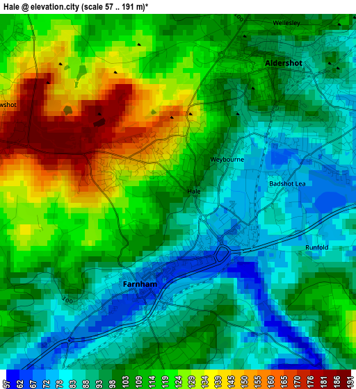
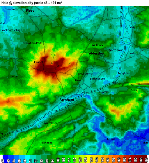
Below is the Elevation map of Hale, which displays elevation range with different colors. Scale of the first map is from 57 to 191 m (187 to 627 ft) with average elevation of 106.4 meters (=349 ft) [note 1]
These maps also provides idea of topography and contour of this city, they are displayed at different zoom levels. More info about maps, scale and edge coordinates you can find below images.
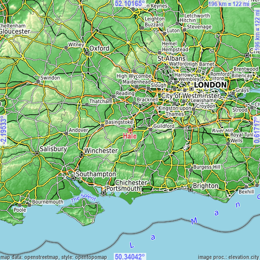
| \ | Map #1 | Map #2 | Topo.Map |
| Scale [m] | 57..191 m | 43..191 m | × |
| Scale [ft] | 187..627 ft | 141..627 ft | × |
| Average | 106.4 m = 349 ft | 93.5 m = 307 ft | × |
| Width | 6.12 km = 3.8 mi | 12.24 km = 7.6 mi | 195.8 km = 121.7 mi |
| Height | 6.12 km = 3.8 mi | 12.24 km = 7.6 mi | 195.8 km = 121.7 mi |
| ↑Max Latitude | 51.25697° | 51.284464° | 52.10165° |
| Latitude at center | 51.22946° | 51.22946° | 51.22946° |
| ↓Min Latitude | 51.201933° | 51.17439° | 50.34042° |
| ← Min Longitude | -0.833025° | -0.876971° | -2.19533° |
| Longitude center | -0.78908° | -0.78908° | -0.78908° |
| →Max Longitude | -0.745135° | -0.701189° | 0.61717° |
Nearby cities:
Cities around Hale sort by population:
• Aldershot elevation 99 m
2.7 km,  39°
39°
• Farnborough 69 m
7.6 km,  17°
17°
• Fleet 74 m
6.7 km,  332°
332°
• Farnham 71 m
1.9 km,  205°
205°
• Frimley 64 m
10.2 km, 17°
• Long Sutton 125 m
10.8 km,  264°
264°
• Odiham 96 m
10.8 km,  284°
284°
• Elstead 51 m
7.6 km,  129°
129°
• Wood Street Village 55 m
10.9 km,  77°
77°
• Normandy 55 m
8.5 km,  68°
68°
• Crondall 89 m
5.2 km,  274°
274°
• Churt 111 m
10.4 km,  174°
174°
Multilingual:
 En español:
Hale elevación 108 m.
 En France:
Hale élévation 108 m.


Sources and notes:
- [note 1] Map square and city borders are not equal. Map elevation data is calculated only from area inside that square.
- [src 1] Elevation data from geonames database provided with same terms of usage.
- [src 2] The elevation map of Hale is generated using elevation data from NASA's 3 arcsec (90m) resolution SRTM data.
- [src 3] Base (background) map © OpenStreetMap contributors tiles are generated by Geofabrik and OpenTopoMap.
Copyright & License:
This Hale Elevation Map is licensed under CC BY-SA. You may reuse any part from this page, if you give a proper credit by linking to this URL:
 More info on terms of use page.